User:Werewombat/Sandbox
Jump to navigation
Jump to search

Nonfree derivative work of a copyrighted sculpture. Freedom of panorama in the United States encompasses buildings only, not 2D or 3D works of art, including sculptures. No evidence is given that the sculpture itself is released under a license acceptable on the Commons.
Bibliographic reference:
- Smith, Dwight A. (October 3, 1983). National Register of Historic Places Inventory–Nomination Form: Columbia River Highway Historic District, OCLC 12786411.
-
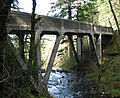
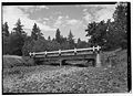
 (A) Sandy River Bridge, No. 2019
 -
 (B) Sandy River (Stark Street) Bridge, No. 11112
 -
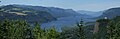 (C) Portland Women's Forum State Park
 -
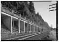
 (D) Crown Point Viaduct, No. 4524
 -
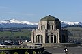 (E) Crown Point Vista House
 -
 (F) Crown Point State Park
 -
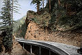
 (G) Figure Eight Loops on the Columbia River Highway
 -
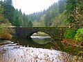
 (H) Latourell Creek Bridge, No. 4527
 -
 (I) Guy W. Talbot State Park
 -
 (J) Shepperd's Dell (Young Creek) Bridge, No. 832
 -
 (K) Shepperd's Dell State Park
 -
 (L) Bridal Veil Falls/Creek Bridge, No. 823
 -
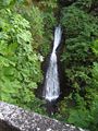
 (M) Wahkeena Falls/Creek Bridge, No. 4533
 -
 (N) Wahkeena Falls Recreation Site
 -
 (O) Wahkeena Falls Footbridge
 -
 (P) West Multnomah Falls Viaduct, No. 840
 -
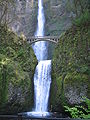
 (Q) Multnomah Falls/Creek Bridge, No. 4534
 -
 (R) Multnomah Falls Lodge
 -
 (S) Benson Footbridge / Multnomah Falls Footbridge
 -
 (T) East Multnomah Falls Viaduct, No. 841
 -
 (U) Oneonta Creek/Gorge Bridge, No. 4542
 -
 (V) Oneonta Creek/Gorge Bridge, No. 7108A
 -
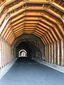
 (W) Oneonta Tunnel
 -
 (X) Horsetail Falls/Creek Bridge, No. 4543
 -
 (Y) Moffett Creek Bridge, No. 2194
 -
 (Z) Tanner Creek Bridge, No. 2062
 -
 (AA) Toothrock and Eagle Creek Viaducts
 -
 (BB) Toothrock Tunnel, No. 4555
 -
 (CC) Eagle Creek Bridge
 -
 (DD) Eagle Creek Campground and Picnic Area
 -
 (EE) Eagle Creek Overlook Picnic Area
 -
 (FF) Ruckel Creek Bridge
 -
 (GG) Gorton Creek Bridge
 -
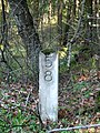 (HH) Original Mile Post Marker 58
 -
 (II) Ruthton Point Viaduct, No. 273
 -
 (JJ) Hood River Loops on the Columbia River Highway
 -
 (KK) Rock Slide Viaduct, No. 504
 -
 (LL) Mosier Twin Tunnels, No. 653
 -
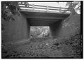
 (MM) Rock Creek Bridge, No. 203
 -
 (NN) Mosier Creek Bridge, No. 498
 -
 (OO) Memaloose Overlook
 -
 (PP) Hog Creek Canyon (Rowena Dell) Bridge, No. 523
 -
 (QQ) Dry Canyon Creek Bridge, No. 524
 -
 (RR) Rowena Crest Overlook, Mayer State Park
 -
 (SS) Rowena Loops on the Columbia River Highway
 -
(TT) Abandoned Railroad Grade, Columbia River Highway
-
 (UU) Chenoweth Creek Bridge, No. 506


_(mulDA0040a).jpg)


.jpg)


| Keep an eye on... | Missing legal information | Backlogs are fun | |||
|---|---|---|---|---|---|
| Protected edit requests (5) | 57 | Disputed copyright status (2) | 19778 | Copyright violations (9) | 9 |
| Requests for unblock (1) | 2 | Images with poor sources | 375 | Duplicate | 26 |
| Malformed deletion requests | 0 | No source (4) | 40363 | Other speedy deletions (65) | 11 |
| Incomplete deletion requests - missing reason | 0 | Own work claimed | 0 | Non-free logos | 0 |
| Deletion requests - No timestamp given | 0 | PD images without reason | 15 | Unsourced reviewed Flickr images | 0 |
| Requested moves (all) (298) | 0 | PD tag needs updating (6) | 45 | Recent unfree Flickr images | 2 |
| © Free Use w/o Rationale | 0 | Possibly unfree Flickr images reviewed by FlickreviewR | 0 | ||
| No VRTS permission | 1 | Flickr images needing human review (10) | 348 | ||
| Items missing VRTS ticket ID | 0 | Possibly unfree Flickr images (2) | 0 | ||
| Consent queried | 35 | Derivative works with broken file links | 0 | ||
| License review needed (54) | 104734 | Extracted images with broken file links | 2405 | ||