User:Threedots/Graphics and Maps
Jump to navigation
Jump to search

All graphics and maps are made with Adobe Photoshop, Corel Draw or Gimp. They are licensed under the GNU FDL and CC-by-sa-2.0-de. Well, that means they are not mine but ours - ask for a .psd- / .xcf-file or tell me what should be changed, added, corrected or if you need another language version.
-
 Map of the Ruhr Area, Germany
 -
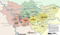 Administration of the Ruhr Area, Germany
 -
 Symbol of Mining (german: "Schlägel und Eisen")
 -
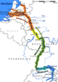 Map of the european river rhine
 -
 Map of the european river danube
 -
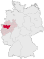 Position of the Ruhr Area in Germany
 -
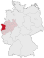 Position of the region "Niederrhein" in Germany
 -
 coat of arms of Dorsten
 -
 the Niederrhein region
 -
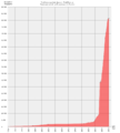 Population statistics of Dorsten
 -
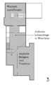
 Jewish museum westphalia
 -

-
-
 Castle Raesfeld
 -
 Grenzlandring
 -
 coal mine König Ludwig, Recklinghausen
 -
 Kreis Recklinghausen COA


