User:Notuncurious/Gallery.maps
Jump to navigation
Jump to search

Maps[edit]
-
 Cymydau of Medieval Wales
 -
 Rivers and Lakes of Wales
 -
 Northern Britain (topo), with walls (Hadrian's and Antonine)
 -
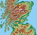 Central Scotland (topographic)
 -
 People's of southern Scotland mentioned by Ptolemy, located according to William Roy's Military Antiquities of the Romans in Britain (1793)
 -
 Ayrshire, with rivers and some towns
 -
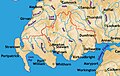 Galloway, Scotland, with rivers and some towns
 -
 Medieval Bishoprics in Scotland
 -
 Northern Britain showing Antonine and Hadrian's Walls (topographic map)
 -
 Locations of dedications to Saint Ninian (England, Scotland, Isle of Man)
 -
 Kingdom of Strathclyde, areas of influence, c. 900 – c. 1100
 -
 Anglo-Scottish border, with historical areas and dates (1227, 1482, 1552)
 -
 Modern Anglo-Scottish border
 -
 Places related to St. Tewdrig mentioned in the Book of Llandaff
 -
 Medieval Wales
 -
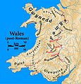 Post-Roman and Early Medieval Wales
 -
 Pre-Roman Wales
 -
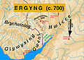 Kingdom of Ergyng, circa 700
 -
 Kingdom of Ergyng, circa 600
 -
 Kingdom of Ergyng, circa 500
 -
 Kingdom of Ergyng, circa 40
 -
 Ptolemy's map of Scotland south of the Forth (topo)
 -
 Scotland South of the Forth, c. 1200, Regions and Languages (topo)
 -
 Distribution of Norse Placenames in Cumbria, Isle of Man, Dumfriesshire
 -
 Carrick, 13th – 14th century
 -
 Carrick, 13th – 14th century (with locator)
 -
 British Coalfields, 19th Century
 -
 Yr Hen Ogledd (The Old North) c. 550 – c. 650
 -
 Roman Forts on the Antonine Wall
 -
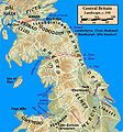 Central Britain, c. 550
 -
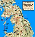 The Rise of Northumbria, 600 – 700
 -
 Cantrefi of Medieval Wales
 -
 Cantrefi of Medieval Wales (Norse legend)
 -
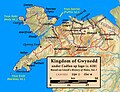
 Kingdom of Gwynedd, c. 830
 -
 The Middle Country (Y Berfeddwlad), c. 830
 -
 Kingdom of Gwynedd, c. 620
 -
 Britain, c. 540, in the time of Gildas
 -
 Stone Inscriptions in Wales, with and w/o Ogham
 -
 Stone Inscriptions in Cornwall and Devon, with and w/o Ogham
 -
 Settlement of the Déisi and Uí Liatháin in Britain
 -
 Rhwng Gwy a Hafren ("Between Wye and Severn")


Roman Britain[edit]
-
 Peoples of Northern Britain according to Ptolemy's map
 -
 Ptolemy's map of Scotland south of the Forth
 -
 British Campaigns of Agricola, 78 – 84
 -
 Northern British Campaigns of Agricola, 80 – 84
 -
 Roman Britain, Northern Campaigns (208 – 211) – The Severan Campaigns
 -
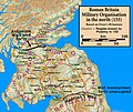
 Roman Scotland, Military Organisation (370)
 -
 Roman Scotland, Military Organisation (270)
 -
 Roman Scotland, Military Organisation (180)
 -
 Roman Scotland, Military Organisation (155)
 -
 Roman Scotland, Military Organisation (130)
 -
 Roman Scotland, Military Organisation (84)
 -
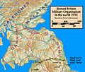
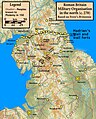
 Roman Britain, Military Organisation in the north (370)
 -
 Roman Britain, Military Organisation in the north (270)
 -
 Roman Britain, Military Organisation in the north (180)
 -
 Roman Britain, Military Organisation in the north (155)
 -
 Roman Britain, Military Organisation in the north (130)
 -
 Roman Britain, Military Organisation in the north (84)
 -
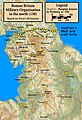
 Roman Britain, Military Organisation (68)


To pitch[edit]
-
 Iona, Scotland (monochrome)
 -
 Isle of Mull, Scotland (topographic), with Iona labeled
 -
 Isle of Mull, Scotland (topographic)
 -
 Southwestern Scotland (topographic)
 -
 Galloway, Scotland: modern names of landmarks on Ptolemy's map
 -
 Galloway, Scotland: Ptolemy's names of landmarks on Ptolemy's map
 -
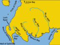
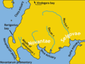
 Location of Novantae and Selgovae peoples of ancient Britain, according to Ptolemy's Geography
 -
 Ptolemy's Damnonii tribe, showing his landmarks
 -
 Galloway, Scotland (topo), with Ptolemy's towns of the Novantae and Selgovae


Nominated for deletion
File:Cunedda.invasion.jpg
File:Cunedda.kingdoms.jpg
Catchments[edit]
-
 River Tweed catchment (topographic)
 -
 Tributaries of the River Tweed catchment
 -
 River Tweed catchment within Scotland
 -
 River Tay catchment (topographic)
 -
 Tributaries of the River Tay catchment
 -
 River Tay catchment within Scotland
 -
 River Spey catchment (topographic)
 -
 Tributaries of the River Spey catchment
 -
 River Spey catchment within Scotland
 -
 River Clyde catchment (topographic)
 -
 Tributaries of the River Clyde catchment
 -
 River Clyde catchment within Scotland


From books, submaps of commons maps[edit]
-
 Govan, Scotland region (from the 1654 Blaeu map of Scotland)
 -
 subregion of Blaeu's printing of Ptolemy's map of Britain (showing Scotland)
 -
 Ptolemy's map of central Scotland (enlargement of a sub area of the source)
 -
 Map of Scottish bishoprics in the reign of David I (reigned 1124 – 1153)
 -
 Iona, showing the sites of the monasteries and abbey
 -
 The monastic church in Scotland prior to the eighth century
 -
 The state of the church in Scotland in the reign of David I


