United Nations Buffer Zone in Cyprus
Jump to navigation
Jump to search

English: This gallery contains media concerning the United Nations Buffer Zone in Cyprus, which runs for more than 180.5 kilometres (112.2 mi) along what is known as the Green Line and has an area of 346 square kilometres (134 sq mi). The zone partitions the island of Cyprus into a southern area effectively controlled by the government of the Republic of Cyprus (which is the de jure government for the entire island save for the British Sovereign Base Areas), and the northern area controlled by the Turkish Republic of Northern Cyprus.
Maps[edit]
-
 United Nations Peacekeeping Force in Cyprus desployment as of May 2011
 -
 The Attila Line Proposed by Turkey
 -
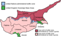 Map of the districts of Cyprus, named in English, with English annotations, and showing the Turkish Republic of Northern Cyprus, United Kingdom Sovereign Base Areas, and United Nations buffer zone.
 -
 Map of Cyprus with the UN Buffer Zone in blue. The map is adapted from the CIA World Factbook map.


Signs[edit]
-
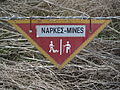 Minefield
 -
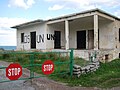
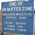 End of buffer zone
 -
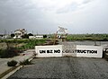 Buffer zone
 -
 The capital Nicosia remains divided since 1974. A UN buffer zone separates the two sectors.


Buildings[edit]
-
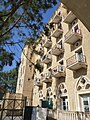 Balconies on the East façade of the Ledra Palace Hotel, with the rooms occupied by UNFICYP BRITCON troops.
 -
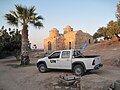 Patrol in the buffer zone near Church of Ayia Marina
 -
 kokkina


Countries of Europe: Albania · Andorra · Armenia‡ · Austria · Azerbaijan‡ · Belarus · Belgium · Bosnia and Herzegovina · Bulgaria · Croatia · Cyprus‡ · Czech Republic · Denmark · Estonia · Finland · France‡ · Georgia‡ · Germany · Greece · Hungary · Iceland · Republic of Ireland · Italy · Kazakhstan‡ · Latvia · Liechtenstein · Lithuania · Luxembourg · Malta · Moldova · Monaco · Montenegro · Netherlands‡ · North Macedonia · Norway · Poland · Portugal‡ · Romania · Russia‡ · San Marino · Serbia · Slovakia · Slovenia · Spain‡ · Sweden · Switzerland · Turkey‡ · Ukraine · United Kingdom · Vatican City
Specific status: Akrotiri and Dhekelia‡ · Faroe Islands · Gibraltar · Bailiwick of Guernsey · Isle of Man · Jersey · Svalbard – Limited recognition: Abkhazia‡ · Gagauzia · Kosovo · South Ossetia‡ · Transnistria · Northern Cyprus‡ · United Nations Buffer Zone in Cyprus‡
‡: partly located in Europe
Specific status: Akrotiri and Dhekelia‡ · Faroe Islands · Gibraltar · Bailiwick of Guernsey · Isle of Man · Jersey · Svalbard – Limited recognition: Abkhazia‡ · Gagauzia · Kosovo · South Ossetia‡ · Transnistria · Northern Cyprus‡ · United Nations Buffer Zone in Cyprus‡
‡: partly located in Europe