Template:Other versions/Topographical maps of North Rhine-Westphalia
Jump to navigation
Jump to search

[]
Attention page editors: please review Module:Multilingual description/sort and add your language in the correct order. Thank you!
- Topographic and political maps of North Rhine-Westphalia
-
 Main towns and rivers (JPG)
 -
 Main mountain ranges, rivers and landscapes/ regions (JPG)
 -
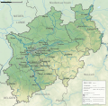
 Rivers on relief (PNG)
 -
 Political entities (JPG)
 -
 Main towns and rivers (SVG for work purposes, may not render flawlessly. Contains all objects though.)
 -
 Main mountain ranges, rivers and landscapes/ regions (SVG for work purposes, may not render flawlessly. Contains all objects though.)
 -
 Political entities (SVG for work purposes, may not render flawlessly. Contains all objects though.)


