Old maps of Amsterdam
Jump to navigation
Jump to search
[edit]
-
-
-
 Q116843326, 1678-1680


,_RP-P-AO-20-4.jpg)
Cornelis Anthonisz. (1538)[edit]
In 1538, Cornelis Anthonisz. painted the oldest surviving map of Amsterdam.
-

-
 Cornelis Anthonisz.' map inspired Jan Micker in 1652 to paint his Bird's Eye View, Amsterdam Museum
 -
 In 1544, Cornelis Anthonisz, Amsterdam Museum
 -
 Anton van den Wyngaerde, after Cornelis Anthonisz., 1547-1561


_by_Cornelis_Anthonisz.jpg)
Lodovico Guicciardini[edit]
-
 1567
1567 -
 (1581) 1588
 -
 1593-1609


Jacob van Deventer (1550-1570)[edit]
Jacob van Deventer made a map for King Philip II of Spain.

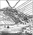
Pieter Bast (1597-1599)[edit]
-
 1597
1597

_1-1.jpg)
_1-2.jpg)
_2-1.jpg)
_2-2.jpg)
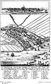
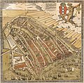
Balthasar Florisz. van Berckenrode (1625)[edit]
Balthasar Florisz van Berckenrode made this aerial map, comprising nine sheets, in 1625. This map is the most detailed of all wall maps made since the sixteenth century. Van Berckenrode's feat impressed the city's authorities, which bought sixteen copies for the sum of 300 Carolus guilders. The map was reprinted in both 1630, 1648 and 1657, with the most important changes to the cityscape added.[1]
_1-1.jpg)
_1-2.jpg)
_1-3.jpg)
_2-1.jpg)
_2-2.jpg)
_2-3.jpg)
_3-1.jpg)
_3-2.jpg)
_3-3.jpg)
Second print (1630)[edit]
_by_Balthasar_Florisz._van_Berckenrode_Universiteit_van_Amsterdam_OTM-_HB-KZL_W.X._020.jpg)
Fourth print (1657)[edit]

Joan Blaeu (1649)[edit]
.jpg)
Nicolaes Visscher (I) or Joan Blaeu (1661)[edit]


Daniel Stalpaert (1662)[edit]

Frederick de Wit (1699)[edit]
_1699-1706_by_Frederik_de_Wit.jpg)
Covens and Mortier (1748)[edit]

References[edit]
- ↑ Vogelvluchtkaart. Stadsarchief Amsterdam. Retrieved on 15 May 2012.[dead link]