<nowiki>Neresheim; Neresheim; Neresheim; Neresheim; Neresheim; Нересхайм; Neresheim; Neresheim; 內雷斯海姆; Neresheim; Neresheim; Нересгайм; 內雷斯海姆; Neresheim; Neresheim; Neresheim; Neresheim; Neresheim; Neresheim; Neresheim; Neresheim; Neresheim; Neresheim; Neresheim; Нересхајм; Neresheim; Neresheim; Neresheim; Neresheim; Neresheim; Neresheim; Neresheim; 内雷斯海姆; Neresheim; Neresheim; نيرسهايم; Neresheim; Neresheim; Neresheim; Нересхайм; Neresheim; Neresheim; Neresheim; Neresheim; Neresheim; Neresheim; Neresheim; Neresheim; Neresheim; Neresheim; Neresheim; Нересхајм; 内雷斯海姆; Neresheim; ნერესჰაიმი; ネーレスハイム; Neresheim; Neresheim; Нересхайм; Neresheim; נרסהיים; Neresheim; Neresheim; Neresheim; Neresheim; Neresheim; Neresheim; Neresheim; نرزهایم; Neresheim; Neresheim; Neresheim; Neresheim; Neresheim; Neresheimi vald; Neresheim; Nereshajm; Neresheim; Neresheim; Neresheim; Neresheim; Neresheim; Neresheim; Neresheim; Neresheim; Neresheim; Neresheim; Neresheim; Neresheim; Neresheim; Neresheim; Neresheim; Neresheim; Neresheim; Нересхайм; Ներեսհայմ; Neresheim; Neresheim; Neresheim; نرزهایم; Neresheim; Neresheim; chemun de la Germania; település Németországban; город в Германии; Stadt in Deutschland; komunë në Gjermani; քաղաք Գերմանիայում; Bajarokekî Almanyayê; ドイツ、バーデン=ヴュルテンベルク州オストアルプ郡の市; město w Badensko-Württembergskej; lungsod; miasto w Niemczech; עיר בגרמניה; gemeente in Baden-Württemberg; obec v zemském okresu Ostalb v Německu; commune allemande; localidad de Baden-Wurtemberg, Alemania; місто в Німеччині, федеральна земля Баден-Вюртемберг; municipality in Germany; komunumo de Baden-Virtembergo en Germanio; kumun alaman; città tedesca; Нересгейм; نرزهايم; Нерешеим; Нересхайм; Neresxaym; Neresheim</nowiki>
Lagekarte
Luftaufnahme (2016), Blick von Süden, am rechten Rand die Abtei Neresheim
Gesamtansicht von Westen mit Blick auf die Benediktinerabtei
Hauptstraße mit Rathaus
Neresheimer Kirchtürme v. l. n. r.: Friedhofskirche (ehemalige kath. Pfarrkirche), Kath. Stadtpfarrkirche Mariä Himmelfahrt, Rathaus (mit spitzem Glockenturm der evangelischen Gemeinde aus dem Jahr 1893), Abteikirche
Abteikirche Neresheim
Kuppelfresco v. Knoller in der Abteikirche
T33 der Härtsfeldbahn


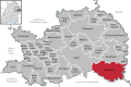 Lagekarte
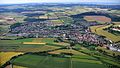 Luftaufnahme (2016), Blick von Süden, am rechten Rand die Abtei Neresheim
 Gesamtansicht von Westen mit Blick auf die Benediktinerabtei
 Hauptstraße mit Rathaus
 Neresheimer Kirchtürme v. l. n. r.: Friedhofskirche (ehemalige kath. Pfarrkirche), Kath. Stadtpfarrkirche Mariä Himmelfahrt, Rathaus (mit spitzem Glockenturm der evangelischen Gemeinde aus dem Jahr 1893), Abteikirche
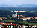
 Abteikirche Neresheim
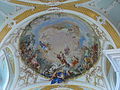 Kuppelfresco v. Knoller in der Abteikirche
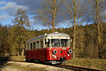 T33 der Härtsfeldbahn


