Maps of Russian federal subjects as of January 1, 2007
Jump to navigation
Jump to search
Maps of Russian federal subjects as of January 1, 2007 when Evenkia and Taymyria were merged into Krasnoyarsk Krai.
- Maps are also available as part of the
 Wikimedia Atlas of the World project in the Atlas of Russia.
Main category: Locator maps of federal subjects in Russia as of 2007-01
Autonomous okrugs[edit]
Main category: Locator maps of autonomous districts in Russia as of 2007-01
-
 Aga Buryatia
 -
 Chukotka
 -
 Khantia-Mansia
 -
 Koryakia
 -
 Nenetsia
 -
 Ust-Orda Buryatia
 -
 Yamalia


Republics[edit]
-
 Adygea
 -
 Altai
Altai -
 Buryatia
 -
 Chechnya
 -
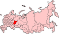
 Chuvashia
 -
 Dagestan
 -
 Ingushetia
 -
 Kabardino-Balkaria
 -
 Kalmykia
 -
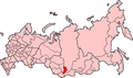
 Karachay-Cherkessia
 -
 Karelia
 -
 Khakassia
 -
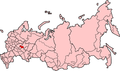
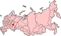
 Komi
Komi -
 Mari El
 -
 Mordovia
 -
 North Ossetia-Alania
 -
 North Ossetia-Alania
 -
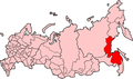
 Sakha
Sakha -
 Tatarstan
 -
 Tuva
Tuva -
 Udmurtia


Oblasts[edit]
Main category: Locator maps of oblasts in Russia as of 2007-01
See Oblasts of Russia on January 1, 2007 (Области России на 1 января 2007)
Krais[edit]
-
 Altai Krai
 -
 Khabarovsk Krai
 -
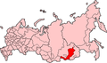
 Krasnodar Krai
 -
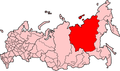
 Krasnoyarsk Krai
 -
 Perm Krai
 -
 Primorsky Krai
 -
 Stavropol Krai


