London Historic Maps Collection
Jump to navigation
Jump to search

London[edit]
This is a collection of historical maps of the London, Ontario area from 1800-1900.
The print versions of these maps were digitized by the Map and Data Centre in Western Libraries at Western University.
Larger, detailed versions of these files are available for download through Scholarship@Western
-
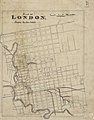
 Map of the City of London and Suburbs (1856)
 -
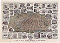 City of London, Canada, With Views of Principal Business Buildings (1893)
 -
 Proposed Route of the West Ontario Pacific Railroad through the City of London (1886)
 -
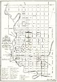
 Map of the city of London and suburbs (1878)
 -
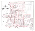
 Plan of London, Middlesex County, Ontario (1875)
 -
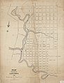
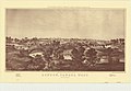 London, Canada West (1855)
 -
 The Site of London(1830)
 -
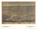
 London at the time Smallman and Ingram was founded. Bird's eye view of London, Ontario, Canada (1872)
 -
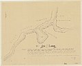
 Sketch of the fork of the River Thames, shewing(sic) the site for the City of London (1816)
 -
 Map of the city of London, surveyed and drawn by Sam'l Peters, P.L.S., published by Geo. Railton, for the London Directory, 1856
 -
 Plan of Building Lots, The Property of Colonel Askin, on the north side of Oxford Street, in the town of London C.W.
 -
 Bird's Eye View of London, Ontario, Canada (1872)
 -
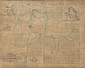
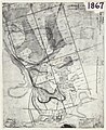 London C.W. Sketch of Country (1867)
 -
 Plan of London (1824)
 -
 Copy of part of the Township of London, copied from copy of Mr. M. Burwell's 31st May 1819 plan
 -
 Map of the City of London Canada West (1855)
 -
![School Reserve in the Broken Front of Westminster, Shewing [showing] the lots, and their respective contents, on each side of Wharncliffe Highway, and Wortley Road (1830)](https://upload.wikimedia.org/wikipedia/commons/thumb/0/0b/School_Reserve_in_the_Broken_Front_of_Westminster.jpg/120px-School_Reserve_in_the_Broken_Front_of_Westminster.jpg) School Reserve in the Broken Front of Westminster, Shewing [showing] the lots, and their respective contents, on each side of Wharncliffe Highway, and Wortley Road (1830)
School Reserve in the Broken Front of Westminster, Shewing [showing] the lots, and their respective contents, on each side of Wharncliffe Highway, and Wortley Road (1830) -
 South Part of Lot Number ine, Concession C., Township of London, Ontario, showing subdivision into lots for the Estate of the Late Sextus Kent, by Frederick Henry O.L. Surveyor (1900)
 -
 Plan of part of the City of London Ontario, showing located line of the West Ontario Pacific Railway (1892)
 -
 Crown Lands Dept Plan of London (1824)
 -
 Sketch of part of the London Township (1850)
 -
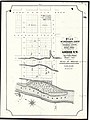
 Map of the site of proposed waterworks for the City of London at Coombs Mills & Byron, Broken Front Con'sn, Westminster (1878)
 -
 Location of Gas street lamps, includes Thames River, Railway & Lake Horn (1800)
 -
 Features of North Central London in the 1840s (1970)
 -
 Bird's eye view drawing of London, Ontario from Hobbs Manufacturing Co. (1890)
 -
 Map of London, Canada West, dated 1840 & 1841, includes measurements of lots, names of some landowners, "Glebe belonging to St. Paul's Church", and other landmarks. (1840)
 -
 Hand-drawn plan of St. Paul's Cemetery, London Canada West, circa 1852.
 -
 Plan of Woodside Survey, London South, Property of Charles Hutchinson, Esq're (1880)
 -
 Plan of the Town of London, CW, published by Thomas Craig (1846).
 -
 Hand drawn map of proposed Lorne Heights subdivision by architect J. M. Moore OLS.
 -
 Map of the Township of London, Canada West, corrected from actual survey, lithographed & published by Saml. Peters, P.L.S. & C.E. 1863.
 -
 Blueprint bounded by Mr. Higgins' property to the left side of the page, Dr. Kingsmills' property to the right, Park Avenue at the bottom of the page, and "Line between lots 6 and 7" at the top. (1900)
 -
 Military barracks: A. Mackpherson’s Building or R1 Eng. Barr(acks); B. Royal Exchange Barracks; Crystal Palace Barracks; Infantry Barracks, beside it (on east side) Prison; RA. Barracks. (1865)
 -
 Plan (in pencil) of property in the Village of Petersville (1800s)
 -
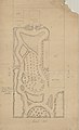 Map of proposed park bordered by Ridout St., King St. & Dundas St. adjacent to the Old Middlesex County Court House & Jail (1800s)
 -
 The map of the Lines of the London Street Railway Company from 1909 has been added over top of a map titled London Water Works, 1898. The title is handwritten on with lines of the street railway drawn on the streets. (1909)
 -
 Sketch of the position of London, U.C. Nov'r 1839 (1839)
 -
 Map of the Ontario and Quebec Ry. Detroit Extension Plan and Profile of Right-of-way Through the City of London, West of Richmond Street. (1885)
 -
 Map of Kensal Park, London, Ontario showing subdivisions of the south half of Lot No. 5 & north part of Lot No. 33, prepared for John Kent by R.P. Fairbairn. Handwritten notation outline lot locations, lots to be split, & mathematical calculations.


_the_site_for_the_City_of_London,_1816.jpg)


![School Reserve in the Broken Front of Westminster, Shewing [showing] the lots, and their respective contents, on each side of Wharncliffe Highway, and Wortley Road (1830)](/wiki/File:School_Reserve_in_the_Broken_Front_of_Westminster.jpg)


_of_property_in_the_Village_of_Petersville.jpg)


