File:Zee caerte van Engelants Eyndt, alsoe hem tselfde Landt verthoont beginnede van Sorlinges tot Pleymondt. Finis Angliae orae maritimae descriptio, et facies, a Sorlingis ad Pleymoutham. Doer Lucas Jansz Wagenaer. RMG F0351.tiff

Original file (6,900 × 5,076 pixels, file size: 100.21 MB, MIME type: image/tiff)
Captions
Captions
Summary[edit]
| Author |
Lucas Jansz Waghenaer |
| Description |
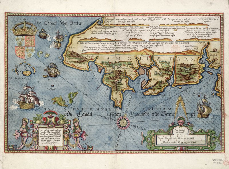
English: Zee caerte van Engelants Eyndt, alsoe hem tselfde Landt verthoont beginnede van Sorlinges tot Pleymondt. Finis Angliae orae maritimae descriptio, et facies, a Sorlingis ad Pleymoutham. Doer Lucas Jansz Wagenaer. Single sheet. Hand col. engr. Physical description Note: Very strong colour lightly varnished in places. Scale: [ca. 1:400 000 (bar)]. Cartographic Note: Ungraduated. North at 17 degrees. Soundings. Scales in Spanish miles and Dutch miles. Additional Places: Cornwall, Scilly, Devon. Contents Note: Sea decorated with ships and monster; farms and livestock on land. Grotesque scrollwork cartouches. Coat of arms.
On the back of the sheet there is a Dutch text description of the coast with woodcut views. This chart is from De Spieghel der Zeevaerdt, first published 1584. |
| Date | 1584 |
| Dimensions | Printed area 33 x 52cm, on sheet 40 x 55cm. |
| Source/Photographer | http://collections.rmg.co.uk/collections/objects/540452 |
| Permission (Reusing this file) |
The original artefact or artwork has been assessed as public domain by age, and faithful reproductions of the two dimensional work are also public domain. No permission is required for reuse for any purpose. The text of this image record has been derived from the Royal Museums Greenwich catalogue and image metadata. Individual data and facts such as date, author and title are not copyrightable, but reuse of longer descriptive text from the catalogue may not be considered fair use. Reuse of the text must be attributed to the "National Maritime Museum, Greenwich, London" and a Creative Commons CC-BY-NC-SA-3.0 license may apply if not rewritten. Refer to Royal Museums Greenwich copyright. |
| Other versions |
|
| Identifier | Acquisition Number: NA 9106. id number: G223:2/5 |
| Collection | Charts and maps |


Licensing[edit]
|
This is a faithful photographic reproduction of a two-dimensional, public domain work of art. The work of art itself is in the public domain for the following reason:
The official position taken by the Wikimedia Foundation is that "faithful reproductions of two-dimensional public domain works of art are public domain".
This photographic reproduction is therefore also considered to be in the public domain in the United States. In other jurisdictions, re-use of this content may be restricted; see Reuse of PD-Art photographs for details. | ||||
File history
Click on a date/time to view the file as it appeared at that time.
| Date/Time | Thumbnail | Dimensions | User | Comment | |
|---|---|---|---|---|---|
| current | 20:10, 6 September 2017 |  | 6,900 × 5,076 (100.21 MB) | Fæ (talk | contribs) | Royal Museums Greenwich Charts and maps, http://collections.rmg.co.uk/collections/objects/540452 #1064-2 |
You cannot overwrite this file.
File usage on Commons
The following 3 pages use this file:
- File:Zee caerte van Engelants Eyndt, alsoe hem tselfde Landt verthoont beginnede van Sorlinges tot Pleymondt. Finis Angliae orae maritimae descriptio, et facies, a Sorlingis ad Pleymoutham. Doer Lucas Jansz Wagenaer. RMG F0351.tiff
- File:Zee caerte van Engelants Eyndt, alsoe hem tselfde Landt verthoont beginnede van Sorlinges tot Pleymondt. Finis Angliae orae maritimae descriptio, et facies, a Sorlingis ad Pleymoutham. Doer Lucas Jansz Wagenaer. RMG L8557-001.jpg
- File:Zee caerte van Engelants Eyndt, alsoe hem tselfde Landt verthoont beginnede van Sorlinges tot Pleymondt. Finis Angliae orae maritimae descriptio, et facies, a Sorlingis ad Pleymoutham. Doer Lucas Jansz Wagenaer. RMG L8557-002.jpg