File:Willingen (Upland), Willingen, Panorama, 2011-08 CN-01.jpg
Jump to navigation
Jump to search

Size of this preview: 800 × 346 pixels. Other resolutions: 320 × 138 pixels | 640 × 277 pixels | 1,024 × 443 pixels | 1,280 × 554 pixels | 2,560 × 1,108 pixels | 7,071 × 3,060 pixels.
Original file (7,071 × 3,060 pixels, file size: 11.34 MB, MIME type: image/jpeg)
Captions
Captions
Add a one-line explanation of what this file represents
| Description |
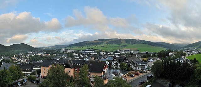
Deutsch: Panoramablick auf den Kernort Willingen der Gemeinde Willingen (Upland) im Rothaargebirge (Sauerland, Hessen) am Abend, gesehen von Nordwesten aus von der Aussichtsterasse des Kurhotels Hochsauerland 2010
English: Panoramic view on the pivotal city Willingen of the municipality Willingen (Upland) in the Rothaargebirge (Hesse, Germany), viewed in the evening from northwest
Français : Vue panoramique de Willingen, bourg central de la communauté communale de Willingen (Upland) dans les Rothaargebirge (litt.:Montagnes aux cheveux roux) dans le Sauerland, Land de Hesse, Allemagne. Photo prise en soirée, depuis la terrasse panoramique (nord-ouest) du Kurhotel Hochsauerland 2010
This photograph was taken with a Nikon D3000 |
| Date | |
| Source | Own work |
| Author | kaʁstn Disk/Cat |
| Permission (Reusing this file) |
Carschten, the copyright holder of this work, hereby publishes it under the following license: This file is licensed under the Creative Commons Attribution-Share Alike 3.0 Germany license. Attribution: Carschten
 |
| Attribution (required by the license) | © Carschten / Wikimedia Commons / |
| Camera location | | View this and other nearby images on: OpenStreetMap |
|---|
,_Willingen,_Panorama,_2011-08_CN-01.jpg¶ms=051.296548_N_0008.604891_E_globe:Earth_type:camera_region:DE-HE_&language=en)
| Camera Model | Nikon D3000 |
|---|---|
| Shutter speed | 1/80s |
| Aperture | F8.0 |
| Film speed (ISO) | 100 |
| Focal length | 18mm |
| Annotations | This image is annotated: View the annotations at Commons |
,_Willingen,_Panorama,_2011-08_CN-01.jpg)
File history
Click on a date/time to view the file as it appeared at that time.
| Date/Time | Thumbnail | Dimensions | User | Comment | |
|---|---|---|---|---|---|
| current | 17:21, 21 August 2011 | | 7,071 × 3,060 (11.34 MB) | Carschten (talk | contribs) | some soft diffusing |
| 13:15, 21 August 2011 |  | 7,071 × 3,060 (12.77 MB) | Carschten (talk | contribs) | cropped, removed dust | |
| 12:26, 21 August 2011 |  | 7,071 × 3,112 (12.89 MB) | Carschten (talk | contribs) | {{subst:User:Carschten/pic | Beschreibung = {{de|Panoramablick auf den Kernort ''Willingen'' der Gemeinde Willingen (Upland) im Rothaargebirge (Sauerland, Hessen) am |
You cannot overwrite this file.
File usage on Commons
The following 3 pages use this file:
,_Willingen,_Panorama,_2011-08_CN-01.jpg)
File usage on other wikis
The following other wikis use this file:
- Usage on de.wikipedia.org
- Usage on fr.wikipedia.org
- Usage on uk.wikipedia.org
,_Willingen,_Panorama,_2011-08_CN-01.jpg&oldid=645206582)