File:Wappen Oberjosbach.png
Jump to navigation
Jump to search

Size of this preview: 629 × 600 pixels. Other resolutions: 252 × 240 pixels | 503 × 480 pixels | 805 × 768 pixels | 1,074 × 1,024 pixels | 1,579 × 1,506 pixels.
Original file (1,579 × 1,506 pixels, file size: 4.33 MB, MIME type: image/png)
Captions
Captions
Add a one-line explanation of what this file represents
Summary[edit]
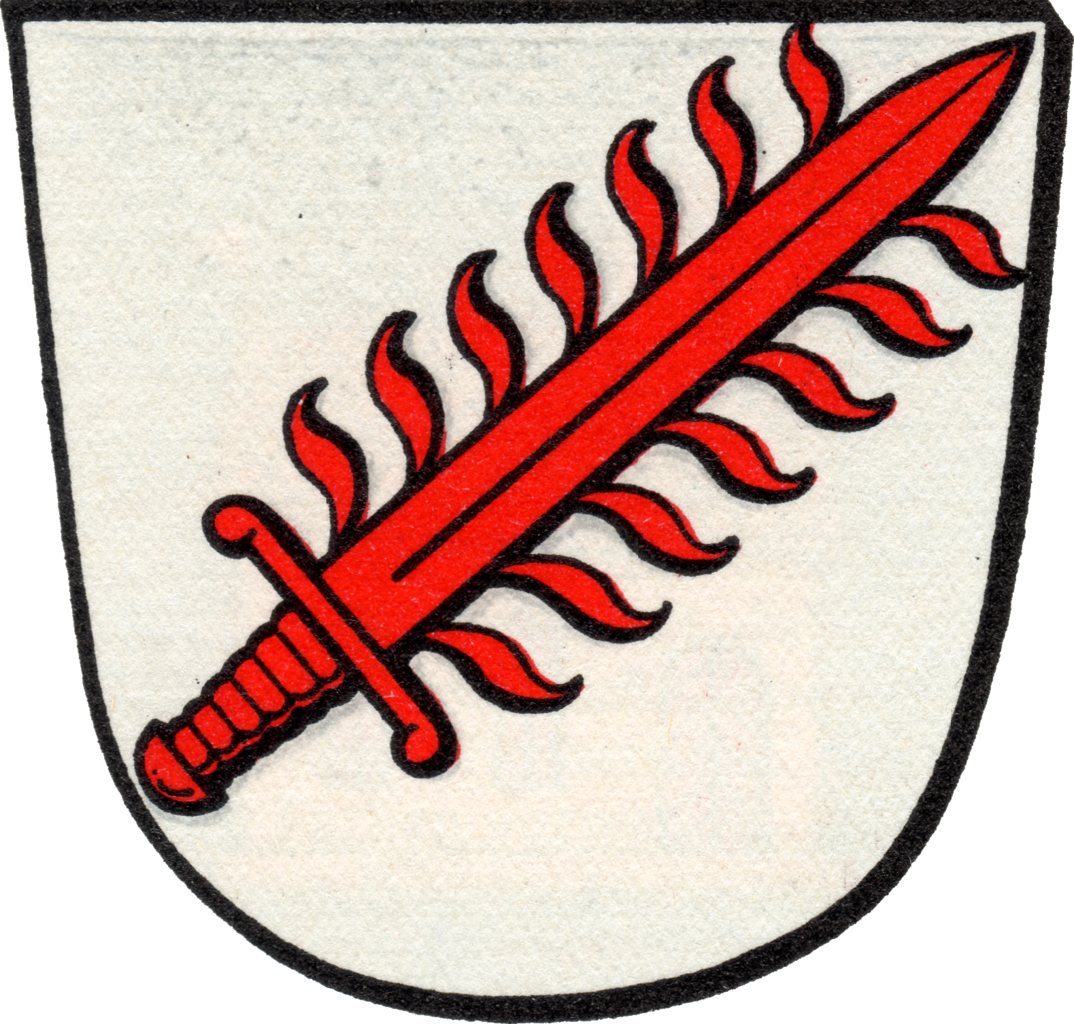
| Coat of arms | |||||||||||||||||||||||||||||||||||||||
| Blazon | Deutsch: In Silber ein schräglinks gestelltes rotes Flammenschwert. |
||||||||||||||||||||||||||||||||||||||
| Blazon reference | Deutsch: Demandt, Karl Ernst & Renkhoff, Otto. Hessisches Ortswappenbuch. Doppel-Band 1 und 2, bearbeitet im Auftrage des Staatsarchivs Wiesbaden. 1956. C. A. Starke Verlag. Glücksburg (Ostsee). p. 234. |
||||||||||||||||||||||||||||||||||||||
| Tincture (GN) | argentgules |
||||||||||||||||||||||||||||||||||||||
| Date | 1956 | ||||||||||||||||||||||||||||||||||||||
| Artist |
|
||||||||||||||||||||||||||||||||||||||
| Source | Scanned in from Demandt, Karl Ernst & Renkhoff, Otto. Hessisches Ortswappenbuch. Doppel-Band 1 und 2, bearbeitet im Auftrage des Staatsarchivs Wiesbaden. 1956. C. A. Starke Verlag. Glücksburg (Ostsee). p. 231. | ||||||||||||||||||||||||||||||||||||||
| Permission (Reusing this file) |
|
||||||||||||||||||||||||||||||||||||||


|
This coat of arms image could be re-created using vector graphics as an SVG file. This has several advantages; see Commons:Media for cleanup for more information. If an SVG form of this image is available, please upload it and afterwards replace this template with
{{vector version available|new image name}}.
It is recommended to name the SVG file “Wappen Oberjosbach.svg”—then the template Vector version available (or Vva) does not need the new image name parameter. |
File history
Click on a date/time to view the file as it appeared at that time.
| Date/Time | Thumbnail | Dimensions | User | Comment | |
|---|---|---|---|---|---|
| current | 23:03, 24 May 2022 | | 1,579 × 1,506 (4.33 MB) | IF3lixDE (talk | contribs) | Higher resolution scan |
| 10:02, 20 June 2014 |  | 246 × 240 (87 KB) | Ollemarkeagle (talk | contribs) | {{Information |Description= {{de|Wappen von {{Wd|Oberjosbach}}, Ortsteil von {{Wd|Niedernhausen}}}} {{en|Coat of Arms of Oberjosbach, part of {{W|Niedernhausen}}}} |Source=http://www.ngw.nl/int/dld/o/oberjosb.htm |Date= |Author={{unknown}} |Permission=... |
You cannot overwrite this file.
File usage on Commons
More than 100 pages use this file. The following list shows the first 100 pages that use this file only. A full list is available.
- File:102-Buchwald.jpg
- File:102-Lindenkopf.jpg
- File:102-Oberjosbach.jpg
- File:102-Saalbachfeld.jpg
- File:102-Schindtriescher.jpg
- File:102-VormKippel.jpg
- File:102-Zeichen-10,5.jpg
- File:5-DickeEiche.jpg
- File:5-Kombi-5,8.jpg
- File:5-Lindenkopf-L.jpg
- File:5-Oberjosbach.jpg
- File:5-Schindtriescher.jpg
- File:5-Wegweiser-5,9.jpg
- File:5-Wegweiser-6,1.jpg
- File:5-Wegweiser-6,9.jpg
- File:AmAltenRathaus3.jpg
- File:Amulett-Symbol.jpg
- File:Bembel-T-OJB.jpg
- File:Bohnheck.jpg
- File:BombenkraterOJB.jpg
- File:Buchwaldskopf-2018.jpg
- File:Buchwaldskopf.jpg
- File:Geo-Pfad.jpg
- File:Geopfad-OJB.jpg
- File:Geweih-7,3.jpg
- File:Glyzinien-Blüte.jpg
- File:Grenzstein Oberjosbach-Löwe.jpg
- File:Hartemuß-N-Pano-W.jpg
- File:Hartemuß-Winter.jpg
- File:Josbachfurt.jpg
- File:Josbachwiesen.jpg
- File:Köhler-Eiche-FS.jpg
- File:Köhler-Eiche-FW.jpg
- File:Lehrpfad-307.jpg
- File:Lindenkopf-NO.jpg
- File:Lochgewann-O-Pano-W.jpg
- File:NP-1769-Eiche.jpg
- File:NP-Baumarten.jpg
- File:NP-Brombeere.jpg
- File:NP-C-Kreislauf.jpg
- File:NP-Fichte.jpg
- File:NP-Haufen.jpg
- File:NP-Hochwald.jpg
- File:NP-Holunder.jpg
- File:NP-Holzklang.jpg
- File:NP-Insekten.jpg
- File:NP-Kulturlandschaft.jpg
- File:NP-Laub.jpg
- File:NP-Lehrpfad.jpg
- File:NP-Lärche.jpg
- File:NP-RT-Hütte.jpg
- File:NP-Schmetterlinge.jpg
- File:NP-Spechte.jpg
- File:NP-Sukzession.jpg
- File:NP-Tümpelquelle.jpg
- File:NP-Vogelbeere.jpg
- File:NP-Vogelschutz.jpg
- File:NP-Wald&Klima.jpg
- File:NP-Waldboden.jpg
- File:NP-Wasser&Wald.jpg
- File:NP-Ökosystem.jpg
- File:OJB-Dicke Eiche-F.jpg
- File:OJB-Dicke Eiche-H.jpg
- File:OJB-Dicke Eiche-W.jpg
- File:OJB-Geo-1.jpg
- File:OJB-Geo-10.jpg
- File:OJB-Geo-1A.jpg
- File:OJB-Geo-1F.jpg
- File:OJB-Geo-1M.jpg
- File:OJB-Geo-1N.jpg
- File:OJB-Geo-1Z.jpg
- File:OJB-Geo-2B.jpg
- File:OJB-Geo-2V.jpg
- File:OJB-Geo-3.jpg
- File:OJB-Geo-9.jpg
- File:Oberjosbach-Kapelle.jpg
- File:Oberjosbach-SO-Pano.jpg
- File:Oberjosbach-W-Schild.jpg
- File:OberjosbachSO.jpg
- File:Pfingstweid-Kreuz.jpg
- File:Pfingstweid-W-Pano.jpg
- File:RTV-H-Hartemuß.jpg
- File:RTV-Rathaus-OJB.jpg
- File:RapsUntertaunus.jpg
- File:Rettung-RÜD-242.jpg
- File:Rettung-RÜD-243.jpg
- File:Schindtriescher-S-Pano.jpg
- File:T-VormKippel.jpg
- File:Waldinfo-Pfad.jpg
- File:Wappen Oberjosbach.png
- File:Wegsymbol-Strandweg.jpg
- File:Weiberlenner-Pano.jpg
- File:Weiberlenner.jpg
- Template:DE OJB
- Category:1723 works in Taunus
- Category:Dicke Eiche (Oberjosbach)
- Category:Flag icon templates of subdivisions from states of Germany
- Category:Geo-Erlebnispfad Oberjosbach
- Category:Großer Lindenkopf
- Category:Oberjosbach
View more links to this file.
File usage on other wikis
The following other wikis use this file:
- Usage on de.wikipedia.org
- Usage on www.wikidata.org