File:Wales National Parks and AONBs map (colours).svg
Jump to navigation
Jump to search

Size of this PNG preview of this SVG file: 501 × 599 pixels. Other resolutions: 201 × 240 pixels | 401 × 480 pixels | 642 × 768 pixels | 857 × 1,024 pixels | 1,713 × 2,048 pixels | 512 × 612 pixels.
Original file (SVG file, nominally 512 × 612 pixels, file size: 681 KB)
Captions
Captions
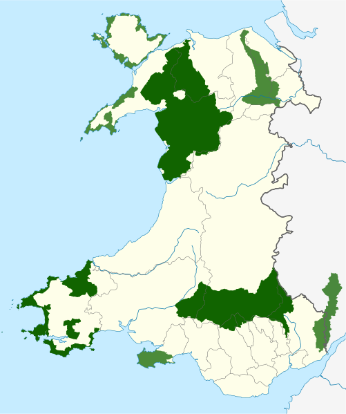
Maps of the national parks and areas of outstanding natural beauty of Wales, coloured based on designation.
Summary[edit]
.svg&action=edit§ion=1)
| Description |
English: Map of the national parks (coloured in dark green), and areas of outstanding natural beauty (lighter green) of Wales, with principal area boundaries, overlaid. |
| Date | |
| Source |
Welsh Government / Natural Resources Wales Lle Geo-Portal
Natural England UK Government (Defra)–Natural England
|
| Author |
Dank · Jay, using Natural Resources Wales and Natural England data. This vector image includes elements that have been taken or adapted from this file: This vector image includes elements that have been taken or adapted from this file: This vector image includes elements that have been taken or adapted from this file: This vector image includes elements that have been taken or adapted from this file: |
| Permission (Reusing this file) |
This file is licensed under the Creative Commons Attribution-Share Alike 3.0 Unported license. Attribution: © Natural Resources Wales. All rights reserved. © Natural England copyright 2021. © Crown copyright and database right 2021
|
| Other versions | AONBs in Wales without principal areas; Same colour map; Coloured and labelled based on designation; Labelled map |
.svg)
.svg)
File history
Click on a date/time to view the file as it appeared at that time.
| Date/Time | Thumbnail | Dimensions | User | Comment | |
|---|---|---|---|---|---|
| current | 14:46, 15 October 2021 | | 512 × 612 (681 KB) | DankJae (talk | contribs) | NP boundary correction |
| 23:15, 15 September 2021 |  | 512 × 612 (1.25 MB) | DankJae (talk | contribs) | Uploaded own work with UploadWizard |
You cannot overwrite this file.
File usage on Commons
The following 3 pages use this file:
File usage on other wikis
The following other wikis use this file:
- Usage on cy.wikipedia.org
- Eryri
- Ynys Môn
- Cadw
- Parc Cenedlaethol Bannau Brycheiniog
- Parc Cenedlaethol Arfordir Penfro
- Penrhyn Gŵyr
- Penrhyn Llŷn
- Parc Cenedlaethol Eryri
- Y Berwyn
- Dyffryn Ceiriog
- Rhestr eiddo'r Ymddiriedolaeth Genedlaethol yng Nghymru
- Bryniau Clwyd
- Elenydd
- Gwarchodfeydd Natur Cenedlaethol Cymru
- Cymdeithas Edward Llwyd
- Traethau baner las Cymru
- Parciau cenedlaethol Cymru
- Dyffryn Afon Gwy
- Adeiladau rhestredig yng Nghymru
- Rhestr Ardaloedd Cadwraeth Arbennig Cymru
- Morfa Gwent
- Ardaloedd Harddwch Naturiol Eithriadol Cymru
- Nodyn:Ardaloedd Gwarchod Cymru
- Coedwigoedd Glaw Celtaidd Cymru
- Bryniau Clwyd a Dyffryn Dyfrdwy
- Rhestr o lynoedd Eryri
- Usage on en.wikipedia.org
- Snowdonia
- Gower Peninsula
- Brecon Beacons
- List of National Trust properties in Wales
- National nature reserves in Wales
- Areas of Outstanding Natural Beauty in Wales
- List of Cadw properties
- Pembrokeshire Coast National Park
- Brecon Beacons National Park
- National parks of Wales
- Llŷn Peninsula
- List of Sites of Special Scientific Interest in Gwent
- List of SSSIs in Brecknock
- List of SSSIs in Carmarthen & Dinefwr
- List of SSSIs in Ceredigion
- List of SSSIs in Clwyd
- List of SSSIs in East Gwynedd
- List of SSSIs in Radnor
- List of SSSIs in Preseli & South Pembrokeshire
- List of SSSIs in West Glamorgan
- List of SSSIs in West Gwynedd
- List of SSSIs in Montgomery
- List of SSSIs in Mid & South Glamorgan
- Wye Valley
View more global usage of this file.
.svg)
.svg&oldid=830999101)