File:Vertical references in Europe.svg
Jump to navigation
Jump to search

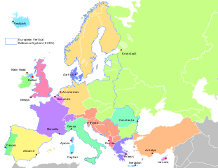
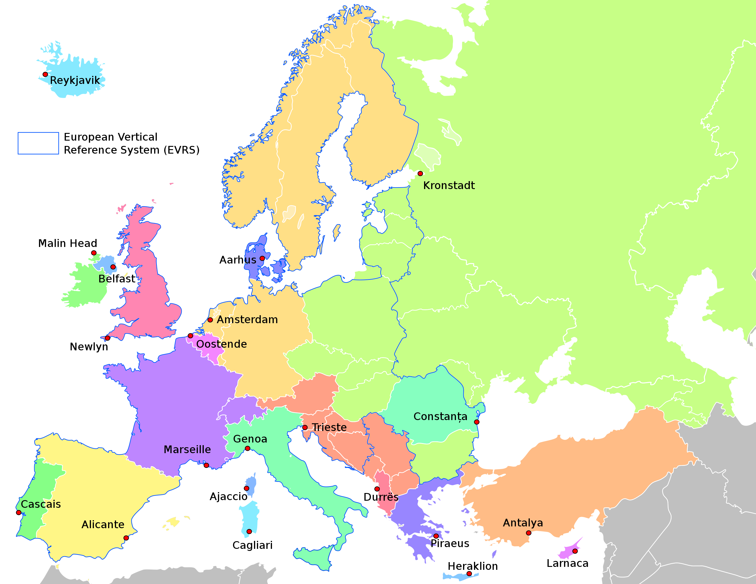
Size of this PNG preview of this SVG file: 575 × 444 pixels. Other resolutions: 311 × 240 pixels | 622 × 480 pixels | 995 × 768 pixels | 1,280 × 988 pixels | 2,560 × 1,977 pixels.
Original file (SVG file, nominally 575 × 444 pixels, file size: 525 KB)
Captions
Captions
Add a one-line explanation of what this file represents
Summary[edit]
| Description |
English: Overview of the variety of used vertical reference systems in Europe.
Deutsch: Überblick über die Vielfalt der verwendeten Höhensysteme in Europa.
Nederlands: Overzicht van de vertikale referenties in Europa. |
| Date | |
| Source | Own work |
| Author | Hans Erren |
| Other versions | Country outlines from file:Blank_political_map_Europe_in_2006_WF.svg |
Information from http://www.bkg.bund.de/evrs and http://www.epsg-registry.org/ archive copy at the Wayback Machine
Licensing[edit]
I, the copyright holder of this work, hereby publish it under the following license:
This file is licensed under the Creative Commons Attribution-Share Alike 3.0 Unported license.
- You are free:
- to share – to copy, distribute and transmit the work
- to remix – to adapt the work
- Under the following conditions:
- attribution – You must give appropriate credit, provide a link to the license, and indicate if changes were made. You may do so in any reasonable manner, but not in any way that suggests the licensor endorses you or your use.
- share alike – If you remix, transform, or build upon the material, you must distribute your contributions under the same or compatible license as the original.
File history
Click on a date/time to view the file as it appeared at that time.
| Date/Time | Thumbnail | Dimensions | User | Comment | |
|---|---|---|---|---|---|
| current | 15:37, 5 September 2022 | | 575 × 444 (525 KB) | Рагин1987 (talk | contribs) | Small correction |
| 15:34, 5 September 2022 |  | 575 × 444 (524 KB) | Рагин1987 (talk | contribs) | Correction | |
| 07:05, 2 September 2022 |  | 2,560 × 1,977 (1.05 MB) | Рагин1987 (talk | contribs) | Removed part of the borders of Turkmenistan | |
| 21:50, 12 July 2022 |  | 575 × 444 (509 KB) | Glrx (talk | contribs) | remove more CSS ID selectors // Editing SVG source code using c:User:Rillke/SVGedit.js | |
| 21:32, 12 July 2022 |  | 575 × 444 (510 KB) | Glrx (talk | contribs) | replace CSS ID selectors for ocean and lakes with class IDENTocean IDENTlakes // Editing SVG source code using c:User:Rillke/SVGedit.js | |
| 21:11, 12 July 2022 |  | 575 × 444 (510 KB) | Glrx (talk | contribs) | remove a third * CSS selector // Editing SVG source code using c:User:Rillke/SVGedit.js | |
| 21:04, 12 July 2022 |  | 575 × 444 (510 KB) | Glrx (talk | contribs) | remove * CSS selector for SVG Translate test // Editing SVG source code using c:User:Rillke/SVGedit.js | |
| 20:51, 12 July 2022 |  | 575 × 444 (510 KB) | Glrx (talk | contribs) | remove empty text element for SVG Translate test // Editing SVG source code using c:User:Rillke/SVGedit.js | |
| 18:28, 4 October 2013 |  | 575 × 444 (510 KB) | Hans Erren (talk | contribs) | Crete added, labels tweaked | |
| 18:11, 25 June 2013 |  | 575 × 444 (509 KB) | Hans Erren (talk | contribs) | finetuning |
You cannot overwrite this file.
File usage on Commons
The following page uses this file:
File usage on other wikis
The following other wikis use this file:
- Usage on cs.wikipedia.org
- Usage on de.wikipedia.org
- Usage on en.wikipedia.org
- Usage on eo.wikipedia.org
- Usage on es.wikipedia.org
- Usage on fa.wikipedia.org
- Usage on fr.wikipedia.org
- Usage on hr.wikipedia.org
- Usage on id.wikipedia.org
- Usage on it.wikipedia.org
- Usage on li.wikipedia.org
- Usage on myv.wikipedia.org
- Usage on nl.wikipedia.org
- Usage on no.wikipedia.org
- Usage on pl.wikipedia.org
- Usage on rue.wikipedia.org
- Usage on ru.wikipedia.org
- Usage on simple.wikipedia.org
- Usage on sk.wikipedia.org
- Usage on uk.wikipedia.org
- Usage on uz.wikipedia.org