File:Vermillion 380 oil platform fire location LOC 2010589315.tif
Jump to navigation
Jump to search

Size of this JPG preview of this TIF file: 776 × 600 pixels. Other resolutions: 311 × 240 pixels | 621 × 480 pixels | 994 × 768 pixels | 1,280 × 989 pixels | 2,560 × 1,978 pixels | 3,300 × 2,550 pixels.
Original file (3,300 × 2,550 pixels, file size: 24.08 MB, MIME type: image/tiff)
Captions
Captions
Add a one-line explanation of what this file represents
Summary[edit]
| Description |
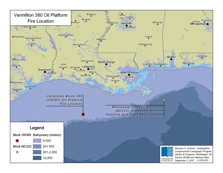
English: Depths shown by bathymetric tints. Also shows location of Deepwater Horizon platform fire. "Source: BOEM and National Atlas, September 2, 2010." Available also through the Library of Congress Web site as a raster image. |
||
| Title | Vermillion 380 oil platform fire location | ||
| Shelf ID | G3862.C6H8 2010 .J2 | ||
| Date | |||
| Source | https://www.loc.gov/item/2010589315/ | ||
| Author | Jackson, Nicholas A.; Congressional Cartography Program (Library Of Congress) | ||
| Permission (Reusing this file) |
|
||
| Other versions |
|
||
| Location | United States · Gulf Coast | ||
| Part of | American Memory · Catalog · Geography And Map Division · Additional Conservation And Environment Cartographic Items | ||
| Subject | Fires And Fire Prevention · Offshore Oil Well Drilling · Gulf Coast (U.S.) · United States · Maps · Drilling Platforms · Gulf Coast |


Licensing[edit]
| This image or media file contains material based on a work of a United States Department of the Interior employee, created as part of that person's official duties. As a work of the U.S. federal government, such work is in the public domain in the United States. See the Department of the Interior copyright policy for more information. |  |
File history
Click on a date/time to view the file as it appeared at that time.
| Date/Time | Thumbnail | Dimensions | User | Comment | |
|---|---|---|---|---|---|
| current | 06:01, 1 August 2018 |  | 3,300 × 2,550 (24.08 MB) | Fæ (talk | contribs) | LOC Maps https://www.loc.gov/item/2010589315/ #18031 |
You cannot overwrite this file.
File usage on Commons
The following page uses this file: