File:United States presidential election in Kentucky, 2016.svg
Jump to navigation
Jump to search

Size of this PNG preview of this SVG file: 544 × 600 pixels. Other resolutions: 218 × 240 pixels | 435 × 480 pixels | 697 × 768 pixels | 929 × 1,024 pixels | 1,858 × 2,048 pixels | 2,904 × 3,201 pixels.
Original file (SVG file, nominally 2,904 × 3,201 pixels, file size: 575 KB)
Captions
Captions
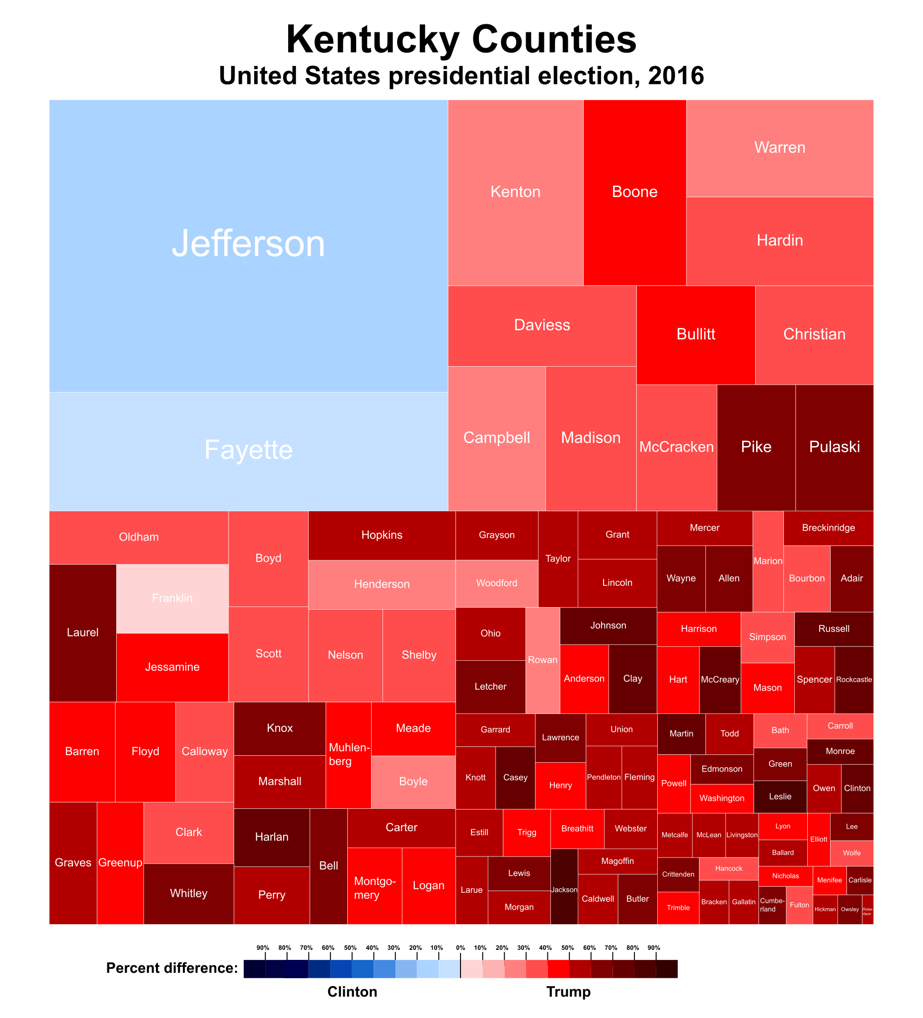
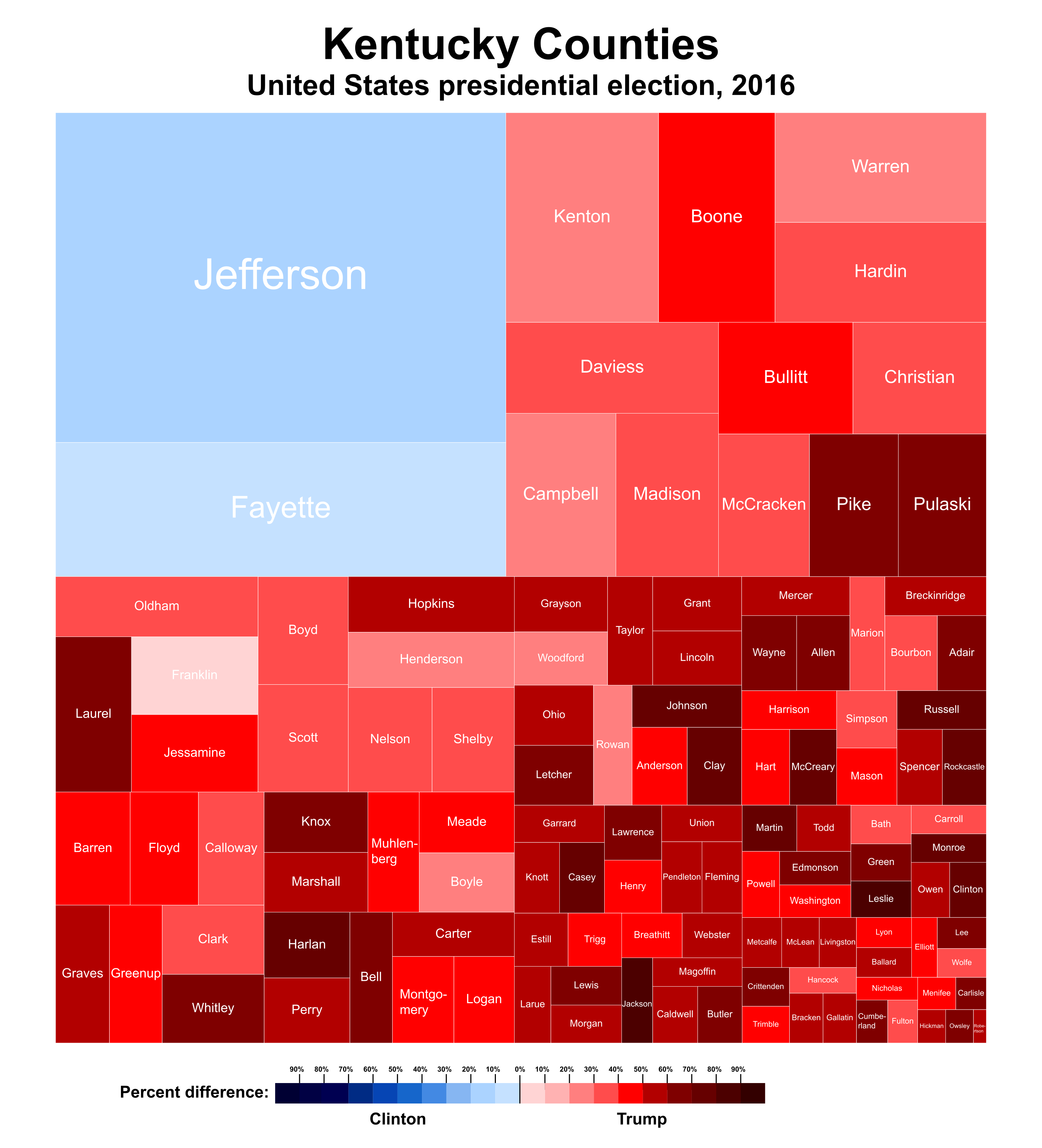
Treemap of the United States 2016 presidential election in Kentucky counties
Summary[edit]
| Description |
English: Treemap of the United States presidential election in Kentucky, 2016, breakdown by counties based on their population. |
||
| Date | |||
| Source | Raw Data:[1] | ||
| Author | Ali Zifan | ||
| Other versions |
[]
|


Licensing[edit]
I, the copyright holder of this work, hereby publish it under the following license:
This file is licensed under the Creative Commons Attribution-Share Alike 4.0 International license.
- You are free:
- to share – to copy, distribute and transmit the work
- to remix – to adapt the work
- Under the following conditions:
- attribution – You must give appropriate credit, provide a link to the license, and indicate if changes were made. You may do so in any reasonable manner, but not in any way that suggests the licensor endorses you or your use.
- share alike – If you remix, transform, or build upon the material, you must distribute your contributions under the same or compatible license as the original.
File history
Click on a date/time to view the file as it appeared at that time.
| Date/Time | Thumbnail | Dimensions | User | Comment | |
|---|---|---|---|---|---|
| current | 03:07, 23 February 2017 | | 2,904 × 3,201 (575 KB) | Oganesson007 (talk | contribs) | outline |
| 03:04, 23 February 2017 |  | 2,904 × 3,201 (65 KB) | Oganesson007 (talk | contribs) | User created page with UploadWizard |
You cannot overwrite this file.
File usage on Commons
The following 52 pages use this file:
- User:Magog the Ogre/Political maps/2017 February 19-28
- User:Oganesson007/Contributions
- File:United States presidential election in Alabama, 2016.svg
- File:United States presidential election in Arizona, 2016.svg
- File:United States presidential election in Arkansas, 2016.svg
- File:United States presidential election in California, 2016.svg
- File:United States presidential election in Colorado, 2016.svg
- File:United States presidential election in Connecticut, 2016.svg
- File:United States presidential election in Delaware, 2016.svg
- File:United States presidential election in Florida, 2016.svg
- File:United States presidential election in Georgia, 2016.svg
- File:United States presidential election in Hawaii, 2016.svg
- File:United States presidential election in Idaho, 2016.svg
- File:United States presidential election in Illinois, 2016.svg
- File:United States presidential election in Indiana, 2016.svg
- File:United States presidential election in Iowa, 2016.svg
- File:United States presidential election in Kansas, 2016.svg
- File:United States presidential election in Kentucky, 2016.svg
- File:United States presidential election in Louisiana, 2016.svg
- File:United States presidential election in Maine, 2016.svg
- File:United States presidential election in Maryland, 2016.svg
- File:United States presidential election in Massachusetts, 2016.svg
- File:United States presidential election in Michigan, 2016.svg
- File:United States presidential election in Minnesota, 2016.svg
- File:United States presidential election in Mississippi, 2016.svg
- File:United States presidential election in Missouri, 2016.svg
- File:United States presidential election in Montana, 2016.svg
- File:United States presidential election in Nebraska, 2016.svg
- File:United States presidential election in Nevada, 2016.svg
- File:United States presidential election in New Hampshire, 2016.svg
- File:United States presidential election in New Jersey, 2016.svg
- File:United States presidential election in New Mexico, 2016.svg
- File:United States presidential election in New York, 2016.svg
- File:United States presidential election in North Carolina, 2016.svg
- File:United States presidential election in North Dakota, 2016.svg
- File:United States presidential election in Ohio, 2016.svg
- File:United States presidential election in Oklahoma, 2016.svg
- File:United States presidential election in Oregon, 2016.svg
- File:United States presidential election in Pennsylvania, 2016.svg
- File:United States presidential election in Rhode Island, 2016.svg
- File:United States presidential election in South Carolina, 2016.svg
- File:United States presidential election in South Dakota, 2016.svg
- File:United States presidential election in Tennessee, 2016.svg
- File:United States presidential election in Texas, 2016.svg
- File:United States presidential election in Utah, 2016.svg
- File:United States presidential election in Vermont, 2016.svg
- File:United States presidential election in Virginia, 2016.svg
- File:United States presidential election in Washington, 2016.svg
- File:United States presidential election in West Virginia, 2016.svg
- File:United States presidential election in Wisconsin, 2016.svg
- File:United States presidential election in Wyoming, 2016.svg
- Template:2016 United States presidential election Treemaps
File usage on other wikis
The following other wikis use this file:
- Usage on en.wikipedia.org