File:United Kingdom EU referendum 2016 voting regions results.svg
Jump to navigation
Jump to search

Size of this PNG preview of this SVG file: 388 × 600 pixels. Other resolutions: 155 × 240 pixels | 310 × 480 pixels | 497 × 768 pixels | 663 × 1,024 pixels | 1,325 × 2,048 pixels | 886 × 1,369 pixels.
Original file (SVG file, nominally 886 × 1,369 pixels, file size: 2.67 MB)
Captions
Captions
Add a one-line explanation of what this file represents
Summary[edit]
| Description |
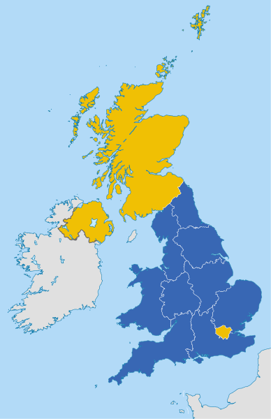
English: Map of the United Kingdom showing the regional counting areas for the European Union membership referendum, 2016.
Remain
Leave Deutsch: Karte des Vereinigten Königreichs mit den Ergebnissen des Referendums über den Verbleib des Vereinigten Königreichs in der Europäischen Union 2016.
Verbleib in der EU
Ausscheiden aus der EU |
||
| Date | |||
| Source |
This file was derived from: United Kingdom NUTS location map.svg |
||
| Author |
|
||
| Permission (Reusing this file) |
I, the copyright holder of this work, hereby publish it under the following licenses:
This file is licensed under the Creative Commons Attribution-Share Alike 4.0 International license.
You may select the license of your choice. |
||
| Other versions |
 |
||
| SVG development |

File history
Click on a date/time to view the file as it appeared at that time.
| Date/Time | Thumbnail | Dimensions | User | Comment | |
|---|---|---|---|---|---|
| current | 06:03, 14 August 2017 | | 886 × 1,369 (2.67 MB) | BurritoBazooka (talk | contribs) | tweak sea fill so that it is the same as another map frequently used with this one: File:United Kingdom EU referendum 2016 area results 2-tone.svg |
| 11:17, 24 June 2016 |  | 886 × 1,369 (2.43 MB) | Furfur (talk | contribs) | region's borders white | |
| 11:11, 24 June 2016 |  | 886 × 1,369 (2.34 MB) | Furfur (talk | contribs) | =={{int:filedesc}}== {{Information |description={{en|1=Map of the United Kingdom showing the regional counting areas for the European Union membership referendum, 2016.}} |date=2016-02-20 |source={{Derived from|United Kingdom NUTS location map.svg}} |a... |
You cannot overwrite this file.
File usage on Commons
The following 2 pages use this file:
File usage on other wikis
The following other wikis use this file:
- Usage on ar.wikipedia.org
- Usage on br.wikipedia.org
- Usage on ca.wikipedia.org
- Usage on cy.wikipedia.org
- Usage on de.wikipedia.org
- Usage on en.wikipedia.org
- Usage on es.wikipedia.org
- Usage on fr.wikipedia.org
- Usage on id.wikipedia.org
- Usage on ja.wikipedia.org
- Usage on ko.wikipedia.org
- Usage on no.wikipedia.org
- Usage on pl.wikipedia.org
- Usage on pt.wikipedia.org
- Usage on th.wikipedia.org
- Usage on zh.wikipedia.org