File:USS South Dakota superstructure RAF NARA 19LCM-BB57-1.tif
Original file (3,102 × 3,180 pixels, file size: 4.85 MB, MIME type: image/tiff)
Captions
Captions
Summary[edit]
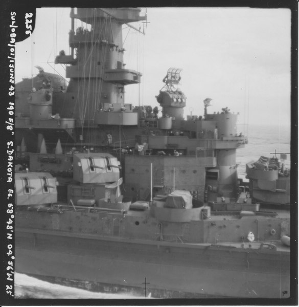
| SUL/089/01/1 June 43 190 F/8″ S. Dakota BB. 58°48′N 04°56′W 25′
( |
|||||||||||||||||||||||||||
|---|---|---|---|---|---|---|---|---|---|---|---|---|---|---|---|---|---|---|---|---|---|---|---|---|---|---|---|
| Author |
Royal Air Force |
||||||||||||||||||||||||||
| Title |
SUL/089/01/1 June 43 190 F/8″ S. Dakota BB. 58°48′N 04°56′W 25′ |
||||||||||||||||||||||||||
| Description |
Royal Air Force photograph of the USS South Dakota in 1943, in the waters outside of Scapa Flow. Box: 19LCM, BB-57, BN204; Folder N 19LCM-BB57-1 ; N.621; 2255 |
||||||||||||||||||||||||||
| Date | 1 June 1943 | ||||||||||||||||||||||||||
| Collection |
|
||||||||||||||||||||||||||
| Record ID |
|
||||||||||||||||||||||||||
| Source | U.S. National Archives and Records Administration | ||||||||||||||||||||||||||
| Other versions |
Please do not overwrite this file: any restoration work should be uploaded with a new name and linked in this page's "other versions=" parameter, so that this file represents the exact file found in the NARA catalog record to which it links. The metadata on this page was imported directly from NARA's catalog record; additional descriptive text may be added by Wikimedians to the template below with the "description=" parameter, but please do not modify the other fields.
|
||||||||||||||||||||||||||


| Camera location | | View this and other nearby images on: OpenStreetMap |
|---|
Licensing[edit]
This work created by the United Kingdom Government is in the public domain.
This is because it is one of the following:
HMSO has declared that the expiry of Crown Copyrights applies worldwide (ref: HMSO Email Reply)
|
 |
This file was provided to Wikimedia Commons by the National Archives and Records Administration as part of a cooperation project. The National Archives and Records Administration provides images depicting American and global history which are public domain or licensed under a free license.
|
File history
Click on a date/time to view the file as it appeared at that time.
| Date/Time | Thumbnail | Dimensions | User | Comment | |
|---|---|---|---|---|---|
| current | 22:25, 4 February 2012 |  | 3,102 × 3,180 (4.85 MB) | Clindberg (talk | contribs) | upload the actual photo |
| 22:23, 4 February 2012 |  | 517 × 530 (105 KB) | Clindberg (talk | contribs) |
You cannot overwrite this file.
File usage on Commons
The following 4 pages use this file: