File:USA Gebietsansprüche und -abtretungen 1782–1802.png

Original file (747 × 782 pixels, file size: 194 KB, MIME type: image/png)
Captions
Captions
Summary[edit]
| Description |
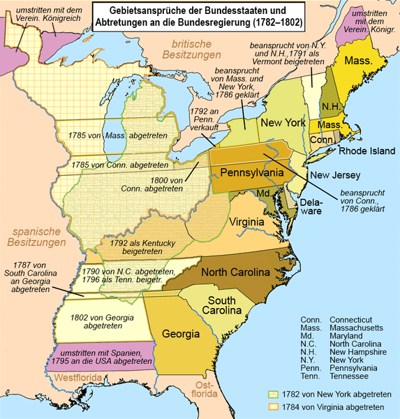
Deutsch: Gebietsansprüche der Bundesstaaten der USA und Abtretungen an die Bundesregierung (1782–1802). Grenzstreitigkeiten zwischen den Bundesstaaten, die vor der Unabhängigkeitserklärung der USA geklärt wurden, sind nicht dargestellt.
English: This is a map showing state land claims and cessions from 1782-1802 that I made. The disputed territory between New Hampshire and New York formed, in 1777, the independent country of 'New Connecticut' (later renamed 'Vermont') which eventually gained admission as the 14th state in 1791. Boundary disputes between states that were resolved before U.S. independence are not shown. |
| Date | |
| Source | Own work using: United States land claims and cessions 1782-1802.png by Kmusser |
| Author | NordNordWest (translation) |
| Other versions |
|


|
This map has been made or improved in the German Kartenwerkstatt (Map Lab). You can propose maps to improve as well.
|
Licensing[edit]
Usage of this file with:

explanatory notes: Legally binding is only the full legalcode. For a free usage I recommend to respect the following licence conditions:
1. Provide my name as given above: NordNordWest,
2. a copy of, or the URI for, the applicable license: https://creativecommons.org/licenses/by-sa/3.0/de/legalcode,
3. the title of the work,
4. in the case of an adaptation, a credit identifying the use of the work in the adaptation.
This license and the rights granted hereunder will terminate automatically upon any breach by you of the terms of this license. Any of the above conditions can be waived if you get permission from the copyright holder. If you have questions or wish differing conditions, please contact me through nnwest or my discussion page ![]() t-online.de
t-online.de
- You are free:
- to share – to copy, distribute and transmit the work
- to remix – to adapt the work
- Under the following conditions:
- attribution – You must give appropriate credit, provide a link to the license, and indicate if changes were made. You may do so in any reasonable manner, but not in any way that suggests the licensor endorses you or your use.
- share alike – If you remix, transform, or build upon the material, you must distribute your contributions under the same or compatible license as the original.

File history
Click on a date/time to view the file as it appeared at that time.
| Date/Time | Thumbnail | Dimensions | User | Comment | |
|---|---|---|---|---|---|
| current | 21:18, 16 May 2018 | | 747 × 782 (194 KB) | NordNordWest (talk | contribs) | == {{int:filedesc}} == {{Information |description= {{de|1=Gebietsansprüche der Bundesstaaten der USA und Abtretungen an die Bundesregierung (1782–1802). Grenzstreitigkeiten zwischen den Bundesstaaten, die vor der Unabhängigkeitserklärung der USA geklärt wurden, sind nicht dargestellt.}} {{en|1=This is a map showing state land claims and cessions from 1782-1802 that I made.<br />The disputed territory between New Hampshire and New York formed, in 1777, the independent country of 'New Connectic... |
You cannot overwrite this file.
File usage on Commons
The following 2 pages use this file:
File usage on other wikis
The following other wikis use this file: