File:UBahnSchemaplanMuenchenTopographisch2006.png
Jump to navigation
Jump to search

Size of this preview: 800 × 559 pixels. Other resolutions: 320 × 224 pixels | 640 × 447 pixels | 1,024 × 716 pixels | 1,280 × 895 pixels | 1,695 × 1,185 pixels.
Original file (1,695 × 1,185 pixels, file size: 383 KB, MIME type: image/png)
Captions
Captions
Add a one-line explanation of what this file represents
Summary[edit]
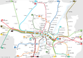
- Description:
- Deutsch: Topografischer U-Bahnplan München 2006
- Der Schemaplan des Münchner Schnellbahnnetzes ist weithin bekannt, führt uns jedoch ein Bild vor Augen, das mit den realen Lageverhältnissen der Verkehrslinien nur wenig zu tun hat. Der vorliegende, an Hand der topografischen Gegebenheiten erstellte U-Bahnplan nutzt dies und spielt mit dem Betrachter: man erkennt zwar was dargestellt ist und dennoch wirkt der Plan fremd und irritierend...
- English: Topographical rapid transit network map of Munich 2006
- Author: Maximilian Dörrbecker (Chumwa)
- Source: self made
- Date of creation: July 2006
Weitere Münchner ÖPNV-Pläne:
- Schnellverkehrsnetz
-
 Schemaplan 2005
 -

 Schemaplan 2006
 -
 Schemaplan 2007
 -
 Schemaplan 2008
 -
 Schemaplan aktuell


- Schnellbahnnetz
-
 Netzplan des Innenbereichs 2006
 -
 Netzplan des Innenbereichs 2007
 -
 Netzplan des Innenbereichs 2013
 -
 S-Bahn-Ausbauplanung "Südring"
 -
 S-Bahn-Ausbauplanung "Zweiter Tunnel"


- S-Bahn-Netz
-
 Streckennetz 2013
 -
 Streckennetz aktuell


- U-Bahn-Netz
-
 Netzplan 2006
 -
 Netzplan 2007
 -
 Netzplan 2008
 -
 Netzplan aktuell
 -
 Linienband 2006
 -
 Linienband 2007
 -
 Linienband aktuell
 -
 Linienplan Stammstrecke 1 (U3/U6) 2010
 -
 Linienplan Stammstrecke 2 (U1/U2) 2009
 -
 Linienplan Stammstrecke 3 (U4/U5) 2008
 -
 Linienführung der geplanten U9-Spange


- Straßenbahnnetz
-
 Gleisplan 1993
 -
 Gleisplan 1996
 -
 Gleisplan 1997
 -
 Schemaplan 1997
 -
 Schemaplan aktuell
 -
 Netzplan 1964
 -
 Netzplan aktuell


- MetroBus-Netz
-
 Netzplan aktuell

Licensing[edit]
I, the copyright holder of this work, hereby publish it under the following license:
This file is licensed under the Creative Commons Attribution-Share Alike 2.5 Generic license.
- You are free:
- to share – to copy, distribute and transmit the work
- to remix – to adapt the work
- Under the following conditions:
- attribution – You must give appropriate credit, provide a link to the license, and indicate if changes were made. You may do so in any reasonable manner, but not in any way that suggests the licensor endorses you or your use.
- share alike – If you remix, transform, or build upon the material, you must distribute your contributions under the same or compatible license as the original.
File history
Click on a date/time to view the file as it appeared at that time.
| Date/Time | Thumbnail | Dimensions | User | Comment | |
|---|---|---|---|---|---|
| current | 20:40, 12 November 2006 | | 1,695 × 1,185 (383 KB) | Chumwa (talk | contribs) | U6 fährt mittlerweile zum Forschungsgelände / S27-Keks am Hbf auf neutrale Farbe gesetzt |
| 18:06, 29 August 2006 |  | 1,695 × 1,185 (422 KB) | Chumwa (talk | contribs) | Hohenzollernplatz ergänzt / Tramführung im Bereich Hbf Nord angepasst | |
| 05:31, 7 August 2006 |  | 1,695 × 1,185 (420 KB) | Chumwa (talk | contribs) | Korrektur Endstation S8 [using an external editor] | |
| 18:31, 14 July 2006 |  | 1,695 × 1,185 (421 KB) | Chumwa (talk | contribs) | 3 Korrekturen [using an external editor] | |
| 16:25, 9 July 2006 |  | 1,695 × 1,185 (421 KB) | Chumwa (talk | contribs) | *'''Description:''' Das U-Bahnnetz von München in topographischer Darstellung *'''Source:''' Maximilian Dörrbecker {{GFDL}} Category:rapid transitCategory:subwayCategory:undergroundCategory:map |
You cannot overwrite this file.
File usage on Commons
The following 66 pages use this file:
- München
- München U-Bahn
- User:Chumwa/Gallery
- User:Chumwa/OtherVersions - Karten München
- User:Chumwa/OtherVersions - ÖPNV-Karten München
- File:Administrative boundaries of the borough of Solln in Munich.png
- File:Basiskarte Kiel.png
- File:Gleis 93.jpg
- File:Gleis 96.jpg
- File:Gleis 97b.jpg
- File:Karte Flaucher München.png
- File:Karte München - WirtshausWiesn 2020.png
- File:Karte München Basiskarte.jpg
- File:Karte München Basiskarte.png
- File:Karte München Landnutzung.png
- File:Karte München Schwarzplan.png
- File:Karte München ÖPNV.png
- File:Karte München Übersichtsplan.png
- File:Karte Streetlife München.png
- File:Karte Viktualienmarkt München.png
- File:Karte der Burgfrieden von München.png
- File:Karte der Denkmalschutzensembles in München.jpg
- File:Karte der Gemarkungen in München.png
- File:Karte der Gemarkungen und Stadtbezirke in München.png
- File:Karte der Ortsbezeichnungen in München.png
- File:Karte der Parkstadt Bogenhausen in München.png
- File:Karte der S-Bahn München.png
- File:Karte der Stadtbezirke in München.png
- File:Karte der Stadtbezirke in München in der bis 1992 gültigen Gliederung.png
- File:Karte der Stadtbezirksteile in München.png
- File:Karte der geplanten U9-Spange der U-Bahn München.png
- File:Linienband U-Bahn München.png
- File:Metrobusnetzplan München.png
- File:MuenchenSBahnMitSuedring.png
- File:MuenchenSBahnMitZweitemTunnel.png
- File:München - Basiskarte farbig.pdf
- File:München - Basiskarte farbig.png
- File:München - Basiskarte farbig - mit Nachbargemeinden.jpg
- File:München - Basiskarte farbig - mit Nachbargemeinden.png
- File:München - Basiskarte grau.pdf
- File:München - Basiskarte grau.png
- File:München - Stadtbezirke (Karte).png
- File:Positionskarte München.png
- File:Schnellbahnplan München.png
- File:SchnellbahnschemaplanMuenchenTopographisch2006.png
- File:SchnellbahnschemaplanMuenchenTopographisch2007.png
- File:Stadterweiterungen München.png
- File:StrassenbahnSchemaplanMuenchen1997.png
- File:StrassenbahnnetzMuenchen1964.jpg
- File:Straßenbahn-Linienplan München.png
- File:Straßenbahnnetzplan München.png
- File:Streckennetz der S-Bahn München.jpg
- File:U-Bahn-Plan München.png
- File:UBahnLinienbandMuenchen2006.png
- File:UBahnLinienbandMuenchen2007.png
- File:UBahnMuenchen Stammstrecke3.png
- File:UBahnSchemaplanMuenchenTopographisch2006.png
- File:UBahnSchemaplanMuenchenTopographisch2007.png
- File:UBahnSchemaplanMuenchenTopographisch2008.png
- File:VerkehrsnetzMuenchen2006.png
- File:VerkehrsnetzMuenchen2007.png
- File:VerkehrsnetzMünchen2005.png
- File:Verkehrsnetz München.png
- File:Verkehrsnetz München 2007.png
- File:Westpark München (Karte).png
- File:Westpark München zur IGA 1983 (Karte).png
.png)
.png)
.png)
File usage on other wikis
The following other wikis use this file:
- Usage on www.wikidata.org