File:Treaty map shewing the boundaries of Russia & the Eastern European states - & the proposed boundary between Russia & Turkey LOC 2015591079.tif
Jump to navigation
Jump to search

Size of this JPG preview of this TIF file: 800 × 455 pixels. Other resolutions: 320 × 182 pixels | 640 × 364 pixels | 1,024 × 582 pixels | 1,280 × 728 pixels | 2,560 × 1,456 pixels | 10,534 × 5,990 pixels.
Original file (10,534 × 5,990 pixels, file size: 180.53 MB, MIME type: image/tiff)
Captions
Captions
Add a one-line explanation of what this file represents
Summary[edit]
| Description |
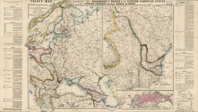
English: Relief (mountain ranges) shown by landform drawings. Hand colored to show existing and proposed boundaries. Shows boundaries of territories acquired by Russia in dark red lines. Title from upper margin of sheet. "Copyright." "Millard Fillmore 1856" signed in ink on portion of cover affixed to sheet verso. Includes text, chronological tables of boundary-related dates for each country, and statistical tables. Title portion of map cover and publisher's map list cover-panel affixed to sheet verso. Available also through the Library of Congress Web site as a raster image. Vault |
||
| Title | Treaty map shewing the boundaries of Russia & the Eastern European states : & the proposed boundary between Russia & Turkey | ||
| Shelf ID | G7001.F2 1856 .W9 | ||
| Date | |||
| Source | https://www.loc.gov/item/2015591079/ | ||
| Author | Wyld, James; Fillmore, Millard | ||
| Permission (Reusing this file) |
|
||
| Other versions |
|
||
| Location | Turkey · Europe, Eastern. · Europe, Eastern · Eastern Europe · Russia. · Turkey. · Russia | ||
| Part of | American Memory · General Maps · Catalog · Geography And Map Division | ||
| Subject | Turkey · Russia · Boundaries · Maps · Territorial Expansion · Europe, Eastern |


Licensing[edit]
|
This is a faithful photographic reproduction of a two-dimensional, public domain work of art. The work of art itself is in the public domain for the following reason:
The official position taken by the Wikimedia Foundation is that "faithful reproductions of two-dimensional public domain works of art are public domain".
This photographic reproduction is therefore also considered to be in the public domain in the United States. In other jurisdictions, re-use of this content may be restricted; see Reuse of PD-Art photographs for details. | ||||
File history
Click on a date/time to view the file as it appeared at that time.
| Date/Time | Thumbnail | Dimensions | User | Comment | |
|---|---|---|---|---|---|
| current | 12:06, 6 June 2018 |  | 10,534 × 5,990 (180.53 MB) | Fæ (talk | contribs) | LOC Maps https://www.loc.gov/item/2015591079/ #21731 |
You cannot overwrite this file.
File usage on Commons
The following page uses this file: