File:Town Mills, Staverton - geograph.org.uk - 1090663.jpg
Jump to navigation
Jump to search
No higher resolution available.
Town_Mills,_Staverton_-_geograph.org.uk_-_1090663.jpg (640 × 429 pixels, file size: 68 KB, MIME type: image/jpeg)
Captions
Captions
Add a one-line explanation of what this file represents
Summary[edit]
| Description |
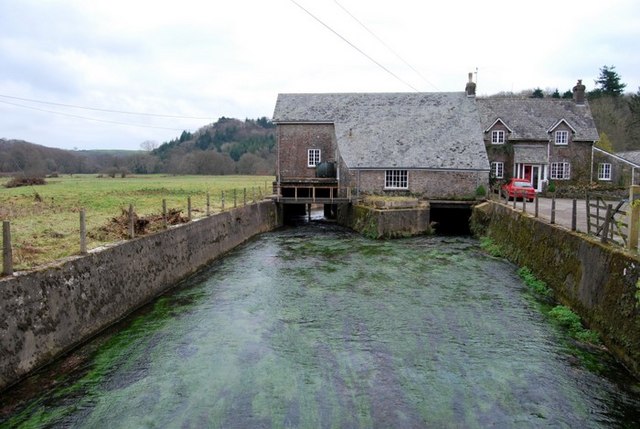
English: Town Mills, Staverton Town Mills near Nappers Crossing. The name Staverton , or Stouretona, means "the village by the stony ford." The ford, an ancient crossing many centuries older than the bridge, was situated by Town Mills, and provided a route from the village to Dartington. |
| Date | |
| Source | From geograph.org.uk |
| Author | Paul Hutchinson |
| Attribution (required by the license) | Paul Hutchinson / Town Mills, Staverton / |
| Camera location | | View this and other nearby images on: OpenStreetMap |
|---|
_heading:135.00&language=en)
| Object location | | View this and other nearby images on: OpenStreetMap |
|---|
_heading:135.00&language=en)
Licensing[edit]

|
This image was taken from the Geograph project collection. See this photograph's page on the Geograph website for the photographer's contact details. The copyright on this image is owned by Paul Hutchinson and is licensed for reuse under the Creative Commons Attribution-ShareAlike 2.0 license.
|
This file is licensed under the Creative Commons Attribution-Share Alike 2.0 Generic license.
Attribution: Paul Hutchinson
- You are free:
- to share – to copy, distribute and transmit the work
- to remix – to adapt the work
- Under the following conditions:
- attribution – You must give appropriate credit, provide a link to the license, and indicate if changes were made. You may do so in any reasonable manner, but not in any way that suggests the licensor endorses you or your use.
- share alike – If you remix, transform, or build upon the material, you must distribute your contributions under the same or compatible license as the original.
File history
Click on a date/time to view the file as it appeared at that time.
| Date/Time | Thumbnail | Dimensions | User | Comment | |
|---|---|---|---|---|---|
| current | 15:46, 24 February 2011 | | 640 × 429 (68 KB) | GeographBot (talk | contribs) | == {{int:filedesc}} == {{Information |description={{en|1=Town Mills, Staverton Town Mills near Nappers Crossing. The name Staverton , or Stouretona, means "the village by the stony ford." The ford, an ancient crossing many centuries older than the bridge, |
You cannot overwrite this file.
File usage on Commons
There are no pages that use this file.