File:Torzított helyszínrajz Rákos.pdf
Jump to navigation
Jump to search

Size of this JPG preview of this PDF file: 800 × 565 pixels. Other resolutions: 320 × 226 pixels | 640 × 452 pixels | 1,024 × 724 pixels | 1,280 × 905 pixels | 2,479 × 1,752 pixels.
Original file (2,479 × 1,752 pixels, file size: 966 KB, MIME type: application/pdf)
Captions
Captions
Add a one-line explanation of what this file represents
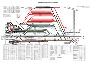
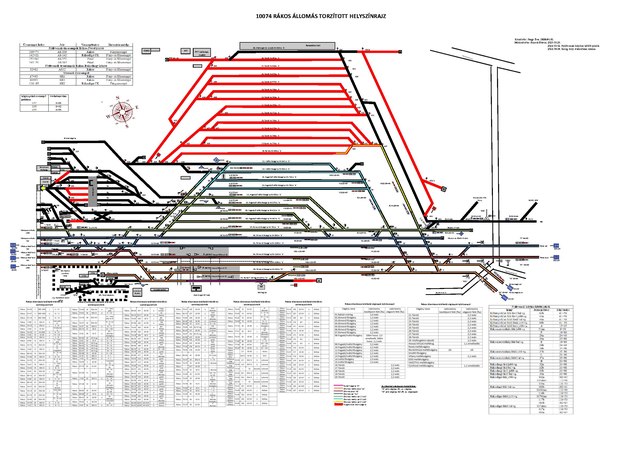
Summary[edit]
| Description |
English: Site plan of track networks of Rákos railway station, Budapest
Magyar: Rákos állomás vágányhálózatának torzított helyszínrajza. A különböző színekkel az egyes állomási áramkörök kerültek jelölésre. |
| Date | |
| Source | https://palyaintranet.mav.hu/forgalom/hsz_/Budapest/FCS-Budapest-Keleti/R%C3%A1kos/Szolg%C3%A1lati_hely_rajzok/Torz%C3%ADtott_helysz%C3%ADnrajz_R%C3%A1kos.pdf |
| Author | Nagy Éva |
Licensing[edit]
This file is licensed under the Creative Commons Attribution-Share Alike 4.0 International license.
- You are free:
- to share – to copy, distribute and transmit the work
- to remix – to adapt the work
- Under the following conditions:
- attribution – You must give appropriate credit, provide a link to the license, and indicate if changes were made. You may do so in any reasonable manner, but not in any way that suggests the licensor endorses you or your use.
- share alike – If you remix, transform, or build upon the material, you must distribute your contributions under the same or compatible license as the original.
File history
Click on a date/time to view the file as it appeared at that time.
| Date/Time | Thumbnail | Dimensions | User | Comment | |
|---|---|---|---|---|---|
| current | 07:15, 26 October 2021 |  | 2,479 × 1,752 (966 KB) | Gyuluskhaa (talk | contribs) | Uploaded a work by Nagy Éva from https://palyaintranet.mav.hu/forgalom/hsz_/Budapest/FCS-Budapest-Keleti/R%C3%A1kos/Szolg%C3%A1lati_hely_rajzok/Torz%C3%ADtott_helysz%C3%ADnrajz_R%C3%A1kos.pdf with UploadWizard |
You cannot overwrite this file.
File usage on Commons
There are no pages that use this file.
File usage on other wikis
The following other wikis use this file:
- Usage on hu.wikipedia.org