File:Topographical atlas of the city of New York, including the annexed territory showing original water courses and made land. NYPL1527362.tiff
Jump to navigation
Jump to search

Size of this JPG preview of this TIF file: 800 × 222 pixels. Other resolutions: 320 × 89 pixels | 640 × 178 pixels | 1,024 × 284 pixels | 1,280 × 355 pixels | 2,560 × 711 pixels | 23,193 × 6,438 pixels.
Original file (23,193 × 6,438 pixels, file size: 427.22 MB, MIME type: image/tiff)
Captions
Captions
Add a one-line explanation of what this file represents
Summary[edit]
| Warning | The original file is very high-resolution. It might not load properly or could cause your browser to freeze when opened at full size. |
|---|
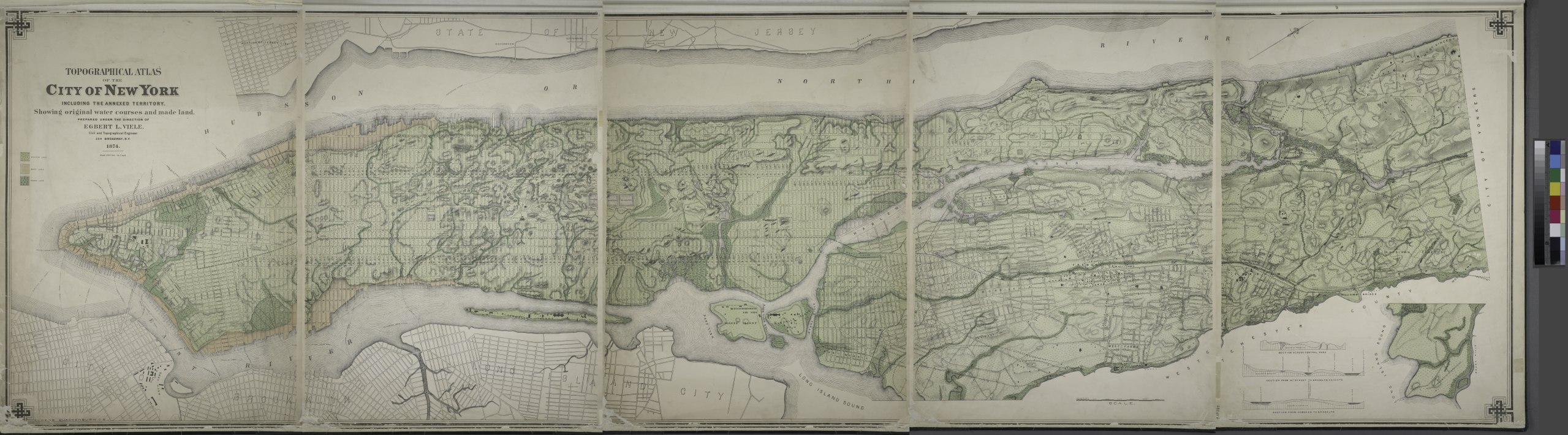
| Description | Topographical atlas of the city of New York, including the annexed territory showing original water courses and made land.; Atlases of New York city. / Topographical atlas of the city of New York, including the annexed territory showing original water courses and made land / prepared under the direction of Egbert L. Viele. | |||||||||||||||||||||||
| Catalogue call number | Map Div.+++ (New York City) (Viele, E. L. Topographical atlas of the city of New York) | |||||||||||||||||||||||
| Date | ||||||||||||||||||||||||
| Source |
http://digitalgallery.nypl.org/nypldigital/dgkeysearchdetail.cfm?imageID=1527362
|
|||||||||||||||||||||||
| Author | Egbert L. (Egbert Ludovicus), 1825-1902 -- Cartographer Viele | |||||||||||||||||||||||
| Permission (Reusing this file) |
From The Lionel Pincus and Princess Firyal Map Division. http://maps.nypl.org
|
|||||||||||||||||||||||
| Other versions |
|
|||||||||||||||||||||||
| Source description | 1 atlas (5 leaves of plates) : 5 col. maps ; 52 x 72 cm. | |||||||||||||||||||||||
| Location | Stephen A. Schwarzman Building / The Lionel Pincus and Princess Firyal Map Division | |||||||||||||||||||||||
| Digital item published | 7-25-2006; updated 3-25-2011 | |||||||||||||||||||||||
| Digital ID | 1527362 | |||||||||||||||||||||||

The making of this file was supported by Wikimedia UK.
To see other files made with the support of Wikimedia UK, please see the category Supported by Wikimedia UK.
|
File history
Click on a date/time to view the file as it appeared at that time.
| Date/Time | Thumbnail | Dimensions | User | Comment | |
|---|---|---|---|---|---|
| current | 13:52, 7 May 2014 | 23,193 × 6,438 (427.22 MB) | Fæ (talk | contribs) | GWToolset: Creating mediafile for Fæ. Tranche 4 -4989 restart @08:55 BST, 7 May 2014 |
You cannot overwrite this file.
File usage on Commons
The following 2 pages use this file: