File:Tierra nveva. NYPL434490.tiff
Jump to navigation
Jump to search

Size of this JPG preview of this TIF file: 740 × 600 pixels. Other resolutions: 296 × 240 pixels | 592 × 480 pixels | 948 × 768 pixels | 1,264 × 1,024 pixels | 2,527 × 2,048 pixels | 5,251 × 4,256 pixels.
Original file (5,251 × 4,256 pixels, file size: 63.98 MB, MIME type: image/tiff)
Captions
Captions
Add a one-line explanation of what this file represents
Summary[edit]
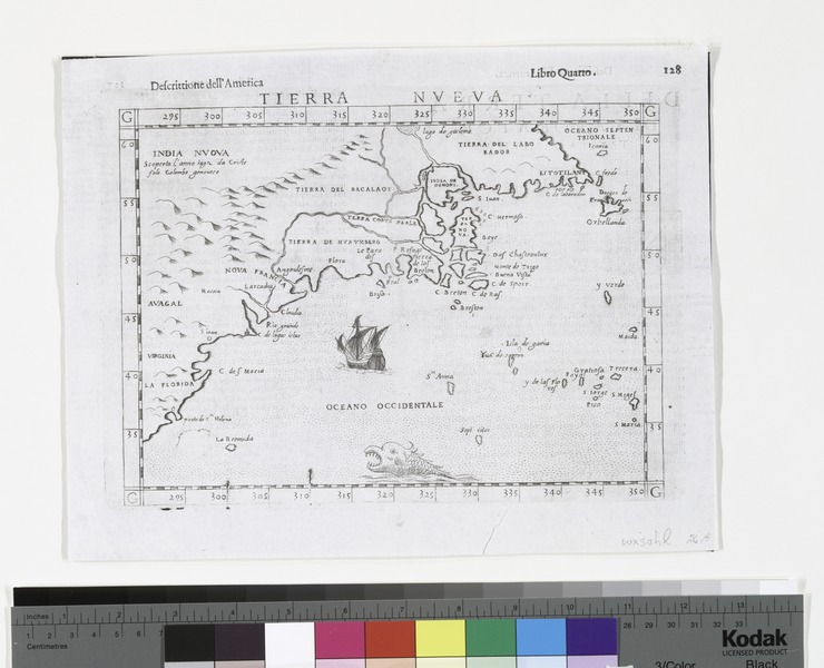
| Description | Tierra nveva.; Lawrence H. Slaughter Collection of English maps, charts, globes, books and atlases / Charts and maps | |||||||||||||||||||||||
| Notes | Appears in Ruscelli's edition of Ptolemy's Geografia di Claudio Tolomeo Alessandrino. 1574. ''Note 2.'') Attributed to Giacomo Gastaldi, with engraving by Giulio and Livio Sanuto--Burden. ''Note 3.'') Lawrence H. Slaughter Collection ; 540a. ''Note 4.'') National Endowment for the Humanities Grant for Access to Early Maps of the Middle Atlantic Seaboard. ''Note 5.'') NYPL copy has ms. "14" in ink in upper right corner. ''Note 6.'') On verso: 31. [Signature:] Hh. ''Note 7.'') Probably 2nd state, based on description in Burden. ''Note 8.'') Relief shown pictorially. ''Note 9.'') Text on verso. | |||||||||||||||||||||||
| Item physical description | 1 map ; 17 x 23 cm. | |||||||||||||||||||||||
| Catalogue call number | Map Div. 97-6365 [LHS 540a] | |||||||||||||||||||||||
| Standard reference | Burden. Mapping of North America, 30 | |||||||||||||||||||||||
| Date | circa 1574 | |||||||||||||||||||||||
| Source |
http://digitalgallery.nypl.org/nypldigital/dgkeysearchdetail.cfm?imageID=434490
|
|||||||||||||||||||||||
| Author | Giacomo, ca. 1500-ca. 1565 -- Cartographer Gastaldi | |||||||||||||||||||||||
| Permission (Reusing this file) |
From The Lionel Pincus and Princess Firyal Map Division. http://maps.nypl.org
|
|||||||||||||||||||||||
| Other versions |
|
|||||||||||||||||||||||
| Location | Stephen A. Schwarzman Building / The Lionel Pincus and Princess Firyal Map Division | |||||||||||||||||||||||
| Digital item published | 2-3-2004; updated 3-25-2011 | |||||||||||||||||||||||
| Digital ID | 434490 | |||||||||||||||||||||||

.jpg)
.jpg)


.jpg)
The making of this file was supported by Wikimedia UK.
To see other files made with the support of Wikimedia UK, please see the category Supported by Wikimedia UK.
|
File history
Click on a date/time to view the file as it appeared at that time.
| Date/Time | Thumbnail | Dimensions | User | Comment | |
|---|---|---|---|---|---|
| current | 03:05, 14 April 2016 |  | 5,251 × 4,256 (63.98 MB) | SteinsplitterBot (talk | contribs) | Bot: Image rotated by 270° |
| 14:41, 7 May 2014 |  | 4,256 × 5,251 (63.94 MB) | Fæ (talk | contribs) | GWToolset: Creating mediafile for Fæ. Tranche 4 -4989 restart @08:55 BST, 7 May 2014 |
You cannot overwrite this file.
File usage on Commons
The following 7 pages use this file:
- File:Tierra nveva (NYPL b13868891-484204).jpg
- File:Tierra nveva (NYPL b15307937-434500)(c).jpg
- File:Tierra nveva (NYPL b15307937-434500).jpg
- File:Tierra nveva (NYPL b15307937-434500).tiff
- File:Tierra nveva (NYPL b15307938-434490)(c).jpg
- File:Tierra nveva (NYPL b15307938-434490).jpg
- File:Tierra nveva (NYPL b15307938-434490).tiff
(c).jpg)
(c).jpg)
Metadata
Categories:
- Extra-Ptolemaic maps of the Americas
- 1570s maps of the Americas
- 1574 maps
- Italian-language maps
- Old maps of Virginia
- Old maps of South Carolina
- 16th-century maps of North Carolina
- Old maps of New Jersey
- Old maps of New York (state)
- Old maps of Connecticut
- Old maps of Rhode Island
- Old maps of Maine
- 16th-century maps of the United States
- Maps of Labrador
- Old maps of Florida