File:This map of Kentucke, LOC 73691819.jpg
Jump to navigation
Jump to search

Size of this preview: 532 × 600 pixels. Other resolutions: 213 × 240 pixels | 426 × 480 pixels | 681 × 768 pixels | 908 × 1,024 pixels | 1,816 × 2,048 pixels | 5,560 × 6,269 pixels.
Original file (5,560 × 6,269 pixels, file size: 4.49 MB, MIME type: image/jpeg)
Captions
Captions
Add a one-line explanation of what this file represents
Summary[edit]
| Description |
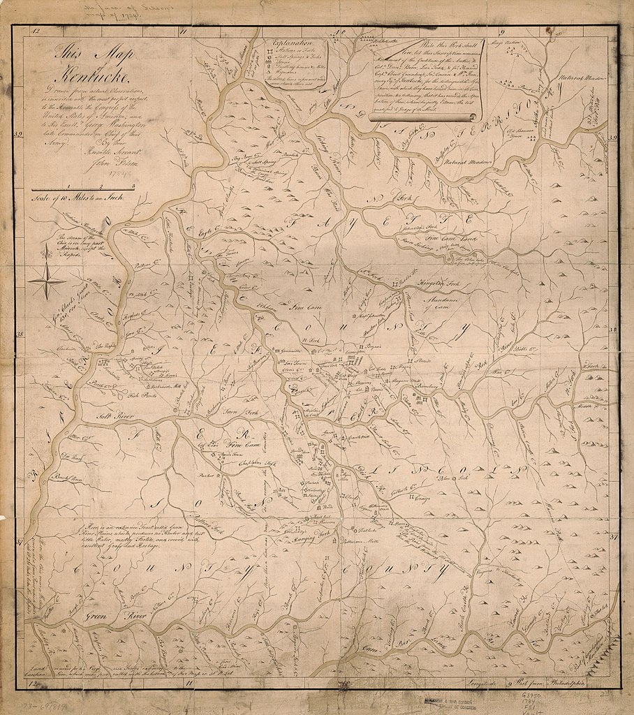
English: Scale 1:633,600; 10 miles to an in. Manuscript, pen-and-ink and watercolor. Relief shown pictorially. Prime meridian: Philadelphia. Copied from Filson's map of 1784. Includes text. LC Maps of North America, 1750-1789, 792 Vault AACR2 |
||
| Title | This map of Kentucke, | ||
| Shelf ID | G3950 1784 .F51 | ||
| Date | |||
| Source | https://www.loc.gov/item/73691819/ | ||
| Author | Filson, John | ||
| Permission (Reusing this file) |
|
||
| Other versions |
|
||
| Location | United States · Kentucky | ||
| Part of | Military Battles And Campaigns · American Memory · Catalog · Geography And Map Division · American Revolution And Its Era: Maps And Charts Of North America And The West Indies, 1750-1789 | ||
| Subject | United States · Maps, Manuscript · Early Works To 1800 · Kentucky |


Licensing[edit]
|
This is a faithful photographic reproduction of a two-dimensional, public domain work of art. The work of art itself is in the public domain for the following reason:
The official position taken by the Wikimedia Foundation is that "faithful reproductions of two-dimensional public domain works of art are public domain".
This photographic reproduction is therefore also considered to be in the public domain in the United States. In other jurisdictions, re-use of this content may be restricted; see Reuse of PD-Art photographs for details. | ||||
File history
Click on a date/time to view the file as it appeared at that time.
| Date/Time | Thumbnail | Dimensions | User | Comment | |
|---|---|---|---|---|---|
| current | 05:09, 19 May 2018 | | 5,560 × 6,269 (4.49 MB) | Fæ (talk | contribs) | LOC Maps https://www.loc.gov/item/73691819/ #11176 |
You cannot overwrite this file.
File usage on Commons
The following page uses this file: