File:Thessaloniki Prefecture, Greece - political map - low detail - numbered.svg
Jump to navigation
Jump to search

Size of this PNG preview of this SVG file: 800 × 566 pixels. Other resolutions: 320 × 226 pixels | 640 × 453 pixels | 1,024 × 724 pixels | 1,280 × 905 pixels | 2,560 × 1,810 pixels | 1,052 × 744 pixels.
Original file (SVG file, nominally 1,052 × 744 pixels, file size: 368 KB)
Captions
Captions
Add a one-line explanation of what this file represents
Summary[edit]
| Description |
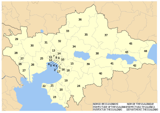
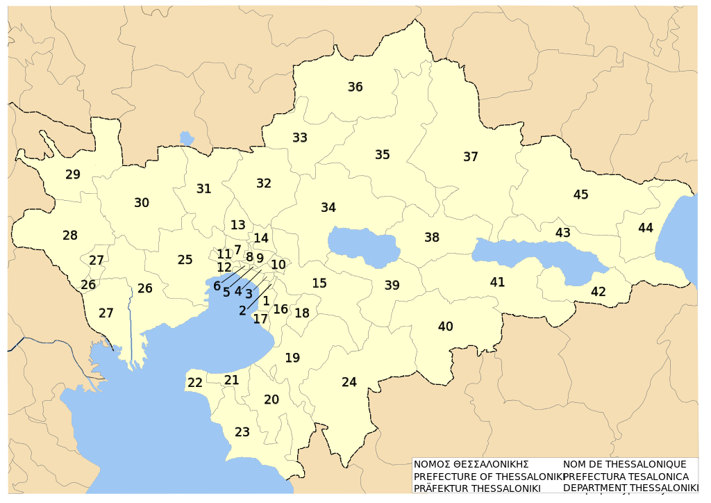
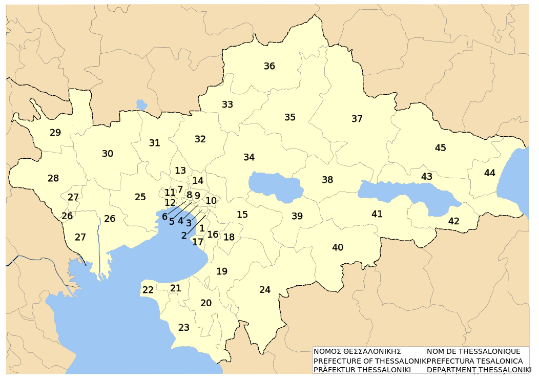
English: w:en:Thessaloniki prefecture, w:en:Greece. Low-detail political map on dimos level. With Numbers.
Deutsch: Präfektur w:de:Thessaloniki (Präfektur), w:de:Griechenland. Niedrig-detaillierte politische Karte auf Ebene der Gemeinden. Nummeriert.
Ellinika: w:el:Νομός Θεσσαλονίκης, w:el:Ελλάδα. Πολιτικός χάρτης με νουμέρα.Ευρετήριο - Index 1 - Δήμος Θεσσαλονίκης - Thessaloniki (Dimos/Municipality) 2 - Δήμος Τριανδρίας - Triandria (Dimos/Municipality) 3 - Δήμος Αγίου Παύλου - Agios Pavlos (Dimos/Municipality) 4 - Δήμος Συκεών - Sykies (Dimos/Municipality) 5 - Δήμος Αμπελοκήπων - Ambelokipi (Dimos/Municipality) 6 - Δήμος Νεαπόλεως - Neapoli (Dimos/Municipality) 7 - Δήμος Ευόσμου - Evosmos (Dimos/Municipality) 8 - Δήμος Σταυρουπόλεως - Stavroupoli (Dimos/Municipality) 9 - Δήμος Πολίχνης - Polichni (Dimos/Municipality) 10 - Κοινότητα Πεύκων - Pefka (Kinotita/Community) 11 - Δήμος Ελευθερίου-Κορδελιού - Eleftherio-Kordelio (Dimos/Municipality) 12 - Δήμος Μενεμένης - Menemeni (Dimos/Municipality) 13 - Δήμος Ωραιοκάστρου - Oreokastro (Dimos/Municipality) 14 - Κοινότητα Ευκαρπίας - Efkarpia (Kinotita/Community) 15 - Δήμος Χορτιάτη - Chortiatis (Dimos/Municipality) 16 - Δήμος Πυλαίας - Pylea (Dimos/Municipality) 17 - Δήμος Καλαμαριάς - Kalamaria (Dimos/Municipality) 18 - Δήμος Πανοράματος - Panorama (Dimos/Municipality) 19 - Δήμος Θέρμης - Thermi (Dimos/Municipality) 20 - Δήμος Μίκρας - Mikra (Dimos/Municipality) 21 - Δήμος Θερμαϊκού - Thermaikos (Dimos/Municipality) 22 - Δήμος Μηχανιώνας - Michaniona (Dimos/Municipality) 23 - Δήμος Επανομής - Epanomi (Dimos/Municipality) 24 - Δήμος Βασιλικών - Vasilika (Dimos/Municipality) 25 - Δήμος Εχεδώρου - Echedoros (Dimos/Municipality) 26 - Δήμος Χαλάστρας - Chalastra (Dimos/Municipality) 27 - Δήμος Αξιού - Axios (Dimos/Municipality) 28 - Δήμος Χαλκηδόνος - Chalkidona (Dimos/Municipality) 29 - Δήμος Κουφαλίων - Koufalia (Dimos/Municipality) 30 - Δήμος Αγίου Αθανασίου - Agios Athanasios (Dimos/Municipality) 31 - Δήμος Καλλιθέας - Kallithea (Dimos/Municipality) 32 - Δήμος Μυγδονίας - Mygdonia (Dimos/Municipality) 33 - Δήμος Ασσήρου - Assiros (Dimos/Municipality) 34 - Δήμος Λαγκαδά - Langadas (Dimos/Municipality) 35 - Δήμος Βερτίσκου - Vertsikos (Dimos/Municipality) 36 - Δήμος Λαχανά - Lachanas (Dimos/Municipality) 37 - Δήμος Σοχού - Sochos (Dimos/Municipality) 38 - Δήμος Εγνατίας - Egnatia (Dimos/Municipality) 39 - Δήμος Κορώνειας - Koronia (Dimos/Municipality) 40 - Δήμος Καλλινδοίων - Kallindia (Dimos/Municipality) 41 - Δήμος Απολλωνίας - Apollonia (Dimos/Municipality) 42 - Δήμος Μαδύτου - Madytos (Dimos/Municipality) 43 - Δήμος Ρεντίνας - Rendina (Dimos/Municipality) 44 - Δήμος Αγίου Γεωργίου - Agios Georgios (Dimos/Municipality) 45 - Δήμος Αρέθουσας - Arethousa (Dimos/Municipality) |
| Date | |
| Source | self-made after specimen to be found at Official political map of municipalities and municipal districts of Thessaloniki prefecture. Published by Prefecture's administration. Accessed on 2007-08-30 |
| Author | Christaras A |
| Other versions |
Derivative works of this file: |
Licensing[edit]
I, the copyright holder of this work, hereby publish it under the following licenses:

|
Permission is granted to copy, distribute and/or modify this document under the terms of the GNU Free Documentation License, Version 1.2 or any later version published by the Free Software Foundation; with no Invariant Sections, no Front-Cover Texts, and no Back-Cover Texts. A copy of the license is included in the section entitled GNU Free Documentation License. |
This file is licensed under the Creative Commons Attribution 3.0 Unported license.
- You are free:
- to share – to copy, distribute and transmit the work
- to remix – to adapt the work
- Under the following conditions:
- attribution – You must give appropriate credit, provide a link to the license, and indicate if changes were made. You may do so in any reasonable manner, but not in any way that suggests the licensor endorses you or your use.
You may select the license of your choice.
File history
Click on a date/time to view the file as it appeared at that time.
| Date/Time | Thumbnail | Dimensions | User | Comment | |
|---|---|---|---|---|---|
| current | 15:55, 31 August 2007 | | 1,052 × 744 (368 KB) | Christaras A (talk | contribs) | {{Information |Description=English: w:en:Thessaloniki prefecture, w:en:Greece. Low-detail political map on dimos level. With Numbers.<br>Deutsch: Präfektur w:de:Thessaloniki (Präfektur), w:de:Griechenland. Niedrig-detaillierte politische |
| 15:24, 31 August 2007 |  | 1,052 × 744 (368 KB) | Christaras A (talk | contribs) | {{Information |Description=English: w:en:Thessaloniki prefecture, w:en:Greece. Low-detail political map on municipality level. Numbered.<br>Deutsch: Präfektur w:de:Thessaloniki (Präfektur), w:de:Griechenland. Niedrig-detaillierte politis | |
| 15:06, 31 August 2007 |  | 1,052 × 744 (365 KB) | Christaras A (talk | contribs) | {{Information |Description=English: w:en:Thessaloniki prefecture, w:en:Greece. Low-detail political map on dimos level. With Numbers.<br>Deutsch: Präfektur w:de:Thessaloniki (Präfektur), w:de:Griechenland. Niedrig-detaillierte politische |
You cannot overwrite this file.
File usage on Commons
The following page uses this file:
File usage on other wikis
The following other wikis use this file:
- Usage on el.wikipedia.org
- Usage on hr.wikipedia.org
- Usage on it.wikipedia.org
- Usage on ja.wikipedia.org
- Usage on la.wikipedia.org
- Usage on lt.wikipedia.org