File:The national atlas of the United States of America. LOC 79654043-15.tif
Jump to navigation
Jump to search

Size of this JPG preview of this TIF file: 800 × 534 pixels. Other resolutions: 320 × 214 pixels | 640 × 427 pixels | 1,024 × 684 pixels | 1,280 × 854 pixels | 2,560 × 1,709 pixels | 8,193 × 5,469 pixels.
Original file (8,193 × 5,469 pixels, file size: 128.2 MB, MIME type: image/tiff)
Captions
Captions
Add a one-line explanation of what this file represents
Summary[edit]
| Description |
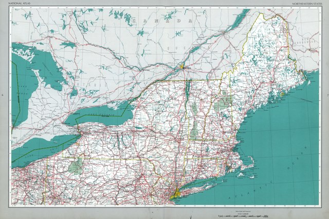
English: Scales vary. Six transparent overlays in envelope inserted. Signed by William T. Pecora, Under Secretary of Interior, W.A. Radlinski, Associate Director, U.S.G.S., Arch C. Gerlach, Chief Geographer, and William B. Overstreet, Chief National Atlas Project and is number 13 of 14 copies. Available also through the Library of Congress Web site as a raster image. Copy 13; Exchange; Exchange with Dr. Walter W. Ristow and his son Stephen F. Ristow. Acquisitions control no. 97-31 Copies 1 and 4 NOS |
||
| Title | The national atlas of the United States of America. | ||
| Shelf ID | G1200 .U57 1970 G1200 .U57 1970 G1200 .U57 1970 G1200 .U57 1970 G1200 .U57 1970 G1200 .U57 1970 G1200 .U57 1970 G1200 .U57 1970 G1200 .U57 1970 G1200 .U57 1970 G1200 .U57 1970 G1200 .U57 1970 | ||
| Parent | https://www.loc.gov/resource/g3701gm.gct00013/ | ||
| Sheet title | Northeastern States | ||
| Date | |||
| Source | https://www.loc.gov/item/79654043/ | ||
| Author | Geological Survey (U.S.); Gerlach, Arch C. | ||
| Permission (Reusing this file) |
|
||
| Other versions |
|
||
| Location | United States | ||
| Part of | American Memory · Catalog · Geography And Map Division · Cultural Landscapes | ||
| Subject | United States · Maps · Statistics · Census |


Licensing[edit]
| This work is from the Library of Congress. According to the library, there are no known copyright restrictions on the use of this work. |  |
File history
Click on a date/time to view the file as it appeared at that time.
| Date/Time | Thumbnail | Dimensions | User | Comment | |
|---|---|---|---|---|---|
| current | 23:42, 5 June 2018 |  | 8,193 × 5,469 (128.2 MB) | Fæ (talk | contribs) | LOC Maps multisheet https://www.loc.gov/item/79654043/ sheet 15 of 247 #13386 |
You cannot overwrite this file.
File usage on Commons
The following page uses this file: