File:The coast of New England (2674898811).jpg

Original file (1,412 × 2,000 pixels, file size: 1.77 MB, MIME type: image/jpeg)
Captions
Captions
Summary[edit]
.jpg&action=edit§ion=1)
| Description |
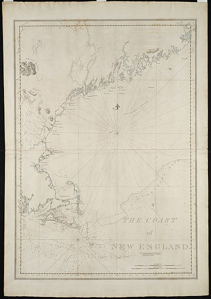
Zoom into this map at maps.bpl.org. Author: Des Barres, Joseph F. W. Publisher: J.F.W. Des Barres Date: 1781 Nov. 1. Location: New England Scale: Scale not given. Call Number: G3722.C6 1781.D4 This survey of Boston Harbor, first published in 1775 in Des Barress Atlantic Neptune, was the pre-eminent chart of the harbor produced in the 18th century. It was used by the Royal Navy during the American Revolution, and long after that conflict by American and English merchants. The chart was based on surveys by George Callendar, master of His Majestys Ship Romney, stationed in Boston Harbor in 1769. Displayed here is the fourth state of the chart which depicts the inland topography in great detail. Roads, taverns, streams and farmhouses are shown throughout the countryside. |
| Date | |
| Source |
|
| Author | Joseph Frederick Wallet DesBarres, relying on surveys by George Callendar |
Licensing[edit]
.jpg&action=edit§ion=2)
|
This work is in the public domain in its country of origin and other countries and areas where the copyright term is the author's life plus 100 years or fewer. | |
| This file has been identified as being free of known restrictions under copyright law, including all related and neighboring rights. | |
File history
Click on a date/time to view the file as it appeared at that time.
| Date/Time | Thumbnail | Dimensions | User | Comment | |
|---|---|---|---|---|---|
| current | 04:37, 21 August 2013 | | 1,412 × 2,000 (1.77 MB) | File Upload Bot (Magnus Manske) (talk | contribs) | Transferred from Flickr by User:tm |
You cannot overwrite this file.
File usage on Commons
There are no pages that use this file.
.jpg&oldid=719295549)