File:Texas proposed boundaries.svg
Jump to navigation
Jump to search

Size of this PNG preview of this SVG file: 621 × 600 pixels. Other resolutions: 248 × 240 pixels | 497 × 480 pixels | 795 × 768 pixels | 1,060 × 1,024 pixels | 2,120 × 2,048 pixels | 1,475 × 1,425 pixels.
Original file (SVG file, nominally 1,475 × 1,425 pixels, file size: 697 KB)
Captions
Captions
Add a one-line explanation of what this file represents
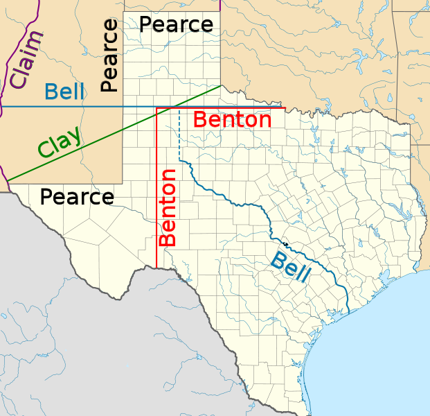
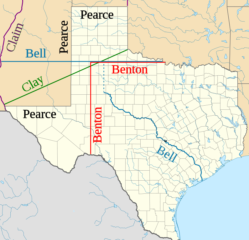
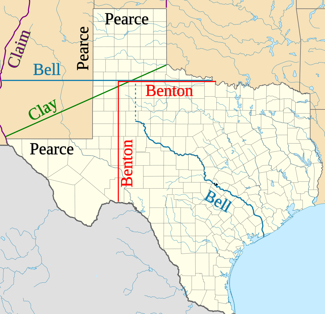
| Description | Northern and western boundaries of Texas proposed by various Senators in the Compromise of 1850 debate |
| Date | (UTC) |
| Source | |
| Author |
|
| This is a retouched picture, which means that it has been digitally altered from its original version. Modifications: Proposed boundaries for Compromise of 1850. The original can be viewed here: USA Texas location map.svg:
|
I, the copyright holder of this work, hereby publish it under the following licenses:
This file is licensed under the Creative Commons Attribution 3.0 Unported license.
- You are free:
- to share – to copy, distribute and transmit the work
- to remix – to adapt the work
- Under the following conditions:
- attribution – You must give appropriate credit, provide a link to the license, and indicate if changes were made. You may do so in any reasonable manner, but not in any way that suggests the licensor endorses you or your use.

|
Permission is granted to copy, distribute and/or modify this document under the terms of the GNU Free Documentation License, Version 1.2 or any later version published by the Free Software Foundation; with no Invariant Sections, no Front-Cover Texts, and no Back-Cover Texts. A copy of the license is included in the section entitled GNU Free Documentation License. |
You may select the license of your choice.
Original upload log[edit]
This image is a derivative work of the following images:
- File:USA_Texas_location_map.svg licensed with Cc-by-3.0, GFDL
- 2009-06-17T20:30:36Z Alexrk2 1500x1484 (711918 Bytes) enh
- 2009-06-07T13:05:09Z Alexrk 1500x1484 (571429 Bytes) water bodies 1:10mio
- 2009-06-06T21:43:21Z Alexrk 1500x1484 (870861 Bytes) GeneralizationDistance = 2px
- 2009-06-06T17:41:11Z Alexrk 1500x1485 (1550930 Bytes) == Beschreibung == {{Information |Description= {{de|Positionskarte von [[:de:Texas|Texas]], [[:de:USA|USA]]}} Quadratische Plattkarte, N-S-Streckung 120 %. Geographische Begrenzung der Karte: * N: 36.8° N * S: 25.5° N * W:
Uploaded with derivativeFX
File history
Click on a date/time to view the file as it appeared at that time.
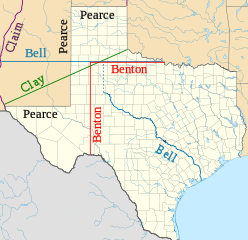
| Date/Time | Thumbnail | Dimensions | User | Comment | |
|---|---|---|---|---|---|
| current | 00:11, 29 January 2010 | | 1,475 × 1,425 (697 KB) | JWB (talk | contribs) | Identify more of Pearce and Benton lines |
| 00:03, 29 January 2010 |  | 1,475 × 1,425 (696 KB) | JWB (talk | contribs) | Identify final proposal as Pearce's | |
| 23:52, 28 January 2010 |  | 1,475 × 1,425 (696 KB) | JWB (talk | contribs) | Tweaks | |
| 23:50, 28 January 2010 |  | 1,475 × 1,400 (696 KB) | JWB (talk | contribs) | {{Information |Description=Northern and western boundaries of Texas proposed by various Senators in the Compromise of 1850 debate |Source=*File:USA_Texas_location_map.svg |Date=2010-01-28 23:47 (UTC) |Author=*File:USA_Texas_location_map.svg: [ |
You cannot overwrite this file.
File usage on Commons
The following page uses this file:
File usage on other wikis
The following other wikis use this file:
- Usage on af.wikipedia.org
- Usage on azb.wikipedia.org
- Usage on cy.wikipedia.org
- Usage on en.wikipedia.org
- Usage on fy.wikipedia.org
- Usage on id.wikipedia.org
- Usage on it.wikipedia.org
- Usage on ja.wikipedia.org
- Usage on kk.wikipedia.org
- Usage on mk.wikipedia.org
- Usage on ms.wikipedia.org
- Usage on pt.wikipedia.org
- Usage on ro.wikipedia.org
- Usage on ru.wikipedia.org
- Usage on th.wikipedia.org
- Usage on uz.wikipedia.org
- Usage on vi.wikipedia.org
- Usage on www.wikidata.org