File:Temblor Range, California (21394649620).jpg

Original file (4,000 × 3,000 pixels, file size: 2.43 MB, MIME type: image/jpeg)
Captions
Captions
Summary[edit]
.jpg&action=edit§ion=1)
| Description |
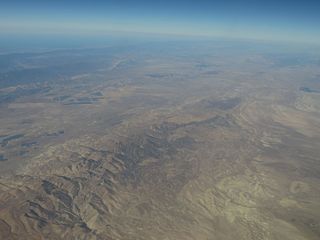
The Temblor Range is a mountain range within the California Coast Ranges, at the southwestern extremity of the San Joaquin Valley in California in the United States. It runs in a northwest-southeasterly direction along the borders of Kern County and San Luis Obispo County. The name of the range is from the Spanish word for "earthquake" (terremoto). The San Andreas Fault Zone runs parallel to the range at the base of its western slope, on the eastern side of the Carrizo Plain, while the Antelope Plain, location of the enormous Midway Sunset, South Belridge, and Cymric oil fields, lies to the northeast. Peaks within the Temblor Range average about 3500 ft (1,100 m) above sea level. The highest point is McKittrick Summit at 4,331 ft (1,320 m), located in the center of the range about 35 mi (56 km) west of Bakersfield.[3] The summit on State Route 58, which crosses the range, is at 3,750 feet (1,140 m) above sea level. The Temblor Range and surrounding region contains extensive outcrops of the Monterey Formation (Miocene age, about 20 to 9 million years). Rocks from the Monterey formation consist mostly of silicate shales and porcellanite (silica derived from fossil plankton in an intermediate to deep-water marine setting). Fossils and sediments from the Monterey Formation show that the Carrizo Plain region was a marine basin with shallow to intermediate depths (marine waters covered the southern San Joaquin Valley region). Marine sediments younger than about 9 million years are not preserved in the Carrizo Plain National Monument area, but they occur throughout the Kettleman Hills region (about 60 miles (97 km) north of the park). The Pliocene-age Etchegoin Formation contains marine fossils to about 4 million years old. Fossils of the Etchegoin Formation are supporting evidence that the Coast Ranges and the Temblor Range are young, having been uplifted mostly during the Pleistocene Epoch (or Quaternary Period) in the past several million years. Much of that ongoing uplift is due to tectonics associated with the San Andreas Fault and other fault systems in the region. During the Pleistocene, sometime more recently than 1.8 million years ago, an enormous block of the Temblor Range – a swath of Monterey shale more than six miles (10 km) long, a mile across, and over 2,000 feet (610 m) thick, about three cubic miles of rock in all – slid down the northeastern side of the range, covering a distance of approximately three miles and descending 2,000 feet (610 m). This mass movement completely covered the McKittrick Oil Field, giving it a highly unusual geology for an oil field, as the petroleum deposits in most oil fields are in structural or stratigraphic traps; this field is capped by an enormous mass of rock that moved off of the adjacent mountain range. en.wikipedia.org/wiki/Temblor_Range en.wikipedia.org/wiki/Wikipedia:Text_of_Creative_Commons_... |
| Date | |
| Source | Temblor Range, California |
| Author | Ken Lund from Reno, Nevada, USA |
| Camera location | | View this and other nearby images on: OpenStreetMap |
|---|
.jpg¶ms=035.533786_N_-119.631556_E_globe:Earth_type:camera_source:Flickr_&language=en)
Licensing[edit]
.jpg&action=edit§ion=2)
- You are free:
- to share – to copy, distribute and transmit the work
- to remix – to adapt the work
- Under the following conditions:
- attribution – You must give appropriate credit, provide a link to the license, and indicate if changes were made. You may do so in any reasonable manner, but not in any way that suggests the licensor endorses you or your use.
- share alike – If you remix, transform, or build upon the material, you must distribute your contributions under the same or compatible license as the original.
| This image was originally posted to Flickr by Ken Lund at https://flickr.com/photos/75683070@N00/21394649620. It was reviewed on 4 December 2015 by FlickreviewR and was confirmed to be licensed under the terms of the cc-by-sa-2.0. |
File history
Click on a date/time to view the file as it appeared at that time.
| Date/Time | Thumbnail | Dimensions | User | Comment | |
|---|---|---|---|---|---|
| current | 04:49, 4 December 2015 | | 4,000 × 3,000 (2.43 MB) | INeverCry (talk | contribs) | Transferred from Flickr via Flickr2Commons |
You cannot overwrite this file.
File usage on Commons
There are no pages that use this file.
.jpg&oldid=860143306)