File:TTC subway map 2023.svg
Jump to navigation
Jump to search

Size of this PNG preview of this SVG file: 800 × 531 pixels. Other resolutions: 320 × 213 pixels | 640 × 425 pixels | 1,024 × 680 pixels | 1,280 × 850 pixels | 2,560 × 1,701 pixels | 3,056 × 2,030 pixels.
Original file (SVG file, nominally 3,056 × 2,030 pixels, file size: 348 KB)
Captions
Captions
Add a one-line explanation of what this file represents


Summary[edit]
| Description |
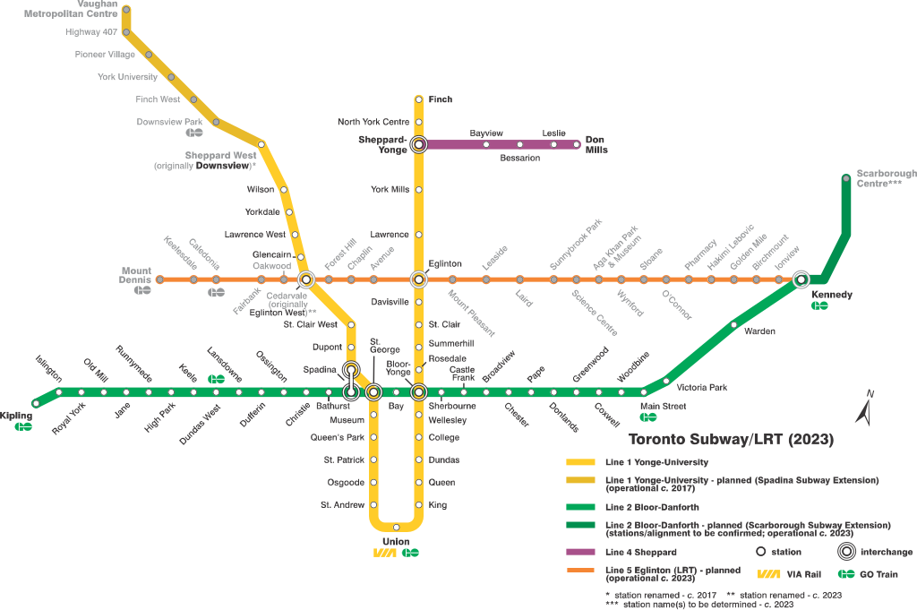
English: TTC subway/RT map (as of 2023); self-made, likely representation of lines/stations that have been approved, funded, or under construction; based on map at https://www.ttc.ca/PDF/Maps/Subway_Map.pdf and (esp. Line 5) inspired by future map (p. 28) at http://www.ttc.ca/About_the_TTC/Commission_reports_and_information/Commission_meetings/2013/October_23/Reports/New_Wayfinding_Standards_Presentation.pdf |
| Date | |
| Source | Own work |
| Author | Craftwerker |
Licensing[edit]
I, the copyright holder of this work, hereby publish it under the following license:
This file is licensed under the Creative Commons Attribution-Share Alike 4.0 International license.
- You are free:
- to share – to copy, distribute and transmit the work
- to remix – to adapt the work
- Under the following conditions:
- attribution – You must give appropriate credit, provide a link to the license, and indicate if changes were made. You may do so in any reasonable manner, but not in any way that suggests the licensor endorses you or your use.
- share alike – If you remix, transform, or build upon the material, you must distribute your contributions under the same or compatible license as the original.
File history
Click on a date/time to view the file as it appeared at that time.
| Date/Time | Thumbnail | Dimensions | User | Comment | |
|---|---|---|---|---|---|
| current | 09:00, 4 May 2016 | | 3,056 × 2,030 (348 KB) | Craftwerker (talk | contribs) | tw: greyed out future Eglinton W stn name |
| 04:29, 22 March 2016 |  | 3,056 × 2,030 (348 KB) | Craftwerker (talk | contribs) | updated Line 5 Eglinton station names & Line 2 NE extension into Scarborough (tw) | |
| 04:22, 22 March 2016 |  | 3,150 × 2,118 (348 KB) | Craftwerker (talk | contribs) | updated Line 5 Eglinton station names & Line 2 NE extension into Scarborough | |
| 20:21, 30 April 2015 |  | 3,150 × 2,100 (333 KB) | Craftwerker (talk | contribs) | tw | |
| 13:48, 27 April 2015 |  | 3,150 × 2,100 (333 KB) | Craftwerker (talk | contribs) | User created page with UploadWizard |
You cannot overwrite this file.
File usage on Commons
The following 15 pages use this file:
- User:*Youngjin/GTA transit/2015 April 21-30
- User:*Youngjin/GTA transit/2016 March 21-31
- User:*Youngjin/GTA transit/2016 May 1-10
- User:Chumwa/OgreBot/Potential transport maps/2016 March 21-31
- User:Chumwa/OgreBot/Potential transport maps/2016 May 1-10
- User:Chumwa/OgreBot/Public transport information/2015 April 21-30
- User:Chumwa/OgreBot/Public transport information/2016 March 21-31
- User:Chumwa/OgreBot/Public transport information/2016 May 1-10
- User:Chumwa/OgreBot/Transport Maps/2015 April 21-30
- User:Chumwa/OgreBot/Transport Maps/2016 March 21-31
- User:Chumwa/OgreBot/Transport Maps/2016 May 1-10
- User:Chumwa/OgreBot/Travel and communication maps/2016 March 21-31
- User:Chumwa/OgreBot/Travel and communication maps/2016 May 1-10
- User talk:AquitaneHungerForce
- File:TTC subway map - 2023.svg (file redirect)
File usage on other wikis
The following other wikis use this file:
- Usage on en.wikipedia.org
- Usage on zh.wikipedia.org