File:Spruce Tree Point, Administrative Building, Mesa Verde Administrative District, Cortez, Montezuma County, CO HABS COLO,42-CORT.V,5C- (sheet 4 of 4).tif
Jump to navigation
Jump to search

Size of this JPG preview of this TIF file: 800 × 545 pixels. Other resolutions: 320 × 218 pixels | 640 × 436 pixels | 1,024 × 698 pixels | 1,280 × 872 pixels | 2,560 × 1,744 pixels | 14,400 × 9,809 pixels.
Original file (14,400 × 9,809 pixels, file size: 438 KB, MIME type: image/tiff)
Captions
Captions
Add a one-line explanation of what this file represents
Summary[edit]
| Warning | The original file is very high-resolution. It might not load properly or could cause your browser to freeze when opened at full size. |
|---|
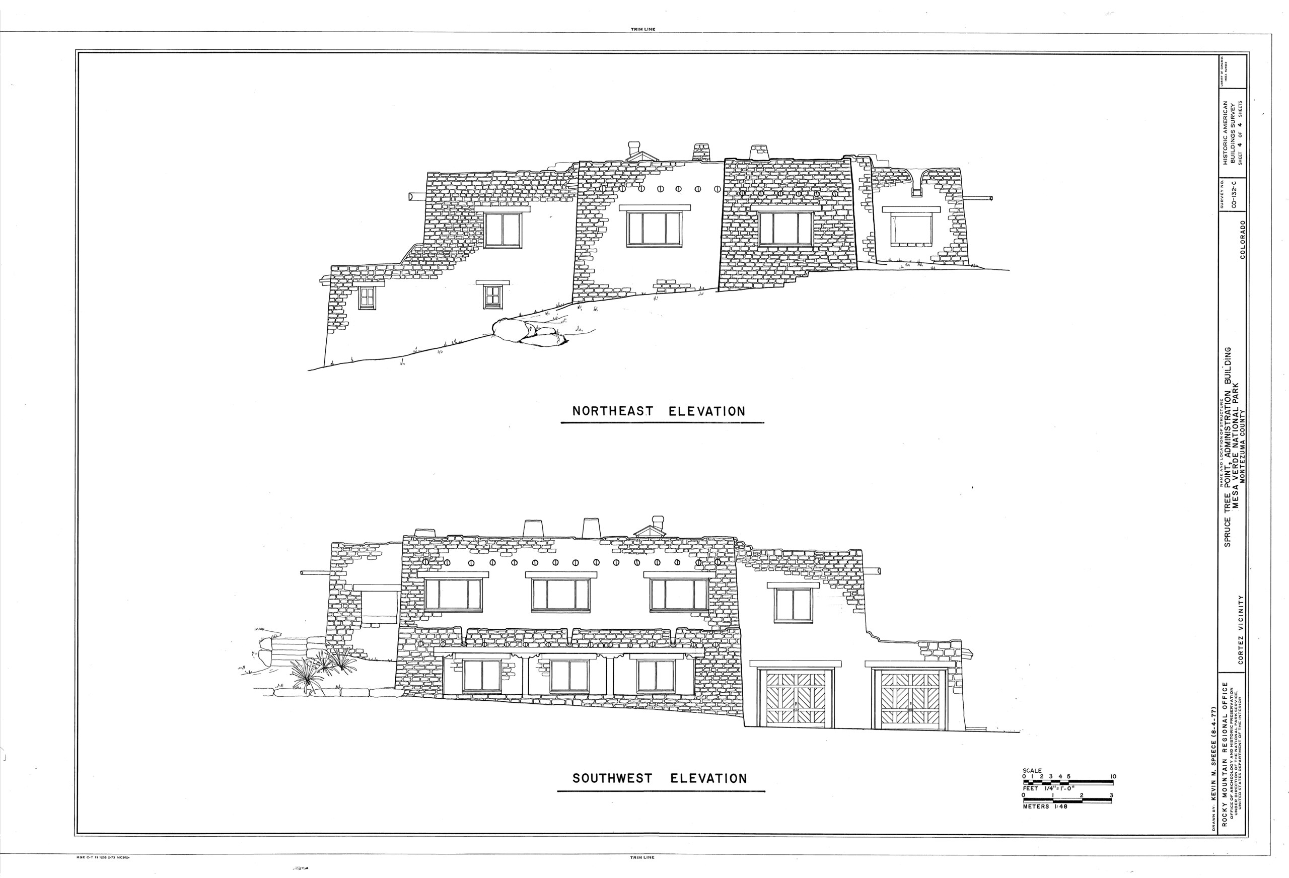
| HABS COLO,42-CORT.V,5C- (sheet 4 of 4) - Spruce Tree Point, Administrative Building, Mesa Verde Administrative District, Cortez, Montezuma County, CO | ||||
|---|---|---|---|---|
| Photographer |
Related names:
|
|||
| Title |
HABS COLO,42-CORT.V,5C- (sheet 4 of 4) - Spruce Tree Point, Administrative Building, Mesa Verde Administrative District, Cortez, Montezuma County, CO |
|||
| Depicted place | Colorado; Montezuma County; Cortez | |||
| Date | Documentation compiled after 1933 | |||
| Dimensions | 24 x 36 in. (D size) | |||
| Current location |
Library of Congress Prints and Photographs Division Washington, D.C. 20540 USA http://hdl.loc.gov/loc.pnp/pp.print |
|||
| Accession number |
HABS COLO,42-CORT.V,5C- (sheet 4 of 4) |
|||
| Credit line |
|
|||
| Notes |
|
|||
| References |
|
|||
| Source | https://www.loc.gov/pictures/item/co0767.sheet.00004a | |||
| Permission (Reusing this file) |
|
|||
| Other versions |
.png) .png) .png) .png) |
|||

| Object location | | View this and other nearby images on: OpenStreetMap |
|---|
File history
Click on a date/time to view the file as it appeared at that time.
| Date/Time | Thumbnail | Dimensions | User | Comment | |
|---|---|---|---|---|---|
| current | 17:28, 6 July 2014 |  | 14,400 × 9,809 (438 KB) | Fæ (talk | contribs) | GWToolset: Creating mediafile for Fæ. HABS 06 July 2014 (611:700) |
You cannot overwrite this file.
File usage on Commons
The following 2 pages use this file:
- File:- Spruce Tree Point, Administrative Building, Mesa Verde Administrative District, Cortez, Montezuma County, CO HABS COLO,42-CORT.V,5C- (sheet 4 of 4).tif (file redirect)
- File:Spruce Tree Point, Administrative Building, Mesa Verde Administrative District, Cortez, Montezuma County, CO HABS COLO,42-CORT.V,5C- (sheet 4 of 4).tif