File:Specialkarte des Karwendelgebirges.jpg
Jump to navigation
Jump to search

Size of this preview: 679 × 600 pixels. Other resolutions: 272 × 240 pixels | 544 × 480 pixels | 870 × 768 pixels | 1,160 × 1,024 pixels | 2,320 × 2,048 pixels | 11,201 × 9,890 pixels.
Original file (11,201 × 9,890 pixels, file size: 41.64 MB, MIME type: image/jpeg)
Captions
Captions
Add a one-line explanation of what this file represents
Summary
[edit]
| Warning | The original file is very high-resolution. It might not load properly or could cause your browser to freeze when opened at full size. |
|---|
| Description |
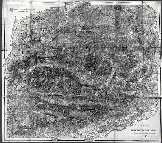
Specialkarte des Karwendelgebirges aus Zeitschrift des Deutschen und Oesterreichischen Alpenvereins 1888 Band 19 Hinterau Thal (Hinterautal), Karwendeltal, Rissbachtal, Falzthurntal (rechts) und oberes Isartal (ganz links). |
||||||||||||||||||||||
| Date | |||||||||||||||||||||||
| Source | austrian literature online - obere Hälfte, austrian literature online - untere Hälfte, | ||||||||||||||||||||||
| Author |
|
||||||||||||||||||||||
| Other versions |
 |
||||||||||||||||||||||
|
The author died in 1931, so this work is in the public domain in its country of origin and other countries and areas where the copyright term is the author's life plus 80 years or fewer. This work is in the public domain in the United States because it was published (or registered with the U.S. Copyright Office) before January 1, 1929. | |
| This file has been identified as being free of known restrictions under copyright law, including all related and neighboring rights. | |
| Annotations | This image is annotated: View the annotations at Commons |
File history
Click on a date/time to view the file as it appeared at that time.
| Date/Time | Thumbnail | Dimensions | User | Comment | |
|---|---|---|---|---|---|
| current | 15:05, 19 November 2016 | | 11,201 × 9,890 (41.64 MB) | Kogo (talk | contribs) |
You cannot overwrite this file.
File usage on Commons
The following 4 pages use this file: