File:Karwendel Karte Hugo Petters.TIF

Original file (3,774 × 3,252 pixels, file size: 5.51 MB, MIME type: image/tiff)
Captions
Captions
Summary[edit]
| Description |
English: Map of Karwendel, Tyrol, Austria. By Hugo Petters, based on Maps by DAV and OeAV (Deutscher Alpenverein, Österreichischer Alpenverein), published in: Heinrich Schwaiger: Schwaiger's Führer durch das Karwendelgebirge. J. Lindauersche Buchandlung, München 1907
Deutsch: Karte des Karwendelgebirges, Tirol. Von Hugo Pettersauf Basis von Karten des DAV and OeAV (Deutscher Alpenverein, Österreichischer Alpenverein) gezeichnet, veröfentlicht in: Heinrich Schwaiger: Schwaiger's Führer durch das Karwendelgebirge. J. Lindauersche Buchandlung, München 1907 |
||||||||||||||||||||||
| Date | |||||||||||||||||||||||
| Source | Heinrich Schwaiger: Schwaiger's Führer durch das Karwendelgebirge | ||||||||||||||||||||||
| Author |
|
||||||||||||||||||||||
| Other versions |
 |
||||||||||||||||||||||
Licensing[edit]
|
This work is in the public domain in its country of origin and other countries and areas where the copyright term is the author's life plus 70 years or fewer.
| |
| This file has been identified as being free of known restrictions under copyright law, including all related and neighboring rights. | |
File history
Click on a date/time to view the file as it appeared at that time.
| Date/Time | Thumbnail | Dimensions | User | Comment | |
|---|---|---|---|---|---|
| current | 13:05, 25 September 2011 |  | 3,774 × 3,252 (5.51 MB) | McZusatz (talk | contribs) | thumb fix |
| 12:49, 25 September 2011 | 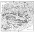 | 12,172 × 10,490 (4.61 MB) | McZusatz (talk | contribs) | thumb fix | |
| 10:43, 9 November 2009 |  | 12,172 × 10,490 (4.57 MB) | Svíčková (talk | contribs) | {{Information |Description={{en|1=Map of Karwendel, Tyrol, Austria. By Hugo Petters, based on Maps by DAV and OeAV (Deutscher Alpenverein, Österreichischer Alpenverein), published in: Heinrich Schwaiger: Schwaiger's Führer durch |
You cannot overwrite this file.
File usage on Commons
The following page uses this file: