File:Slavs Vojvodina01 map sr.png
Jump to navigation
Jump to search

Size of this preview: 732 × 600 pixels. Other resolutions: 293 × 240 pixels | 586 × 480 pixels | 1,020 × 836 pixels.
Original file (1,020 × 836 pixels, file size: 67 KB, MIME type: image/png)
Captions
Captions
Add a one-line explanation of what this file represents
Summary[edit]
| Description |
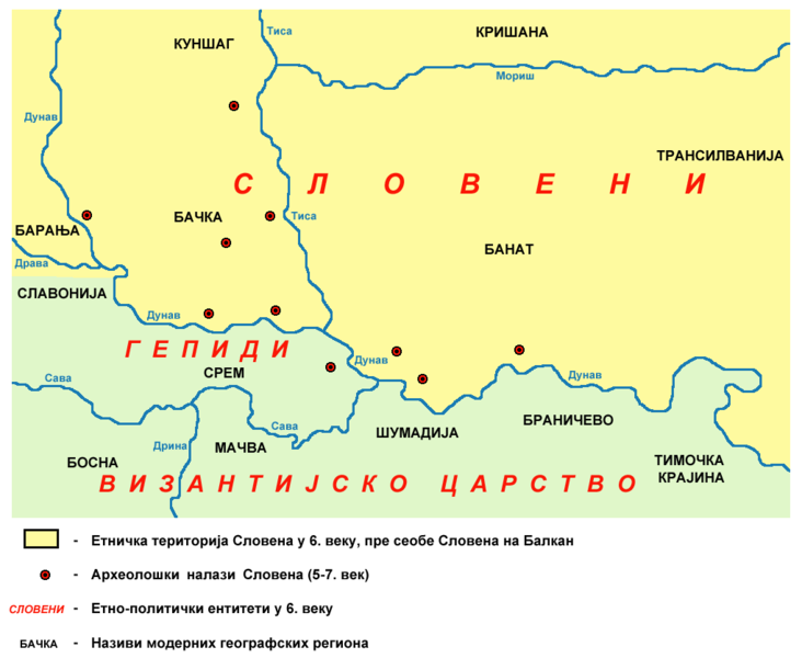
English: historical map of old Slavs in Vojvodina (Banat, Bačka and Syrmia) in the 6th century, before Slavic migration to the Balkans - Serbian language version.
Српски / srpski: историјска карта која приказује старе Словене на подручју Војводине (Баната, Бачке и Срема) у 6. веку, пре насељавања Словена на Балкан - верзија на српском језику. |
| Date | 23 June 2009 (original upload date) |
| Source | No machine-readable source provided. Own work assumed (based on copyright claims). |
| Author | No machine-readable author provided. PANONIAN assumed (based on copyright claims). |
References[edit]
- Radmilo Petrović, Vojvodina - petnaest milenijuma kulturne istorije, Beograd, 2003.
Licensing[edit]
self made map by user:PANONIAN
| I, the copyright holder of this work, release this work into the public domain. This applies worldwide. In some countries this may not be legally possible; if so: I grant anyone the right to use this work for any purpose, without any conditions, unless such conditions are required by law. |
File history
Click on a date/time to view the file as it appeared at that time.
| Date/Time | Thumbnail | Dimensions | User | Comment | |
|---|---|---|---|---|---|
| current | 10:59, 23 June 2009 | | 1,020 × 836 (67 KB) | PANONIAN (talk | contribs) | ==Description== *'''English''': historical map of old Slavs in Vojvodina (Banat, Bačka and Syrmia) in the 6th century, before Slavic migration to the Balkans - Serbian language version. *'''Serbian''': историјска карта која прика� |
You cannot overwrite this file.
File usage on Commons
There are no pages that use this file.
File usage on other wikis
The following other wikis use this file:
- Usage on mk.wikipedia.org
- Usage on sh.wikipedia.org
- Usage on sr.wikipedia.org
Categories:
- Maps of the history of Vojvodina
- Maps of the history of Serbia in the Early Middle Ages
- Historical maps of ethnic groups in Vojvodina
- Maps of ethnic groups in Serbia
- Maps of the history of Banat
- Maps of the history of Bačka
- Maps of the history of Syrmia
- Maps of Slavic tribes
- Maps of the Gepids
- Maps of the history of Romania in the Middle Ages
- Serbian-language maps