File:Sketch plan for landscaping the grounds of the President's House, ca. 1802-05. LOC 88693237.tif
Jump to navigation
Jump to search

Size of this JPG preview of this TIF file: 479 × 600 pixels. Other resolutions: 192 × 240 pixels | 383 × 480 pixels | 613 × 768 pixels | 818 × 1,024 pixels | 1,635 × 2,048 pixels | 5,040 × 6,312 pixels.
Original file (5,040 × 6,312 pixels, file size: 91.02 MB, MIME type: image/tiff)
Captions
Captions
Add a one-line explanation of what this file represents
Summary[edit]
| Description |
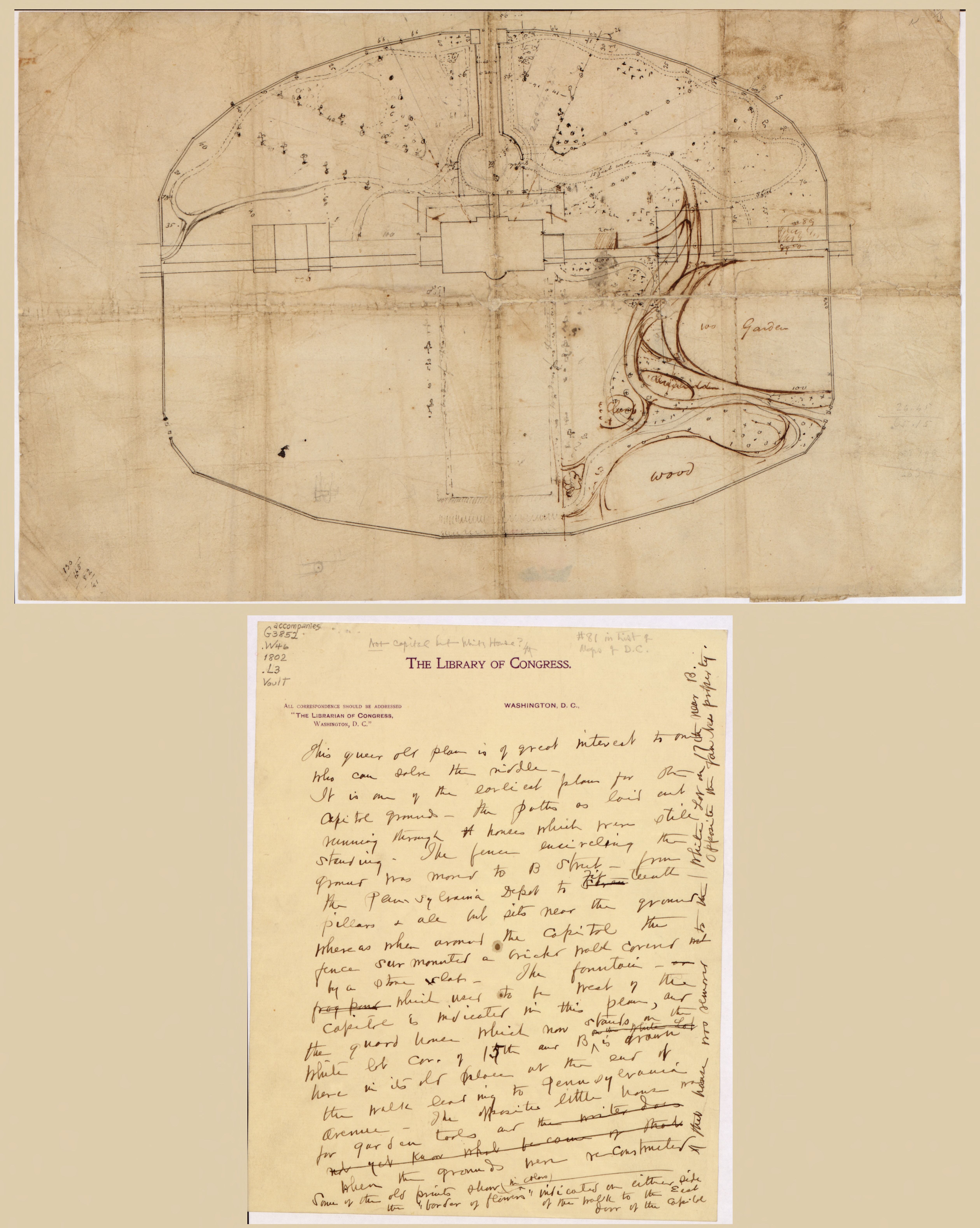
English: Title from accompanying photocopied pages. Drawn by different hands. Attributed variously to Benjamin Latrobe, Robert Mills, and Thomas Jefferson. Pen-and-ink with lead pencil additions. Soiled, wrinkled, fold-lined, and torn. Accompanied by handwritten letter in ink, headed "The Library of Congress," that erroneously identifies plan as "Capitol Grounds." [1] sheet ; 26 x 21 cm. Also accompanied by photocopied pages from book : The President's House, a history / by William Seale. Washington, D.C. : White House Historical Association, 1986. [3] leaves : ill., map ; 22 x 28 cm. Available also through the Library of Congress Web site as a raster image. Phillips. Washington 81 Vault DCP |
||
| Title | [Sketch plan for landscaping the grounds of the President's House, ca. 1802-05]. | ||
| Shelf ID | G3852.W46 1802 .L3 | ||
| Date | |||
| Source | https://www.loc.gov/item/88693237/ | ||
| Author | Latrobe, Benjamin Henry; Mills, Robert; Jefferson, Thomas | ||
| Permission (Reusing this file) |
|
||
| Other versions |
|
||
| Location | United States · Washington D.C. · District Of Columbia · Washington | ||
| Part of | American Memory · Cities And Towns · Catalog · Geography And Map Division | ||
| Subject | Maps, Manuscript · Washington (D.C.) · Landscape Architecture · Washington · United States · Maps · District Of Columbia · Design · Gardens · Manuscript Maps · White House (Washington, D.C.) |


Licensing[edit]
|
This is a faithful photographic reproduction of a two-dimensional, public domain work of art. The work of art itself is in the public domain for the following reason:
The official position taken by the Wikimedia Foundation is that "faithful reproductions of two-dimensional public domain works of art are public domain".
This photographic reproduction is therefore also considered to be in the public domain in the United States. In other jurisdictions, re-use of this content may be restricted; see Reuse of PD-Art photographs for details. | ||||
File history
Click on a date/time to view the file as it appeared at that time.
| Date/Time | Thumbnail | Dimensions | User | Comment | |
|---|---|---|---|---|---|
| current | 06:32, 15 May 2018 |  | 5,040 × 6,312 (91.02 MB) | Fæ (talk | contribs) | LOC Maps https://www.loc.gov/item/88693237/ #375 |
You cannot overwrite this file.
File usage on Commons
The following 3 pages use this file: