File:Sea of Marmara and the Turkish Straits - UBBasel Map 1578 Kartenslg AA 90 Grecia (page 1 crop).tiff
Jump to navigation
Jump to search

Size of this JPG preview of this TIF file: 762 × 600 pixels. Other resolutions: 305 × 240 pixels | 610 × 480 pixels | 976 × 768 pixels | 1,280 × 1,007 pixels | 2,560 × 2,015 pixels | 2,775 × 2,184 pixels.
Original file (2,775 × 2,184 pixels, file size: 17.36 MB, MIME type: image/tiff)
Captions
Captions
Add a one-line explanation of what this file represents
Summary[edit]
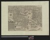
| Title |
Videbis totius Greciae limites diusios per montes flumina & maria nominib. hodiernis, ad hunc modun |
|||||||||||||||||||||||
| Description |
Videbis totius Greciae limites diusios per montes flumina & maria nominib. hodiernis, ad hunc modun |
|||||||||||||||||||||||
| Date | ||||||||||||||||||||||||
| Source | 10.3931/e-rara-12912 : Info: Kartenportal.CH | |||||||||||||||||||||||
| Creator |
|
|||||||||||||||||||||||
| Permission (Reusing this file) |
|
|||||||||||||||||||||||
| Geotemporal data | ||||||||||||||||||||||||
| Scale | Ca. 1:1 800 000 | |||||||||||||||||||||||
| Bounding box |
|
|||||||||||||||||||||||
| Georeferencing | If inappropriate please set warp_status = skip to hide. | |||||||||||||||||||||||
| Bibliographic data | ||||||||||||||||||||||||
| Language | lat | |||||||||||||||||||||||
| Printed by |
Antwerpen, Gerard de Jode |
|||||||||||||||||||||||
| Archival data | ||||||||||||||||||||||||
| Collection |
|
|||||||||||||||||||||||
| Accession number |
Basel UB, Kartenslg AA 90 |
|||||||||||||||||||||||
| Dimensions | height: 38 cm (14.9 in); width: 51 cm (20 in) | |||||||||||||||||||||||
| Medium | Kupferstich | |||||||||||||||||||||||
| Notes | Titel- und Erläuterungskartusche (33 Zeilen) unten links / Kompassrose oberhalb der Titelkartusche / Basiert auf einer Karte von Pirro Ligorio von 1561 (Karrow 1993:354) | |||||||||||||||||||||||
| Other versions | ||||||||||||||||||||||||


File history
Click on a date/time to view the file as it appeared at that time.
| Date/Time | Thumbnail | Dimensions | User | Comment | |
|---|---|---|---|---|---|
| current | 21:27, 20 June 2020 |  | 2,775 × 2,184 (17.36 MB) | Balkanique (talk | contribs) | File:UBBasel Map 1578 Kartenslg AA 90 Grecia.tiff cropped 77 % horizontally, 78 % vertically using CropTool with precise mode. |
You cannot overwrite this file.
File usage on Commons
The following 2 pages use this file: