File:Regional accreditation map.svg
Jump to navigation
Jump to search

Size of this PNG preview of this SVG file: 800 × 495 pixels. Other resolutions: 320 × 198 pixels | 640 × 396 pixels | 1,024 × 633 pixels | 1,280 × 791 pixels | 2,560 × 1,583 pixels | 959 × 593 pixels.
Original file (SVG file, nominally 959 × 593 pixels, file size: 37 KB)
Captions
Captions
Add a one-line explanation of what this file represents
Summary[edit]
| Description |
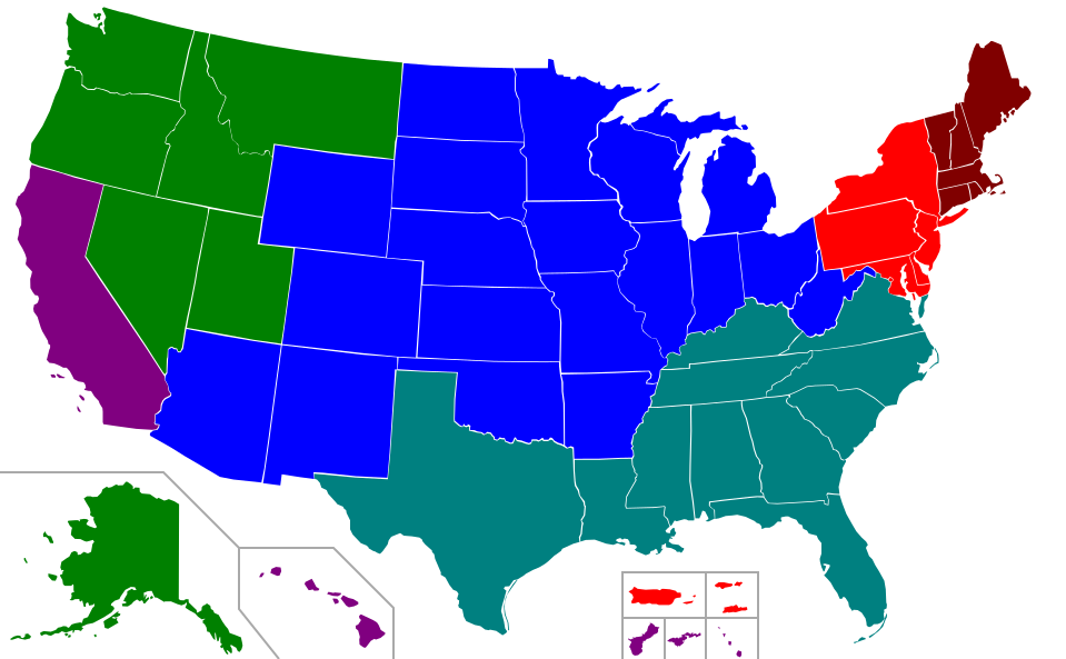
A map of the regional accreditation agencies. Legend: |
||
| Date | (UTC) | ||
| Source |
This file was derived from: Blank USA, w territories.svg: |
||
| Author | File:Blank USA, w territories.svg: Lokal_Profil | ||
| Other versions |
Derivative works of this file:
All the below are of the states (and DC) only.
|
||
| SVG development |
|
Licensing[edit]
I, the copyright holder of this work, hereby publish it under the following licenses:
| This file is licensed under the Creative Commons Attribution-Share Alike 3.0 Unported license. | ||
| ||
| This licensing tag was added to this file as part of the GFDL licensing update. |

|
Permission is granted to copy, distribute and/or modify this document under the terms of the GNU Free Documentation License, Version 1.2 or any later version published by the Free Software Foundation; with no Invariant Sections, no Front-Cover Texts, and no Back-Cover Texts. A copy of the license is included in the section entitled GNU Free Documentation License. |
You may select the license of your choice.
Original upload log[edit]
This image is a derivative work of the following images:
- File:Blank_USA,_w_territories.svg licensed with Cc-by-sa-3.0-migrated, GFDL
- 2009-01-30T01:59:59Z Hoshie 959x593 (98189 Bytes) Reverted to version as of 23:58, 14 January 2009 - rv myself; DC can be seen clearly.
- 2009-01-18T23:34:42Z Hoshie 959x593 (102341 Bytes) Put DC in an inset; fixed Tutuila (American Samoa)
- 2009-01-14T23:58:05Z Lokal Profil 959x593 (98189 Bytes) Code cleanup and removed stroke from Guam and American Samoa
- 2009-01-13T05:19:51Z Hoshie 959x593 (101361 Bytes) re did Guam and added American Samoa
- 2007-12-02T16:08:45Z Lokal Profil 959x593 (88960 Bytes) {{Information |Description=A blank map of the United States including Puerto Rico, Guam, the United States Virgin Islands, and the Northern Mariana Islands. |Source=This version was made by [[:User:Lokal_Profil|Lokal_Profil]]
Uploaded with derivativeFX
File history
Click on a date/time to view the file as it appeared at that time.
| Date/Time | Thumbnail | Dimensions | User | Comment | |
|---|---|---|---|---|---|
| current | 08:19, 12 July 2016 | | 959 × 593 (37 KB) | Newfraferz87 (talk | contribs) | Slash code |
| 21:19, 27 May 2013 |  | 959 × 593 (113 KB) | Presidentman (talk | contribs) | == {{int:filedesc}} == {{Information |Description=A map of the regional accreditation agencies.<br>'''Legend:'''{{Legend|red|MSA}}{{Legend|#800000|NEASC}}{{Legend|blue|NCA}}{{Legend|green|NAC}}{{Legend|#008080|SACS}}{{Legen... |
You cannot overwrite this file.
File usage on Commons
The following page uses this file:
File usage on other wikis
The following other wikis use this file:
- Usage on he.wikipedia.org
- Usage on sh.wikipedia.org
- Asocijacija koledža i škola saveznih država srednjeg Atlantika
- Asocijacija škola i koledža Nove Engleske
- Asocijacija koledža i škola sjevernih i centralnih saveznih država
- Sjeverozapadna komisija za univerzitete i koledže
- Asocijacija koledža i škola američkog Juga
- Zapadna asocijacija škola i koledža
- Šablon:Regionalna akreditacija univerziteta u SAD-u