File:Red Fort drawing.svg
Jump to navigation
Jump to search

Size of this PNG preview of this SVG file: 301 × 599 pixels. Other resolutions: 120 × 240 pixels | 241 × 480 pixels | 386 × 768 pixels | 515 × 1,024 pixels | 1,029 × 2,048 pixels | 1,000 × 1,989 pixels.
Original file (SVG file, nominally 1,000 × 1,989 pixels, file size: 321 KB)
Captions
Captions
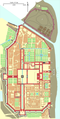
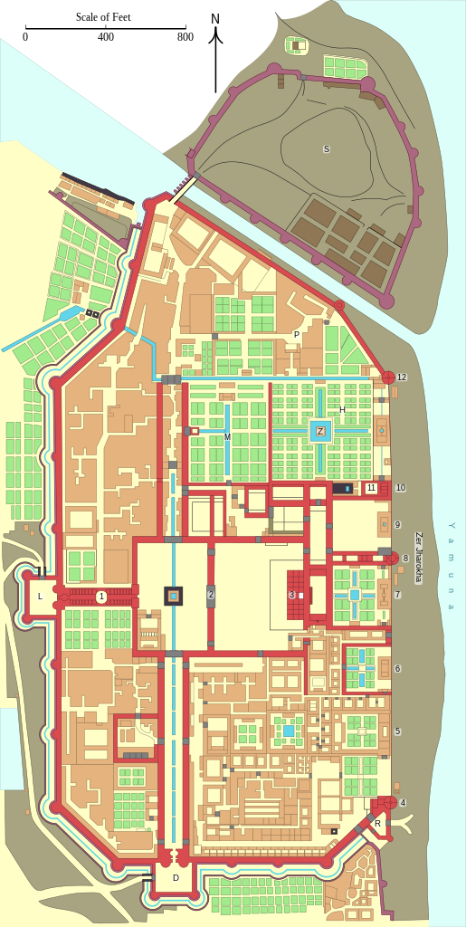
Plan of the Red Fort in Delhi before 1857.
Summary[edit]
| Description |
English: Floor plan of the Red Fort in Delhi before 1857.
|
||
| Date | |||
| Source |
Own work |
||
| Author | Goran tek-en | ||
| Permission (Reusing this file) |
This file is licensed under the Creative Commons Attribution-Share Alike 4.0 International license. Attribution: Goran tek-en
|
||
| Other versions |
|
||
| SVG development | This W3C-invalid vector image was created with Inkscape, or with something else.
|


| Object location | | View this and other nearby images on: OpenStreetMap |
|---|


| Annotations | This image is annotated: View the annotations at Commons |

|
This image has been assessed under the valued image criteria and is considered the most valued image on Commons within the scope: Floor plan of the Red Fort in Delhi before 1857.. You can see its nomination here. |
File history
Click on a date/time to view the file as it appeared at that time.
| Date/Time | Thumbnail | Dimensions | User | Comment | |
|---|---|---|---|---|---|
| current | 18:51, 18 November 2021 | | 1,000 × 1,989 (321 KB) | Goran tek-en (talk | contribs) | ppi to 96, optimized |
| 14:34, 3 March 2014 |  | 1,000 × 1,989 (676 KB) | Goran tek-en (talk | contribs) | Minor changes | |
| 16:54, 21 February 2014 |  | 1,000 × 1,989 (677 KB) | Goran tek-en (talk | contribs) | Larger nominally size | |
| 14:15, 21 February 2014 |  | 497 × 989 (665 KB) | Goran tek-en (talk | contribs) | User created page with UploadWizard |
You cannot overwrite this file.
File usage on Commons
The following 7 pages use this file:
- User:Goran tek-en/Gallery/2014
- User:Goran tek-en/discussions/2021
- Commons:Quality images/Subject/Non photographic media
- Commons:Quality images candidates/Archives June 28 2021
- Commons:Valued image candidates/Red Fort drawing.svg
- Commons:Valued images by topic/Objects/Other
- File:Handbooktravelle00john 0356.jpg
File usage on other wikis
The following other wikis use this file:
- Usage on de.wikipedia.org
- Usage on no.wikipedia.org
- Usage on or.wikipedia.org