File:Quehanna Reactor and Jet Bunkers 1958 labels.png
Jump to navigation
Jump to search

Size of this preview: 796 × 599 pixels. Other resolutions: 319 × 240 pixels | 638 × 480 pixels | 1,020 × 768 pixels | 1,280 × 964 pixels | 1,688 × 1,271 pixels.
Original file (1,688 × 1,271 pixels, file size: 1.77 MB, MIME type: image/png)
Captions
Captions
Add a one-line explanation of what this file represents
Summary[edit]
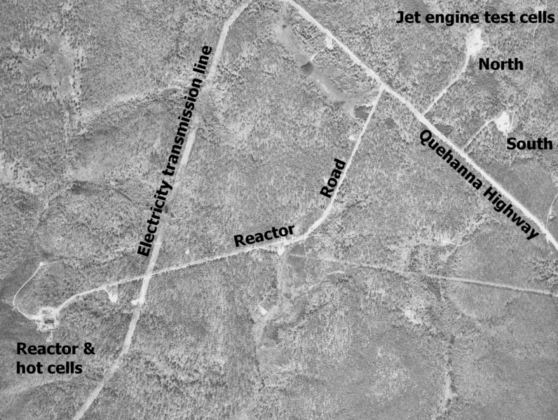
| Description | Aerial photo of w:Quehanna Wild Area and the surrounding Moshannon and Elk State Forests in Clearfield, ELk, and Cameron Counties, Pennsylvania in the United States. North is up. The Quehanna Highway crosses diagonally from top left to the middle of the right side. Three roads leave Quehanna Highway in the right half of the picture. They are, from left to right: 1) Reactor Road, which curves southwest to the nuclear reactor building. 2) and 3) Short roads running north to bunkers for testing jet engines - the westernmost and northernmost of these was the center of the 16-sided polygon controlled by Curtiss-Wright Corp. Both bunkers are now in Wykoff Run Natural Area. A power line clear cut zig-zags from top to bottom, crossing Reactor Road and the highway. | |||
| Date | Photo taken 10/19/1958 | |||
| Source | File is here at the Penn Pilot website, "a project sponsored by the Pennsylvania Geological Survey, is an online library of digital historical aerial photography for the Commonwealth of Pennsylvania." Original file name was "cameron_101958_apo_2v_31.jpg", cropped and labeled by Ruhrfisch (talk) | |||
| Author | According to this, "The photos were produced by the United States Department of Agriculture, Agricultural Adjustment Administration (now known as the Farm Service Agency)." | |||
| Permission (Reusing this file) |
|
|||
| Other versions |
 |
Licensing[edit]
This image or file is a work of a United States Department of Agriculture employee, taken or made as part of that person's official duties. As a work of the U.S. federal government, the image is in the public domain.
|
 |
File history
Click on a date/time to view the file as it appeared at that time.
| Date/Time | Thumbnail | Dimensions | User | Comment | |
|---|---|---|---|---|---|
| current | 13:52, 8 March 2010 | | 1,688 × 1,271 (1.77 MB) | Ruhrfisch (talk | contribs) | == {{int:filedesc}} == {{Information |Description= Aerial photo of w:Quehanna Wild Area and the surrounding Moshannon and Elk State Forests in Clearfield, ELk, and Cameron Counties, Pennsylvania in the United States. North is up. The Quehanna Highway |
You cannot overwrite this file.
File usage on Commons
There are no pages that use this file.
File usage on other wikis
The following other wikis use this file:
- Usage on en.wikipedia.org