Category:Quehanna Wild Area
Jump to navigation
Jump to search
State-owned wildlife area in Pennsylvania, US  | |||||
| Upload media | |||||
| Instance of | |||||
|---|---|---|---|---|---|
| Location | Pennsylvania | ||||
 | |||||
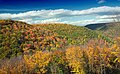
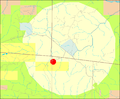
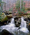
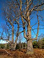
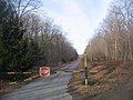
Quehanna Wild Area is a 48,186-acre (75 sq mi; 195 sq km) wildlife area in Elk and Moshannon State Forests in Cameron, Clearfield, and Elk counties in the U.S. state of Pennsylvania.
Subcategories
This category has the following 4 subcategories, out of 4 total.
Media in category "Quehanna Wild Area"
The following 88 files are in this category, out of 88 total.
-
 2-Grinder Use Test Cut.jpg 640 × 480; 80 KB
-
 Benezette Township Flaky.jpg 3,120 × 3,058; 9.19 MB
-
 Big Spring Draft (1) (30216442196).jpg 2,900 × 4,326; 10.2 MB
-
 Big Spring Draft (10) (30165646601).jpg 5,184 × 3,456; 19.36 MB
-
 Big Spring Draft (2) (30216216626).jpg 5,184 × 3,456; 19.12 MB
-
 Big Spring Draft (3) (29995807940).jpg 5,184 × 3,456; 18.69 MB
-
 Big Spring Draft (4) (30257423486).jpg 3,408 × 2,998; 11.23 MB
-
 Big Spring Draft (5) (30136087622).jpg 5,184 × 3,157; 19.71 MB
-
 Big Spring Draft (6) (29620656904).jpg 5,184 × 3,456; 24.36 MB
-
 Big Spring Draft (7) (30165845841).jpg 4,475 × 2,933; 12.4 MB
-
 Big Spring Draft (8) (30165915601).jpg 5,184 × 3,456; 19.32 MB
-
 Big Spring Draft (9) (30136158842).jpg 5,184 × 3,456; 21.65 MB
-
 Boundary Post (1) (18293135055).jpg 2,944 × 5,184; 10.61 MB
-
 Boundary Post (2) (18105367340).jpg 2,774 × 5,184; 10 MB
-
 Cloud Shadows (8064434465).jpg 5,028 × 3,179; 11.08 MB
-
 Converged (1) (11275631103).jpg 4,509 × 3,351; 13.84 MB
-
 Converged (2) (11275483065).jpg 4,561 × 3,426; 14.63 MB
-
 Curtiss Wright Rocket Engine.jpg 871 × 966; 560 KB
-
 Flickr - Nicholas T - Beaver Run Shallow Water Impoundment (1).jpg 4,608 × 3,312; 8.28 MB
-
 Flickr - Nicholas T - Beaver Run Shallow Water Impoundment (2).jpg 4,608 × 3,456; 5.97 MB
-
 Flickr - Nicholas T - Beaver Run Shallow Water Impoundment (3).jpg 3,456 × 4,608; 5.62 MB
-
 Flickr - Nicholas T - Beaver Run Shallow Water Impoundment (4).jpg 4,608 × 3,456; 8.06 MB
-
 Flickr - Nicholas T - Beaver Run Shallow Water Impoundment (5).jpg 4,608 × 3,456; 10.28 MB
-
 Flickr - Nicholas T - Converged (1).jpg 4,509 × 3,351; 13.08 MB
-
 Flickr - Nicholas T - Converged (2).jpg 4,561 × 3,426; 12.88 MB
-
 Flickr - Nicholas T - Heath Barrens.jpg 4,608 × 3,456; 9.76 MB
-
 Flickr - Nicholas T - Oddity.jpg 2,735 × 3,746; 9.05 MB
-
 Flickr - Nicholas T - Paige Run (1).jpg 3,799 × 4,548; 9.2 MB
-
 Flickr - Nicholas T - Paige Run (2).jpg 3,456 × 4,608; 9.05 MB
-
 Flickr - Nicholas T - Paige Run Gorge (Revisited) (1).jpg 4,608 × 3,456; 10.3 MB
-
 Flickr - Nicholas T - Paige Run Gorge (Revisited) (2).jpg 3,456 × 3,915; 8.29 MB
-
 Flickr - Nicholas T - Quehanna Highway.jpg 4,608 × 2,381; 6.29 MB
-
 Flickr - Nicholas T - Relic.jpg 2,304 × 3,072; 6.82 MB
-
 Furrows (8064443652).jpg 5,184 × 3,213; 12.99 MB
-
 Gore Vista Trail (1) (30176641992).jpg 4,963 × 3,185; 14.4 MB
-
 Gore Vista Trail (2) (29661788474).jpg 5,184 × 3,456; 14.11 MB
-
 Kunes Camp.jpg 3,608 × 1,975; 5.63 MB
-
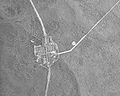 Piper and Quehanna Wild Area Aerial 1958 crop.jpg 945 × 758; 521 KB
-
 Piper and Quehanna WIld Area Aerial 1958.jpg 1,883 × 1,874; 1.06 MB
-
 Quehanna Beaver Run Blind.jpg 2,048 × 1,536; 1.1 MB
-
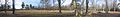
 Quehanna Beaver Run panorama.jpg 8,457 × 1,374; 6.8 MB
-
 Quehanna Beaver Run Pond.jpg 1,997 × 1,483; 1.9 MB
-
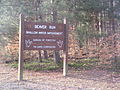 Quehanna Beaver Run Sign.jpg 2,048 × 1,536; 1.32 MB
-
 Quehanna Birches.jpg 2,048 × 1,536; 1.48 MB
-
 Quehanna Bunker 2.jpg 3,427 × 1,485; 3.31 MB
-
 Quehanna Bunker roof pano.jpg 12,872 × 1,268; 13.68 MB
-
 Quehanna Bunker.jpg 2,048 × 1,536; 1.07 MB
-
 Quehanna Highway.jpg 2,048 × 1,536; 733 KB
-
 Quehanna Hoover Farm Blind.jpg 2,836 × 1,523; 3.27 MB
-
 Quehanna Hoover Farm panorama.jpg 10,189 × 1,407; 11.06 MB
-
 Quehanna Hoover Farm Sign.jpg 2,048 × 1,536; 1.44 MB
-
 Quehanna Hoover Road Trail.jpg 2,048 × 1,536; 1.53 MB
-
 Quehanna Jet Cell Road.jpg 2,048 × 1,536; 1.59 MB
-
 Quehanna Losey Trail.jpg 2,048 × 1,536; 1.01 MB
-
 Quehanna Marion Brooks Natural Area panorama.jpg 10,161 × 1,814; 14.03 MB
-
 Quehanna Marion Brooks Natural Area Sign.jpg 1,536 × 2,048; 1.31 MB
-
 Quehanna Marion Brooks Natural Area.jpg 2,048 × 1,536; 1.51 MB
-
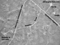 Quehanna Reactor and Jet Bunkers 1958 labels.png 1,688 × 1,271; 1.77 MB
-
 Quehanna Reactor and Jet Bunkers 1958.jpg 1,883 × 1,874; 1.43 MB
-
 Quehanna Sign 1.jpg 2,048 × 1,536; 1.16 MB
-
 Quehanna Sign 2.jpg 2,048 × 1,536; 1.18 MB
-
 Quehanna Sign 3.jpg 2,048 × 1,536; 1.01 MB
-
 Quehanna Sign 4.jpg 2,048 × 1,536; 1.18 MB
-
 Quehanna Sign 5.jpg 1,536 × 2,048; 1.08 MB
-
 Quehanna Stumps 1.jpg 2,048 × 1,536; 1.65 MB
-
 Quehanna Stumps 2.jpg 2,048 × 1,536; 1.59 MB
-
 Quehanna Trail 1.jpg 500 × 375; 113 KB
-
 Quehanna Trail 2.jpg 500 × 375; 123 KB
-
 Quehanna Wetlands.jpg 2,048 × 1,536; 949 KB
-
 Quehanna Wild Area base map.png 1,065 × 879; 73 KB
-
 Quehanna Wild Area Diffused.jpg 3,240 × 4,320; 11.68 MB
-
 Quehanna Wild Area Dissected 1.jpg 4,320 × 3,240; 10.17 MB
-
 Quehanna Wild Area Dissected 2.jpg 4,320 × 3,240; 11.45 MB
-
 Quehanna Wild Area Duality.jpg 3,605 × 4,149; 12.12 MB
-
 Quehanna Wild Area map.png 1,065 × 879; 106 KB
-
 Quehanna Wild Area Roadside.jpg 2,766 × 1,898; 5.36 MB
-
 Quehanna Wild Area Still.jpg 4,320 × 3,240; 7.92 MB
-
 Quehanna Wild Area Tentacles.jpg 3,240 × 4,320; 13.01 MB
-
 Quehanna Wild Area Warmth.jpg 2,304 × 3,072; 6.68 MB
-
 Quehanna Wykoff Run.jpg 1,536 × 2,048; 1.27 MB
-
 Reactor Road Gate.jpg 2,048 × 1,536; 1.04 MB
-
 Spires (8064457300).jpg 3,456 × 4,377; 8.81 MB
-
 Teaberry Trail (Revisited) (1) (10148636336).jpg 5,184 × 3,456; 13.85 MB
-
 Teaberry Trail (Revisited) (2) (10148583215).jpg 5,184 × 3,456; 14.41 MB
-
 Teaberry Trail (Revisited) (3) (10148611946).jpg 5,184 × 3,456; 15.33 MB
-
 Teaberry Trail (Revisited) (4) (10131301295).jpg 5,184 × 3,456; 18.41 MB
-
 Wykoff Run Natural Area Explanatory.jpg 2,304 × 3,072; 7.24 MB
-
 Wykoff Run Swift.jpg 3,274 × 3,013; 9.49 MB

_(30216442196).jpg)
_(30165646601).jpg)
_(30216216626).jpg)
_(29995807940).jpg)
_(30257423486).jpg)
_(30136087622).jpg)
_(29620656904).jpg)
_(30165845841).jpg)
_(30165915601).jpg)
_(30136158842).jpg)
_(18293135055).jpg)
_(18105367340).jpg)
.jpg)
_(11275631103).jpg)
_(11275483065).jpg)

.jpg)
.jpg)
.jpg)
.jpg)
.jpg)
.jpg)
.jpg)


.jpg)
.jpg)
_(1).jpg)
_(2).jpg)


.jpg)
_(30176641992).jpg)
_(29661788474).jpg)


.jpg)
_(1)_(10148636336).jpg)
_(2)_(10148583215).jpg)
_(3)_(10148611946).jpg)
_(4)_(10131301295).jpg)

