File:Post- und Eisenbahn-Reisekarte-Deutschland, Holland, die Schweiz, Italien bis Neapel, der grösste Theil von Frankreich, Ungarn, Polen etc. - mit besonderer Rücksicht auf Eisenbahnen u. LOC 2018588027.tif
Jump to navigation
Jump to search

Size of this JPG preview of this TIF file: 513 × 600 pixels. Other resolutions: 205 × 240 pixels | 410 × 480 pixels | 657 × 768 pixels | 876 × 1,024 pixels | 1,751 × 2,048 pixels | 7,686 × 8,988 pixels.
Original file (7,686 × 8,988 pixels, file size: 197.64 MB, MIME type: image/tiff)
Captions
Captions
Add a one-line explanation of what this file represents
Summary[edit]
| Description |
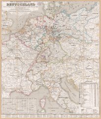
English: Post-road/railroad map of Central Europe (Germany, Benelux, Switzerland, Austria, Poland, Hungary, and adjacent regions). The component German states/principalities and adjacent countries are shown in distinctive border coloration. Title from map-content area (recto). When affixed to the cloth backing the map sheet was sectioned to 24 panels. Handwritten (cursive script) inked identification statement on paper label affixed to cloth backing (verso): German post and rail in 1856, Millard Fillmore, May 16, 1856. LC sheet imperfect: Use-worn, LC accession rubber-stamp in map-content area (top recto), lead-pencil annotations on cloth backing (verso). Includes notes, indexed table titled "Statistische Uebersicht der 38 deutschen Bundesstaaten", railroad distance table, waterways distance table, and key to abbreviations. Five paper panels with statistical tables, panel with spa/health-resort locations, panel with 6 trans-Alpine road profiles, and cover panel affixed to cloth backing (verso). Available also through the Library of Congress Web site as a raster image. Vault |
||
| Title | Post- und Eisenbahn-Reisekarte--Deutschland, Holland, die Schweiz, Italien bis Neapel, der grösste Theil von Frankreich, Ungarn, Polen etc. : mit besonderer Rücksicht auf Eisenbahnen u. Seedampfschiffahrt | ||
| Shelf ID | G6031.P2 1856 .H3 | ||
| Date | |||
| Source | https://www.loc.gov/item/2018588027/ | ||
| Author | Hanser, G.; Fillmore, Millard; Serz & Cie | ||
| Permission (Reusing this file) |
|
||
| Other versions |
|
||
| Location | Benelux Countries · Switzerland · Europe, Central · Germany · Central Europe | ||
| Part of | American Memory · Transportation And Communication · Geography And Map Division | ||
| Subject | Post Roads · Benelux Countries · Europe, Central · Railroads · German States · Maps · Germany · Road Maps · Administrative And Political Divisions · Switzerland · 19Th Century · History |


Licensing[edit]
|
This is a faithful photographic reproduction of a two-dimensional, public domain work of art. The work of art itself is in the public domain for the following reason:
The official position taken by the Wikimedia Foundation is that "faithful reproductions of two-dimensional public domain works of art are public domain".
This photographic reproduction is therefore also considered to be in the public domain in the United States. In other jurisdictions, re-use of this content may be restricted; see Reuse of PD-Art photographs for details. | ||||
File history
Click on a date/time to view the file as it appeared at that time.
| Date/Time | Thumbnail | Dimensions | User | Comment | |
|---|---|---|---|---|---|
| current | 16:41, 3 August 2018 |  | 7,686 × 8,988 (197.64 MB) | Fæ (talk | contribs) | LOC Maps https://www.loc.gov/item/2018588027/ #21137 |
You cannot overwrite this file.
File usage on Commons
The following page uses this file: