File:Portolan Atlas of the Mediterranean Sea, Western Europe, and the Northwest Coast of Africa WDL3200.pdf
Jump to navigation
Jump to search

Size of this JPG preview of this PDF file: 420 × 600 pixels. Other resolutions: 168 × 240 pixels | 336 × 480 pixels | 900 × 1,285 pixels.

Original file (900 × 1,285 pixels, file size: 254 KB, MIME type: application/pdf, 5 pages)
Captions
Captions
Add a one-line explanation of what this file represents
Summary[edit]
| Author |
Русский: Олива, Хуан (Период творчества 1580-1615 гг.)
Français : Oliva, Juan (Prospère en 1580-1615)
English: Oliva, Juan (Flourished 1580-1615)
中文:奥利瓦, 胡安 (旺盛创作期 1580-1615年)
Português: Oliva, Juan (Prosperou durante 1580-1615)
العربية: أوليفا, جوان (ازدهر في الفترة بين 1580 إلى 1615)
Español: Oliva, Juan (Prosperó entre 1580-1615) |
| Title |
Русский: Атлас-портулан Средиземного моря, Западной Европы и северо-западного побережья Африки
Français : Atlas portulans de la Mer Méditerranée, de l'Europe occidentale et des côtes de l'Afrique du Nord-Ouest.
English: Portolan Atlas of the Mediterranean Sea, Western Europe, and the Northwest Coast of Africa
中文:地中海、西欧和非洲西北海岸波多兰地图集
Português: Atlas Portulano do Mar Mediterrâneo, Europa Ocidental e Costa Noroeste da África.
العربية: أطلس بورتولان للبحر الأبيض المتوسط، وأوروبا الغربية، والساحل الشمالي الغربي لإفريقيا
Español: Atlas portuláneo del mar Mediterráneo, Europa Occidental y la costa noroeste de África |
| Description |
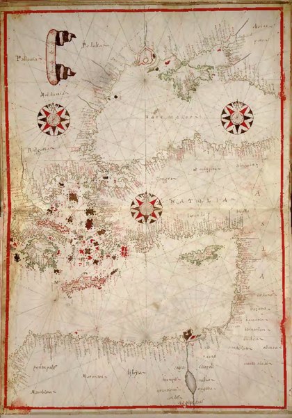
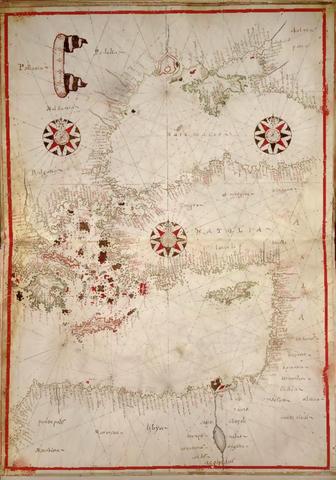
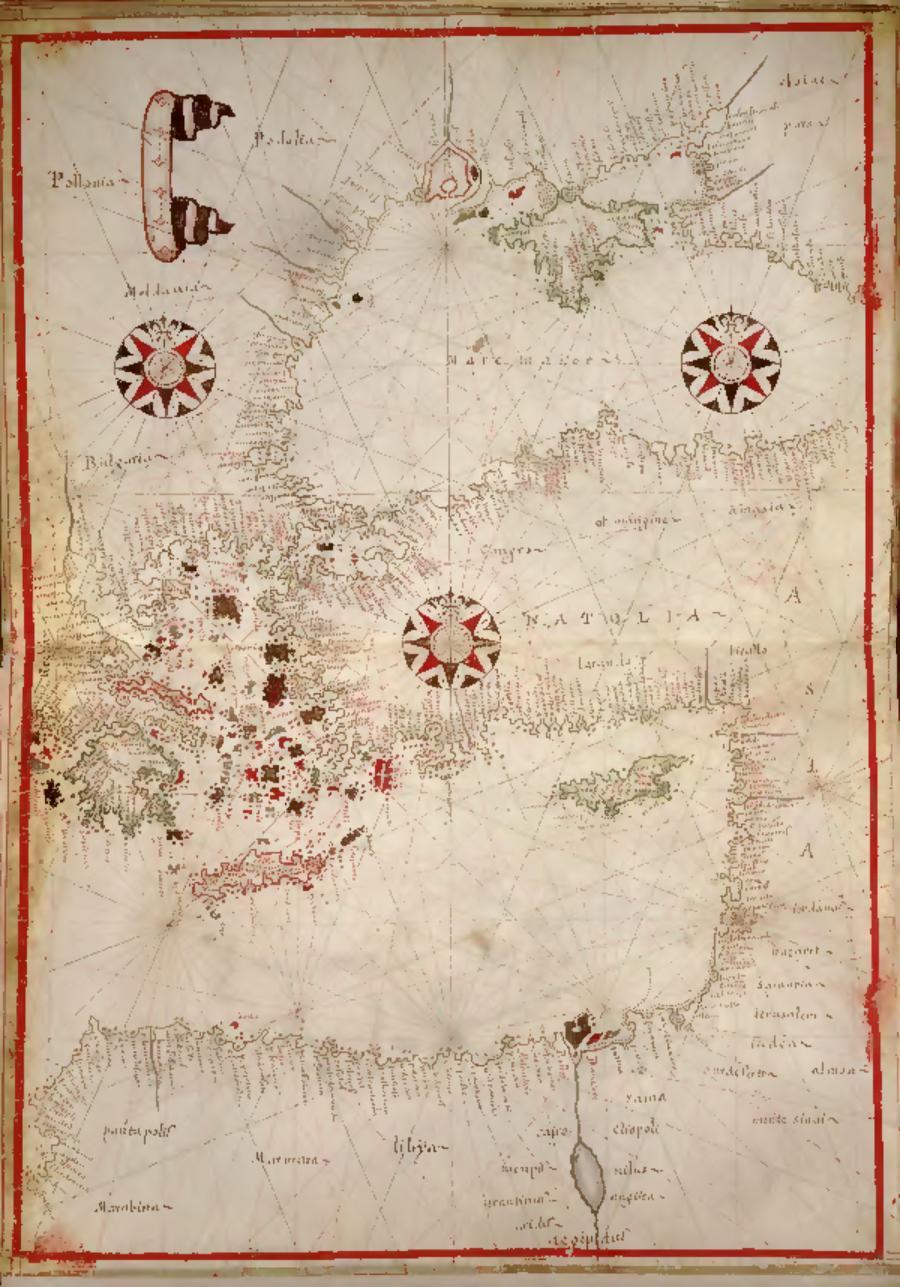
Русский: Карты-портуланы стали применять на парусных судах в Средиземноморском регионе в конце 13-го века. Отличительным признаком этих морских карт, составленных для мореплавателей, а во многих случаях самими мореплавателями, являлись система пересекающихся локсодром, перекрещивающих каждую карту, и часто присутствующее орнаментированное изображение компасной розы. Составление этого атласа, состоящего из пяти рукописных карт, приписывается Хуану Оливе, представителю прославленной династии картографов Олива из Каталонии, начавшей работать на Майорке незадолго до 1550 года. Атлас был составлен не ранее 1590 года, а возможно, уже в начале 17-го века. В состав атласа входят следующие карты: 1. восточное Средиземноморье, включая Грецию, Эгейские острова, Крит, Кипр и Черное море; 2. центральное Средиземноморье, включая Италию, Сицилию, Сардинию, Корсику и Мальту; 3. Западная Европа и Британские острова, с изображением всего побережья Испании, Португалии, Франции, Голландии, Бельгии, Люксембурга, Дании, юго-западного побережья Скандинавии, а также Британских островов; 4. северо-западная Африка, включая острова Мадейра, Канарские острова, острова Зеленого Мыса и часть Азорских островов; 5. карта мира в овальной проекции. На карте мира Северная Америка, обозначенная как "terra florida" и "nova francia", смыкается с Восточной Азией. На некоторых картах имеются рисунки кораблей.
Средиземноморский регион; Морские карты; Карты-портуланы Français : Les cartes-portulans ont commencé à être utilisées sur les voiliers en mer Méditerranée vers la fin du XIIIe siècle. Dressées pour, et souvent par les marins, ces cartes marines se caractérisaient par leur système de loxodromies, ou lignes de rhumb, qui s'entrecroisent sur chaque carte et par la rose des vents décorée qui apparaît habituellement. Cet atlas de cinq cartes manuscrites est attribué à Juan Oliva, un membre de l'illustre famille de cartographes catalans Oliva, ayant commencé à travailler à Majorque un peu avant 1550. L'atlas a été compilé au plus tôt après 1590, peut-être même au cours des premières années du XVIIe siècle. Les cartes de l'atlas sont : 1. La Méditerranée orientale, notamment la Grèce, les îles de la mer Égée, la Crète, Chypre et la mer Noire ; 2. La Méditerranée centrale, notamment l'Italie, la Sicile, la Sardaigne, la Corse et Malte ; 3. L'Europe occidentale et les îles Britanniques, avec une représentation complète des côtes d'Espagne, du Portugal, de France, des Pays-Bas belgiques, du Danemark, des côtes sud-ouest de Scandinavie et des îles Britanniques ; 4. L'Afrique du Nord, avec Madère, les îles Canaries, les îles du Cap-Vert et une partie des Açores ; et 5. Une carte du monde dressée sur une projection ovale. Sur la carte du monde, l'Amérique du Nord est identifiée par « terra florida » et « nova francia » et se rattache à l'Asie de l'Est. Plusieurs cartes comportent des dessins de navires.
Région méditerranéenne; Cartes marines; Cartes-portulans English: Portolan charts came into use on sailing vessels in the Mediterranean Sea toward the end of the 13th century. Made for and, in many cases, by seamen, these nautical maps were characterized by the system of intersecting loxodromes, or rhumb lines, which crisscross each chart and the ornamented compass rose that usually appears. This atlas of five manuscript charts has been attributed to Juan Oliva, a member of the illustrious Oliva family of Catalan chartmakers who began working in Majorca some time before 1550. The atlas was compiled no earlier than 1590 and perhaps as late as the first few years of the 17th century. The maps in the atlas are: 1. the eastern Mediterranean, including Greece, the Aegean islands, Crete, Cyprus, and the Black Sea; 2. the central Mediterranean, including Italy, Sicily, Sardinia, Corsica, and Malta; 3. Western Europe and the British Isles, showing the entire coasts of Spain, Portugal, France, the Low Countries, Denmark, the southwest coast of Scandinavia, and the British Isles; 4. northwest Africa, including Madeira, the Canary Islands, the Cape Verde Islands, and part of the Azores; and 5. a world map drawn on an oval projection. In the world map, North America, identified as “terra florida” and “nova francia,” is joined with eastern Asia. Several of the maps include drawings of ships.
Mediterranean Region; Nautical charts; Portolan charts 中文:波多兰航海图在 13 世纪末开始用于航行于地中海地区的海船。这些航海图是海员绘制,多数情形下也是海员在使用,以交叉的等方位线,或者叫等角航线为特征,十字记号和装饰化的罗盘经常出现在每张图上。这卷地图集有五张手绘地图,为胡安•奥利瓦所制,他是著名的加泰罗尼亚地图制造者奥利瓦家族的成员,该家族从早于 1550 年的某个时候就开始在马略卡岛工作。地图集应编辑于不早于 1590 年,可能最晚是 17 世纪的最初的几年。地图集里的地图有:1. 东地中海,包括希腊、爱琴海诸岛、克里特岛、塞浦路斯和黑海;2. 中地中海,包括意大利、西西里岛、撒丁岛、科西嘉岛和马耳他;3. 西欧和不列颠群岛,显示了整个西班牙海岸、葡萄牙、法国、低地国家、丹麦、斯堪的纳维亚的西南海岸以及不列颠群岛;4. 西北非,包括马德拉岛、加那利群岛,佛得角群岛和亚速尔群岛的部分;5. 椭圆形投影的世界地图。在世界地图里,被标识为“佛罗里达之地”和“新法兰西”的北美洲同东亚连接在一起。有几张地图上绘有船舶。
地中海区域; 航海图; 波多兰航海图 Português: As cartas portulanas começaram a ser usadas em embarcações a vela no Mar Mediterrâneo no final do século 13. Feitos para e, em muitos casos, pelos marinherios, estes mapas náuticos foram caracterizados pelo sistema de interseção loxodrômica ou de linhas de rumo, que entrecruzam cada carta e também pela rosa dos ventos ornamentada que normalmente está presente. Este atlas de cinco cartas manuscritas foi atribuído a Juan Oliva, um membro da ilustre família Oliva de cartógrafos catalões que começou a trabalhar em Maiorca antes de 1550. O atlas não foi compilado antes de 1590 ou talvez até bem mais tarde, nos primeiros anos do século 17. Os mapas no atlas são: 1. 1. Mediterrâneo Oriental, incluindo Grécia, ilhas Egeu, Creta, Chipre e o Mar Negro; 2. Mediterrâneo Central, incluindo Itália, Sicília, Sardenha, Córsega e Malta; 3. Europa Ocidental e as Ilhas Britânicas, mostrando toda a costa da Espanha, Portugal, França, Países Baixos, Dinamarca, costa sudoeste da Escandinávia e as Ilhas Britânicas; 4. nordeste da África, incluindo Madeira, Ilhas Canárias, Ilhas de Cabo Verde, e parte dos Açores; e 5. um mapa-múndi desenhado em projeção oval. No mapa-múndi, América do Norte, indentificada como "terra florida" (terra florida) e "nova francia" (nova frança), está ligada à Ásia Oriental. Muitos dos mapas incluem desenhos de navios.
Região Mediterrânea; Cartas náuticas; Cartas portulanas العربية: دخلت رسوم بورتولان حيز الاستخدام على متن السفن الشراعية في البحر الأبيض المتوسط في أواخر القرن الثالث عشر. وحيث إنها وُضعت من أجل البحارة وبمعرفتهم، فإن هذه الخرائط البحرية اتسمت بنظام "لوكسودروم"، أو خطوط البوصلة، والتي تتقاطع في كل خريطة والتي غالبًا ما يظهر فيها محور البوصلة المزخرف. وهذا الأطلس الذي يضم خمس مخطوطات خرائط يعود إلى جوان أوليفا، الذي كان عضوًا في أسرة أوليفا الكاتالانية الشهيرة التي كان أفرادها من واضعي الخرائط، والذي بدأ العمل في مايوركا قبل عام 1550. ولم يتم تجميع الأطلس قبل عام 1590، وربما لم يتم ذلك حتى بعد مرور السنوات القليلة الأولى من القرن السابع عشر. والخرائط التي يتضمنها الأطلس هي: 1. شرقي البحر الأبيض المتوسط، بما في ذلك اليونان وجزر بحر إيجه وكريت وقبرص والبحر الأسود؛ 2. وسط البحر الأبيض المتوسط، بما في ذلك إيطاليا وصقلية وسردينيا وكورسيكا ومالطة؛ 3. أوروبا الغربية والجزر البريطانية، وتوضح كامل سواحل إسبانيا والبرتغال وفرنسا والدول المنخفضة والدنمارك والساحل الجنوبي الغربي للدول الاسكندنافية، والجزر البريطانية؛ 4. شمالي غرب إفريقيا، بما في ذلك الماديرا وجزر الكناري وجزر الرأس الأخضر وجزء من جزر الآزور؛ و5. خريطة العالم مرسومة على مسقط بيضاوي. وفي خريطة العالم، تم ضم أمريكا الشمالية، التي كان اسمها "تيرا فلوريدا" (أرض فلوريدا) و"نوفا فرانشيا" (فرنسا الجديدة)، مع شرق آسيا. ويحتوي العديد من الخرائط على رسومات للسفن.
منطقة البحر الأبيض المتوسط; الخرائط البحرية; الرسوم البيانية البورتولانية Español: Las cartas portuláneas comenzaron a utilizarse en barcos de vela en el mar Mediterráneo hacia finales del siglo XIII. Hechas para, y en muchos casos por, marinos; estas cartas náuticas se caracterizaban por un sistema de líneas loxodrómicas o líneas de rumbo que se intersectaban en todas las cartas y por la rosa de los vientos decorada que aparecía normalmente. Se ha atribuido el atlas de cinco cartas manuscritas a Juan Oliva: un miembro de la ilustre familia Oliva de cartógrafos catalanes, que comenzó a trabajar en Mallorca un poco antes de 1550. El atlas no fue compilado antes de 1590, o incluso en los primeros años del siglo XVII. Los mapas en el atlas son: 1. el Mediterráneo oriental, que incluye Grecia, las islas del Egeo, Creta, Chipre y el mar Negro; 2. el Mediterráneo central, que incluye Italia, Sicilia, Cerdeña, Córcega y Malta; 3. Europa occidental y las Islas Británicas, donde se muestran las costas de toda España, Portugal, Francia, los Países Bajos, Dinamarca, la costa suroeste de Escandinavia y las Islas Británicas; 4. el noroeste de África, incluyendo Madeira, las Islas Canarias, las islas de Cabo Verde, y parte de Azores; y 5. un mapamundi dibujado en una proyección oval. En el mapamundi, Norteamérica, identificada como «terra florida» y «nova francia», está unida a Asia oriental. Varios de los mapas incluyen dibujos de barcos.
Región del Mediterráneo; Cartas náuticas; Cartas portulanas |
| Date | between 1590 and 1615 |
| Medium |
Русский: Карты
Français : Cartes
English: Maps
中文:地图
Português: Mapas
العربية: خرائط
Español: Mapas |
| Dimensions |
English: 1 manuscript atlas ([22] pages) : color illustrations, color maps, vellum ; 29 centimeters |
| Collection |
Русский: Библиотека Конгресса
Français : Bibliothèque du Congrès
English: Library of Congress
中文:国会图书馆
Português: Biblioteca do Congresso
العربية: مكتبة الكونغرس
Español: Biblioteca del Congreso |
| Place of creation |
Русский: Европа
Français : Europe
English: Europe
中文:欧洲
Português: Europa
العربية: أوروبا
Español: Europa |
| Notes |
Русский: Название дано составителем каталога.
Français : Titre fourni par le catalographe.
English: Title supplied by cataloger.
中文:编目者提供的标题。
Português: Título fornecido pelo catalogador.
العربية: تم توفير العنوان من قبل المفهرس.
Español: Título suministrado por catalogador. |
| References | http://hdl.loc.gov/loc.wdl/dlc.3200 |
| Source/Photographer |
http://dl.wdl.org/3200/service/3200.pdf
|
Licensing[edit]
|
This is a faithful photographic reproduction of a two-dimensional, public domain work of art. The work of art itself is in the public domain for the following reason:
The official position taken by the Wikimedia Foundation is that "faithful reproductions of two-dimensional public domain works of art are public domain".
This photographic reproduction is therefore also considered to be in the public domain in the United States. In other jurisdictions, re-use of this content may be restricted; see Reuse of PD-Art photographs for details. | ||||
File history
Click on a date/time to view the file as it appeared at that time.
| Date/Time | Thumbnail | Dimensions | User | Comment | |
|---|---|---|---|---|---|
| current | 14:37, 11 March 2014 |  | 900 × 1,285, 5 pages (254 KB) | Fæ (talk | contribs) | =={{int:filedesc}}== {{Artwork |artist = |author ={{ru|1=Олива, Хуан (Период творчества 1580-1615 гг.)}} {{fr|1=Oliva, Juan (Prospère en 1580-1615)}} {{en|1=Oliva, Juan (Flourished 1580-1615)}} {{zh|1=奥利瓦, 胡安 (�... |
You cannot overwrite this file.
File usage on Commons
The following 2 pages use this file:
- File:Portolan Atlas of the Mediterranean Sea, Western Europe, and the Northwest Coast of Africa WDL3200.pdf
- File:Portolan atlas of the Mediterranean Sea, western Europe, and the northwest coast of Africa World map drawn on an oval projection (ca. 1590) by Joan Oliva. Original from Library of Congress. Digitally enhanced by rawpixel. (50623611251).jpg
_by_Joan_Oliva._Original_from_Library_of_Congress._Digitally_enhanced_by_rawpixel._(50623611251).jpg)