File:Population by Pakistani District - 2017 Census.svg
Jump to navigation
Jump to search

Size of this PNG preview of this SVG file: 800 × 500 pixels. Other resolutions: 320 × 200 pixels | 640 × 400 pixels | 1,024 × 640 pixels | 1,280 × 800 pixels | 2,560 × 1,600 pixels | 3,200 × 2,000 pixels.
Original file (SVG file, nominally 3,200 × 2,000 pixels, file size: 2.43 MB)
Captions
Captions
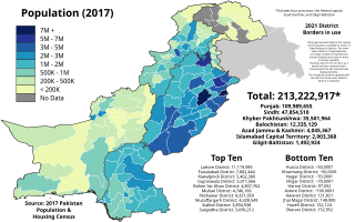
Population of each Pakistani District as of the 2017 Pakistan Census
Summary[edit]
| Description |
English: The map above shows the resident population of each Pakistani district according to the final official results of the 2017 Pakistan Population & Housing Census. The data can be found here for the four provinces and ICT, here for Azad Kashmir, and here for Gilgit-Baltistan.
NOTE: Only approximate data (to the nearest ten thousand) is available for seven of Gilgit-Baltistan's districts. The other seven districts of Gilgit-Baltistan are newly created (or experienced border changes) and data for them is not yet available. However, data for the territory as a whole has been released and is incorporated into the national total displayed below. This image file shall be updated with the data for those seven districts when it is released. Legend 7M+
5M - 7M
3M - 5M
2M - 3M
1M - 2M
500K - 1M
200K - 500K
< 200K |
| Date | |
| Source |
This file was derived from: Blank Districts of Pakistan.svg: |
| Author | Abbasi786786 |
Licensing[edit]
I, the copyright holder of this work, hereby publish it under the following license:
This file is licensed under the Creative Commons Attribution-Share Alike 4.0 International license.
- You are free:
- to share – to copy, distribute and transmit the work
- to remix – to adapt the work
- Under the following conditions:
- attribution – You must give appropriate credit, provide a link to the license, and indicate if changes were made. You may do so in any reasonable manner, but not in any way that suggests the licensor endorses you or your use.
- share alike – If you remix, transform, or build upon the material, you must distribute your contributions under the same or compatible license as the original.
File history
Click on a date/time to view the file as it appeared at that time.
| Date/Time | Thumbnail | Dimensions | User | Comment | |
|---|---|---|---|---|---|
| current | 23:56, 20 November 2021 | | 3,200 × 2,000 (2.43 MB) | Abbasi786786 (talk | contribs) | Fix Lakki Marwat |
| 20:27, 4 August 2021 |  | 3,200 × 2,000 (2.43 MB) | Abbasi786786 (talk | contribs) | slight movement | |
| 20:22, 4 August 2021 |  | 3,200 × 2,000 (2.43 MB) | Abbasi786786 (talk | contribs) | Improved dagger note | |
| 20:11, 4 August 2021 |  | 3,200 × 2,000 (2.43 MB) | Abbasi786786 (talk | contribs) | Added Gilgit-Baltistan data, improved template | |
| 20:20, 5 June 2021 |  | 3,200 × 2,000 (1.54 MB) | Abbasi786786 (talk | contribs) | Uploaded own work with UploadWizard |
You cannot overwrite this file.
File usage on Commons
The following page uses this file:
- File:Population by Pakistani District.svg (file redirect)
File usage on other wikis
The following other wikis use this file:
- Usage on en.wikipedia.org
- Usage on ko.wikipedia.org