File:Plan of Amelia Island in East Florida, north point of Amelia Island lyes in 30-55 north latitude 80-23 w. longitude from London, taken from De Brahm's Map of South Caroline & Georgia. A chart of the LOC 73694443.tif
Jump to navigation
Jump to search

Size of this JPG preview of this TIF file: 709 × 599 pixels. Other resolutions: 284 × 240 pixels | 568 × 480 pixels | 908 × 768 pixels | 1,211 × 1,024 pixels | 2,422 × 2,048 pixels | 7,940 × 6,713 pixels.
Original file (7,940 × 6,713 pixels, file size: 152.5 MB, MIME type: image/tiff)
Captions
Captions
Add a one-line explanation of what this file represents
Summary[edit]
| Description |
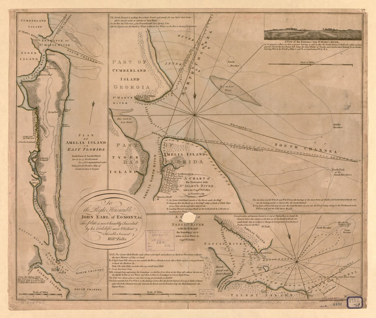
English: Scales vary. Relief shown pictorially and by hachures. Depths shown by soundings. Hand colored. From W. Faden's The North American atlas. 1777. Includes notes and "A view of the entrance into St. Mary's River." LC Maps of North America, 1750-1789, 1630 Available also through the Library of Congress Web site as a raster image. LC copy imperfect: Hole in lower center. Vault AACR2: 100; 651/1; 650/2; 650/3; 700/3 |
||
| Title | Plan of Amelia Island in East Florida, north point of Amelia Island lyes in 30:55 north latitude 80:23 w. longitude from London, taken from De Brahm's Map of South Caroline & Georgia. A chart of the entrance into St. Mary's River, | ||
| Shelf ID | G3932.A4 1770 .J4 | ||
| Date | |||
| Source | https://www.loc.gov/item/73694443/ | ||
| Author | Jefferys, Thomas; De Brahm, John Gerar William; Fuller, William; Faden, William | ||
| Permission (Reusing this file) |
|
||
| Other versions |
|
||
| Location | United States · Florida · Amelia Island | ||
| Part of | Military Battles And Campaigns · American Memory · Catalog · Geography And Map Division · American Revolution And Its Era: Maps And Charts Of North America And The West Indies, 1750-1789 | ||
| Subject | Florida · Nautical Charts · Amelia Island · United States · Maps · Early Works To 1800 · Amelia Island (Fla.) · Harbors |


Licensing[edit]
|
This is a faithful photographic reproduction of a two-dimensional, public domain work of art. The work of art itself is in the public domain for the following reason:
The official position taken by the Wikimedia Foundation is that "faithful reproductions of two-dimensional public domain works of art are public domain".
This photographic reproduction is therefore also considered to be in the public domain in the United States. In other jurisdictions, re-use of this content may be restricted; see Reuse of PD-Art photographs for details. | ||||
File history
Click on a date/time to view the file as it appeared at that time.
| Date/Time | Thumbnail | Dimensions | User | Comment | |
|---|---|---|---|---|---|
| current | 13:42, 13 June 2018 |  | 7,940 × 6,713 (152.5 MB) | Fæ (talk | contribs) | LOC Maps https://www.loc.gov/item/73694443/ #14205 |
You cannot overwrite this file.
File usage on Commons
The following page uses this file: