File:Paris city Landsat 2.png
Jump to navigation
Jump to search

Size of this preview: 800 × 534 pixels. Other resolutions: 320 × 213 pixels | 640 × 427 pixels | 901 × 601 pixels.
Original file (901 × 601 pixels, file size: 1.02 MB, MIME type: image/png)
Captions
Captions
Add a one-line explanation of what this file represents
Summary[edit]
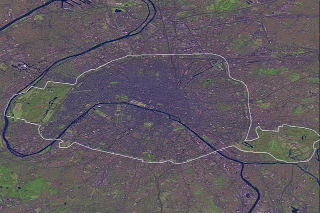
| Description |
Deutsch: Paris mit Stadtgrenze auf einer Landsat-Falschfarben-Aufnahme
English: Paris with city limits by Landsat (false colours) |
| Date | |
| Source | file:Paris city Landsat.png |
| Author | United States National Geospatial-Intelligence Agency, edited by NordNordWest |
This image was generated by the NGA Raster Roam application, at coordinates 48°51'39"N 2°20'43"E.
This image is a work of the United States National Geospatial-Intelligence Agency or one of its predecessor agencies. As a work of the U.S. federal government, the image is in the public domain.
|
 |
File history
Click on a date/time to view the file as it appeared at that time.
| Date/Time | Thumbnail | Dimensions | User | Comment | |
|---|---|---|---|---|---|
| current | 16:26, 7 April 2013 | | 901 × 601 (1.02 MB) | NordNordWest (talk | contribs) | == {{int:filedesc}} == {{Information |Description= {{de|Paris mit Stadtgrenze auf einer Landsat-Falschfarben-Aufnahme}} {{en|Paris with city limits by Landsat (false colours)}} |Source=file:Paris city Landsat.png |Date=... |
You cannot overwrite this file.
File usage on Commons
There are no pages that use this file.
File usage on other wikis
The following other wikis use this file:
- Usage on de.wikipedia.org
- Usage on nl.wikipedia.org