File:Overhill-cherokee-little-tennessee.jpg
Jump to navigation
Jump to search
No higher resolution available.
Overhill-cherokee-little-tennessee.jpg (510 × 220 pixels, file size: 41 KB, MIME type: image/jpeg)
Captions
Captions
Add a one-line explanation of what this file represents
Summary[edit]
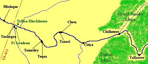
| Description | Overhill Cherokee villages along the Little Tennessee River, c. 1700-1800. Red lines and letters indicate modern structures. Fort Loudoun was built by Virginia and South Carolina in 1756, and destroyed by the Cherokee in 1760. The Tellico Blockhouse was built in 1794 by the U.S. government and abandoned in 1807. The town of Vonore, Tennessee is situated around where US-411 crosses the river. Tallassee was located about a mile downstream from the modern Calderwood Dam. Map NOT drawn to scale. |
| Date | |
| Source | Own work |
| Author | Brian Stansberry |
Licensing[edit]
I, the copyright holder of this work, hereby publish it under the following licenses:

|
Permission is granted to copy, distribute and/or modify this document under the terms of the GNU Free Documentation License, Version 1.2 or any later version published by the Free Software Foundation; with no Invariant Sections, no Front-Cover Texts, and no Back-Cover Texts. A copy of the license is included in the section entitled GNU Free Documentation License. |
This file is licensed under the Creative Commons Attribution 3.0 Unported license.
- You are free:
- to share – to copy, distribute and transmit the work
- to remix – to adapt the work
- Under the following conditions:
- attribution – You must give appropriate credit, provide a link to the license, and indicate if changes were made. You may do so in any reasonable manner, but not in any way that suggests the licensor endorses you or your use.
You may select the license of your choice.
| Annotations | This image is annotated: View the annotations at Commons |
File history
Click on a date/time to view the file as it appeared at that time.
| Date/Time | Thumbnail | Dimensions | User | Comment | |
|---|---|---|---|---|---|
| current | 14:56, 26 October 2007 | | 510 × 220 (41 KB) | BrineStans (talk | contribs) | {{Information |Description=Overhill Cherokee villages along the Little Tennessee River, c. 1700-1800. Red lines and letters indicate modern structures. Fort Loudoun was built by Virginia and South Carolina in 1756, and destroyed by the Cherokee in 1760. |
You cannot overwrite this file.
File usage on Commons
There are no pages that use this file.
File usage on other wikis
The following other wikis use this file:
- Usage on en.wikipedia.org
Metadata
Categories:
- Maps of the history of Tennessee
- Overhill Cherokee
- Cherokee maps
- 18th-century Native American history
- 18th-century maps of Tennessee
- Pre-statehood history of Tennessee
- Little Tennessee River
- Native American villages and towns
- Tellico Blockhouse
- Chota (Cherokee town)
- Fort Loudoun (Tennessee)
- Tallassee, Alabama
- Chilhowee (Cherokee town)
- Tanasi
- Tuskegee (Cherokee town)
- Toqua (Cherokee town)
- Citico (Cherokee town)