File:Old cadastral map of Praha-Josefov and surround areas.jpg
Jump to navigation
Jump to search

Size of this preview: 670 × 599 pixels. Other resolutions: 268 × 240 pixels | 537 × 480 pixels | 859 × 768 pixels | 1,145 × 1,024 pixels | 2,290 × 2,048 pixels | 3,328 × 2,976 pixels.
Original file (3,328 × 2,976 pixels, file size: 4.73 MB, MIME type: image/jpeg)
Captions
Captions
Add a one-line explanation of what this file represents
Summary[edit]
| Description |
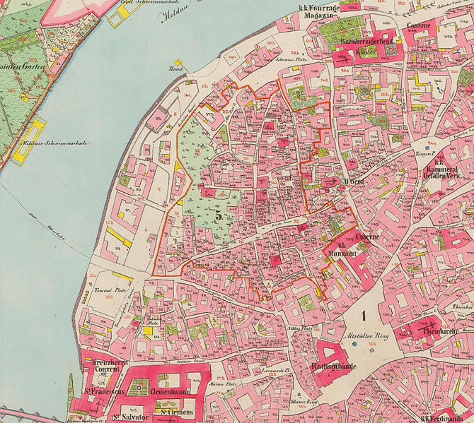
English: Old cadastral map of original Praha-Josefov cadastral area and surround areas
Čeština: Mapa stabilního katastru Prahy-Josefova s okolím, pocházející z řady povinných císařských otisků. Mapováno 1842, opravené vydání 1852. |
| Date | |
| Source | http://archivnimapy.cuzk.cz/coc/6068-1/6068-1-002_index.html |
| Author | Offices of the Austrian Empire |
|
This work is in the public domain in its country of origin and other countries and areas where the copyright term is the author's life plus 70 years or fewer. This work is in the public domain in the United States because it was published (or registered with the U.S. Copyright Office) before January 1, 1929. | |
| This file has been identified as being free of known restrictions under copyright law, including all related and neighboring rights. | |

|
This file was created on the basis of data provided by the Central Archives of Surveying and Land Register (State Administration of Land Surveying and Cadastre).
|
File history
Click on a date/time to view the file as it appeared at that time.
| Date/Time | Thumbnail | Dimensions | User | Comment | |
|---|---|---|---|---|---|
| current | 15:04, 28 January 2015 | | 3,328 × 2,976 (4.73 MB) | MagentaGreen (talk | contribs) | Wasserzeichen entfernt; Bildzuschnitt (Vielfaches von 16 px); Photoshop Speicheroptionen: Qualität 11 (97%) |
| 22:46, 27 January 2013 |  | 3,331 × 2,981 (6.87 MB) | Slick-o-bot (talk | contribs) | Bot: convert to a non-interlaced jpeg (see bug #17645) | |
| 23:07, 4 June 2008 |  | 3,331 × 2,981 (6.16 MB) | Kirk979 (talk | contribs) | {{Information |Description={{en|1=Old cadastral map of original Praha-Josefov cadastral area and surround areas}} {{cs|1=Stará katastrální mapa původního katastru Prahy-Josefova s okolím, pocházející z řady povinných císařských otisků}} |So |
You cannot overwrite this file.
File usage on Commons
The following page uses this file:
File usage on other wikis
The following other wikis use this file:
- Usage on cs.wikipedia.org
- Usage on de.wikipedia.org
- Usage on eu.wikipedia.org