File:Old Settlers Park Disc Golf Course map in 2003 - Signage error (holes 4,5,6 shown twice).jpg
Jump to navigation
Jump to search

Size of this preview: 800 × 600 pixels. Other resolutions: 320 × 240 pixels | 640 × 480 pixels | 1,024 × 768 pixels | 1,280 × 960 pixels | 1,600 × 1,200 pixels.
Original file (1,600 × 1,200 pixels, file size: 456 KB, MIME type: image/jpeg)
Captions
Captions
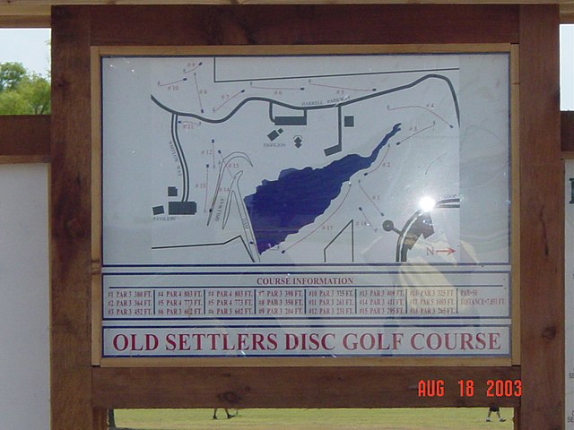
Old Settlers Park Disc Golf Course map in 2003 - Signage error (holes 4,5,6 shown twice)
Summary[edit]
.jpg&action=edit§ion=1)
| Description |
English: COURSE INFORMATION
 #1 PAR 3 380 FT.
 #2 PAR 3 364 FT.
 #3 PAR 3 452 FT.
#4 PAR 4 803 FT. #5 PAR 4 773 FT. #6 PAR 3 602 FT. #4 PAR 4 803 FT. //these display twice on the sign #5 PAR 4 773 FT. //these display twice on the sign #6 PAR 3 602 FT. //these display twice on the sign #7 PAR 3 398 FT. #8 PAR 3 350 FT. #9 PAR 3 204 FT. #10 PAR 3 325 FT. #11 PAR 3 261 FT. #12 PAR 3 231 FT. #13 PAR 3 409 FT. #14 PAR 3 411 FT. #15 PAR 3 295 FT. #16 PAR 3 325 FT. #17 PAR 5 1003 FT. #18 PAR 3 265 FT. PAR = 58 DISTANCE = 7,851 FT. OLD SETTLERS DISC GOLF COURSEAUG 18 2003 |
| Date | |
| Source | https://www.flickr.com/photos/cityofroundrock/2105940116/ |
| Author | cityofroundrock |
Licensing[edit]
.jpg&action=edit§ion=2)
This file is licensed under the Creative Commons Attribution 2.0 Generic license.
- You are free:
- to share – to copy, distribute and transmit the work
- to remix – to adapt the work
- Under the following conditions:
- attribution – You must give appropriate credit, provide a link to the license, and indicate if changes were made. You may do so in any reasonable manner, but not in any way that suggests the licensor endorses you or your use.
| This image was originally posted to Flickr by cityofroundrock at https://flickr.com/photos/7347713@N08/2105940116. It was reviewed on 4 December 2020 by FlickreviewR 2 and was confirmed to be licensed under the terms of the cc-by-2.0. |
| Annotations | This image is annotated: View the annotations at Commons |
.jpg)
File history
Click on a date/time to view the file as it appeared at that time.
| Date/Time | Thumbnail | Dimensions | User | Comment | |
|---|---|---|---|---|---|
| current | 18:30, 4 December 2020 | | 1,600 × 1,200 (456 KB) | Iketsi (talk | contribs) | Uploaded a work by cityofroundrock from https://www.flickr.com/photos/cityofroundrock/2105940116/ with UploadWizard |
You cannot overwrite this file.
File usage on Commons
The following page uses this file:
.jpg&oldid=850319739)